Downscaling with Head Loss due to Land Cover in Kalpana
Originally developed as a tool for visualizing ADCIRC output, Kalpana has evolved to include methods for downscaling ADCIRC water elevation results. The first method, now referred to as the static method, extrapolated ADCIRC water elevations horizontally until intersecting an equivalent DEM elevation. More information about the static method and about downscaling ADCIRC results with Kalpana can be found on an earlier post.
The static method has proven to be a useful tool but incorporates minimal physics. Therefore, a new method, referred to as the head loss method, has been introduced to include energy dissipation due to land cover during overland flow events. In this page, we describe the theory of the head loss method and provide examples for how to apply it using Kalpana.
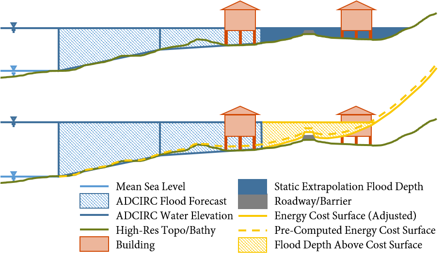
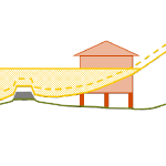
Side-view schematic of downscaling methods. A one-dimensional schematic is displayed for each of the two downscaling methods, where the top figure is the static method and the bottom is the head loss method. In the static method, the water elevations from ADCIRC (blue hatched portion) are extrapolated as a flat surface until they intersect the DEM. In the head loss method, these water elevations are extrapolated to an energy cost surface (elevation plus cumulative head loss).
Storm-Driven Erosion and Inundation of Barrier Islands from Dune- to Region-Scales
 Barrier islands are susceptible to erosion, overwash, and breaching during intense storms. However, these processes are not represented typically in large-domain models for storm surge and coastal inundation. In this study, we explore the requirements for bridging the gap between dune-scale morphodynamic and region-scale flooding models. A high-resolution XBeach model is developed to represent the morphodynamics during Hurricane Isabel (2003) in the North Carolina (NC) Outer Banks. The model domain is extended to more than 30 km of Hatteras Island and is thus larger than in previous studies. The predicted dune erosion is in good agreement with post-storm observed topography, and an ‘‘excellent’’ Skill Score of 0.59 is obtained on this large domain. Sensitivity studies show the morphodynamic model accuracy is decreased as the mesh spacing is coarsened in the cross-shore direction, but the results are less sensitive to the alongshore resolution. A new metric to assess model skill, Water Overpassing Area (WOA), is introduced to account for the available flow pathway over the dune crest. Together, these findings allow for upscaled parameterizations of erosion in larger-domain models. The updated topography, obtained from XBeach prediction, is applied in a region-scale flooding model, thus allowing for enhanced flooding predictions in communities along the Outer Banks. It is found that, even using a fixed topography in region-scale model, the flooding predictions are improved significantly when post-storm topography from XBeach is implemented. These findings can be generalized to similar barrier island systems, which are common along the U.S. Gulf and Atlantic coasts.
Binary Building Attribute Imputation, Evaluation, and Comparison Approaches for Hurricane Damage Data Sets
 Missing building attributes are problematic for development of data-based fragility models. Relative to other disciplines, the application of imputation techniques is limited in the field of engineering. Current imputation techniques to replace missing building attributes lack evaluations of imputation model performance, which ensure accuracy and validity of the imputed data. This paper presents two imputation approaches, along with imputation diagnostic and comparison approaches, for binary building attribute data with missing observations. Predictive mean matching (PMM) and multiple imputation (MI) are used to impute foundation type and number of stories attributes. The diagnostic approach, based on the logistic regression goodness-of-fit test, is used to evaluate the imputation model fit. The comparison approach, based on the percentage of correctly imputed observations, is used to evaluate the imputation model performance. A data set of single-family homes damaged by the 2005 Hurricane Katrina is used to demonstrate implementation of the methodology. Based on the comparison approach, PMM models showed 9% and 2% greater accuracy than MI models in imputing foundation type and number of stories, respectively.
Improving the Accuracy of a Real-Time ADCIRC Storm Surge Downscaling Model
 During major storm events such as hurricanes, emergency managers rely on fast and accurate forecasting models to make important decisions concerning public safety. These models can be computationally costly and cannot quickly make predictions at the highest geospatial resolution. However, model output can be post-processed to mimic high-resolution results with minimal additional computational cost. This research proposes methods for improvement in the accuracy of downscaling (enhancing the resolution of) a real-time storm surge forecasting model. Such improvements to downscaling methods include 1) expansion in its spatial applicability, 2) adding physics using water surface slopes, and 3) adding physics using friction losses across the ground surface.
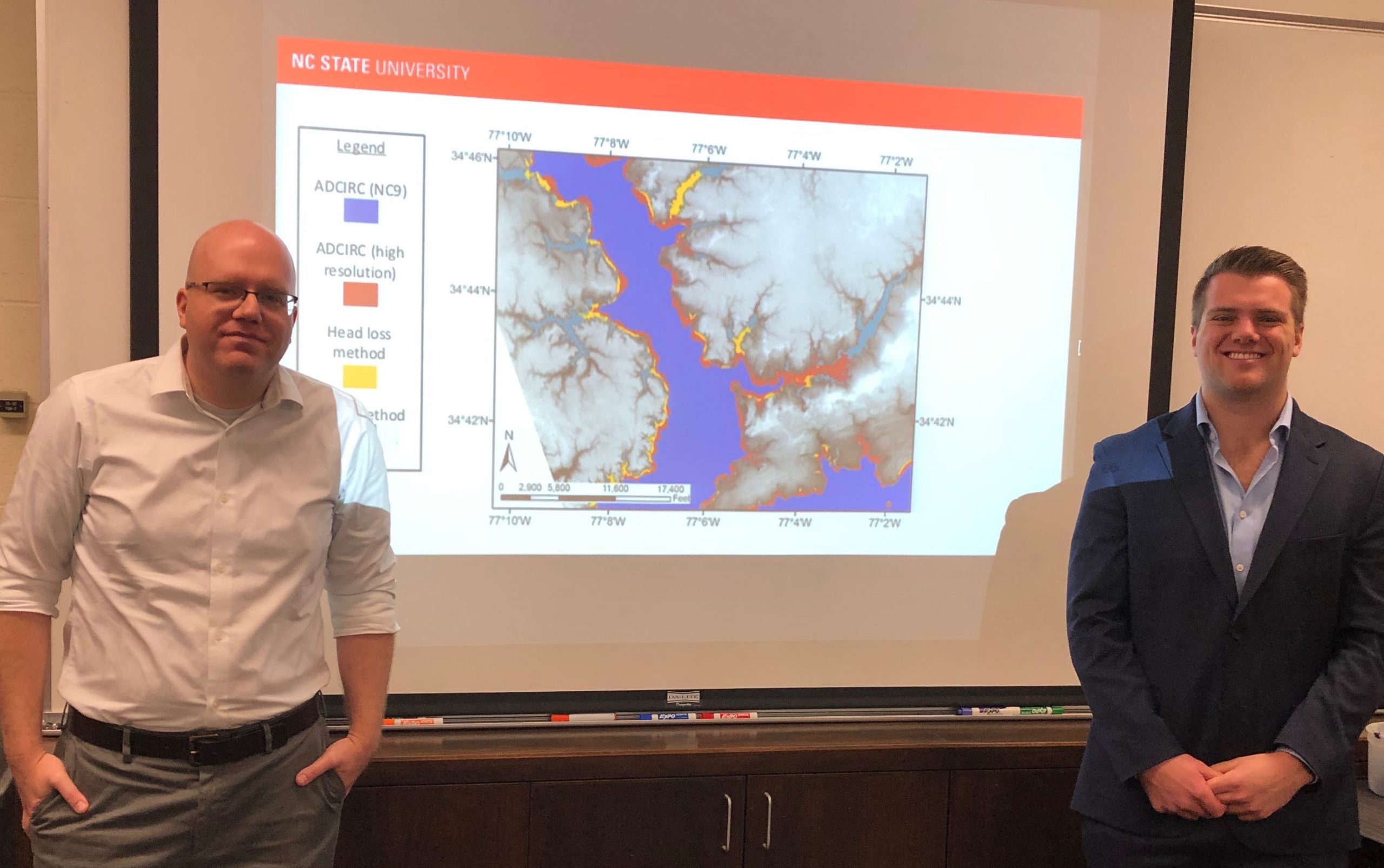
This research builds upon a process that uses maximum water elevation output from the Advanced Circulation (ADCIRC) model and downscales these results to a finer resolution by extrapolating the water levels to small-scale topography. This downscaling process is referred to as the static method. The method was originally designed for use in North Carolina (NC), where results from an ADCIRC model designed specifically for NC were downscaled to a set of NC topographical data. By joining the static method with an ADCIRC output visualization tool, the downscaling process is now able to run faster with the same level of accuracy and can run on any ADCIRC model with downscaling data from any geographical region or given resolution. This process is used to provide extra guidance to emergency managers and decision makers during hurricanes.
 The downscaling process is also improved by adding physics using the slopes method and the head loss method. The slopes method incorporates the slopes of the water levels produced by ADCIRC, rather than only the value of the water level. By interpolating ADCIRC output water elevation points into a smooth surface, slopes of this surface can be used to influence the elevations of downscaled water levels. The head loss method adds friction loss due to variations in the ground surface based on land cover types and friction associated with each type. As water travels over any surface, head loss, or a loss in energy, occurs at different rates depending on the surface roughness. This rudimentary hydrologic principle is applied to increase the accuracy of the downscaling process at minimal cost. The downscaling methods are applied for results from an ADCIRC simulation used in real-time forecasting, and then compared with results from an ADCIRC simulation with 10 times more resolution in Carteret County, NC. The static method tends to over-estimate the flood extents, and the slopes method is similar. However, the head loss method generates a downscaled flooding extent that is a close match to the predictions from the higher-resolution, full-physics model.
By improving the accuracy of downscaling methods at minimal computational cost and expanding the applicability of these downscaling methods, these methods can be used by emergency managers to provide a better estimation of flooding extents while simulating storm events.
Socially Distant Movie Party

The coastal engineering team at NC State enjoyed a Socially Distant Movie Party on Sat Apr 4. From our separate homes, we watched Sharknado and Cloudy with a Chance of Meatballs, which are mildly “coastal” and good distractions. It was fun to connect with each other, even from a distance. Stay healthy!
Virtual Conference: ADCIRC 2020
Carter Rucker defends MS Thesis
Despite a challenging situation in the world, we gathered for a successful MS thesis defense by Carter Rucker. With only a few people in the room and a larger online audience, Carter presented his research and answered questions with great skill. Congrats to Carter!