Coastal storm‑tide flooding arises from the interactions of storm surge, tides, and coastal geomorphology, and remains one of the most damaging hazards for low‑lying shorelines. Predicting the spatial extent and magnitude of storm‑tide inundation requires resolving nonlinear hydrodynamics and fine‑scale coastal features. However, high‑resolution process‑based models are expensive, limiting their use in applications that require rapid scenario evaluation or large ensembles. This motivates the development of fast, data‑driven surrogate models that can approximate storm‑tide behavior while retaining essential physics.
 This thesis develops an artificial intelligence (AI) model to predict peak storm-tides as flood maps with sufficient detail to describe hazards at community scales. Unlike prior approaches that predict storm surge or storm tides at discrete points, this model generates continuous inundation maps that consider the geomorphic controls governing coastal flooding. This model is trained on a library of process-based model simulations spanning a realistic range of storm intensities, forward speeds, track geometries, and landfall locations. Storm-tide maps are predicted for coastal North Carolina, which has a complex coastal region with narrow and wide shelves, barrier islands, inlets, sounds, estuaries, and extensive low-lying floodplains, and which is threatened by landfalling tropical cyclones.
 A central methodological contribution of this work is a physics‑aware tiling and data-augmentation framework that restructures each full-domain simulation into a set of local storm-tide map tiles. Rather than treating each storm as a single, domain‑wide field, the augmentation extracts 64 non-overlapping map tiles (0.25º longitude by 0.25° latitude) that retain geospatial reference, coastal morphology, and hydrodynamic structure. This transformation allows the model to learn how individual storms affect specific regions of the coastline, rather than attempting to generalize across the entire domain at once. The model can see diverse, meaningful examples without introducing distortions from naive image‑based augmentation, expanding the effective training dataset by more than an order of magnitude. The neural‑network architecture fuses two complementary data streams — temporal storm evolution (track, intensity, motion) and static elevation maps encoding pre-storm geomorphology — and is trained using a staged Huber-loss strategy that refines spatial accuracy. Together, these components enable the AI model to learn localized storm‑tide responses while maintaining consistency with the underlying coastal physics.
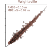
 Model performance is evaluated across tens of thousands of test tiles spanning the full range of coastal settings and flood responses. The surrogate achieves an overall root-mean-square error (RMSE) = 0.2722 m and maintains strong accuracy across the critical 0 m to 3 m elevation range that governs inundation onset, shoreline overtopping, and inland flood propagation. Elevation-dependent analyses reveal predictable patterns: highest accuracy in persistently dry uplands, moderate accuracy in shallow-water transition zones where small vertical differences strongly influence flooding, and larger errors in sparsely sampled or highly nonlinear regions such as tidal channels. Tile‑level case studies further show how storm approach angle, intensity, and local geomorphology shape prediction fidelity — parallel approaching storms over barrier islands produce larger errors due to enhanced alongshore gradients, whereas perpendicular tracks yield cleaner cross‑shore forcing that the model captures more reliably. These results highlight both the model’s strengths in reproducing coherent surge patterns and its limitations in regions with complex hydrodynamics or limited training representation.
By predicting a map of storm tide in milliseconds, this model enables a framework for real-time hazard assessment, which can be scaled to other coastlines. This model demonstrates that neural-network surrogates can reproduce the essential physics of storm-tide dynamics and be useful during storms.
ME McKenna (2026). “Deep Learning-Based Prediction of Coastal Tide Flood Maps.” North Carolina State University.


 The accuracy of atmospheric forcing is a critical component for total water level (TWL) prediction and coastal flood management during hurricanes. In this study, three classes of atmospheric inputs, parametric (Holland Model; HM), physics-based models (ECMWF-ERA5, Global Forecast System (GFS), and North American Mesoscale Forecast System (NAM)), and blended (HM+Physics-based), were evaluated during Hurricane Michael (October 2018) in the northeast Gulf of America (GoA). Simulations with and without wave coupling were carried out using Delft3D FM to quantify the contribution of wave-induced forces to TWL and flooding at Tyndall Air Force Base (TAFB) and Mexico Beach. HM captures the hurricane core winds, but underpredicts the far-field winds, whereas the physics-based models underestimate winds >20 m/s by over 50%. Blended forcing rectifies these biases with a decreased normalized root-mean-square error in TWL to as low as 0.05, with NAM-based blending outperforming ERA5- and GFS-based approaches due to a finer (∼12 km) spatial resolution. The physics-based models underpredicted the peak significant wave height (SWH), while the HM model overpredicted peak and underpredicted smaller SWHs. The blended models balanced these errors, enabling Delft3D FM (D-Waves) to reproduce large and small SWHs and to capture the 1D/2D spectra observed west of the hurricane track, with minor energy bias linked to phase shift. Overall, blending high-resolution physics-based with parametric core winds improves surge-wave prediction accuracy. While spatial resolution primarily controls blending skill, efficiency is region-dependent and event-specific. The necessity of blending remains sensitive to the nonlinear interaction between storm intensity, size, track, and geographic location.
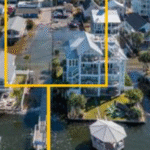
 An increase in commercial shipping has led to an increase in hazards for ship strikes on bridges, to which we refer as allisions. There is a need for a better understanding of how ships are affected by local flows as they approach an allision. We couple region- and local-scale models to simulate the allision of the container ship Dali with the Key Bridge. Simulations are forced with real tides, river inflows, and atmospheric conditions, and then the ship’s motion is predicted as it drifted and then allided with the bridge’s south pier. The trajectory is a close match to observations, and the allision timing is matched within 70 seconds of the real event. The ship’s southward turn was driven by a cross-channel gradient of 0.22 cm/s in the currents. Perturbations show the trajectory sensitivity to ship and environmental conditions, with many scenarios showing ship motion away from the bridge pier, as much as 500-m down-channel or 200-m to the north side. Simulations with wreckage show the depth-averaged currents may have increased by 10 to 20 cm/s in the temporary alternate channels around the bridge. Our findings can inform models for ship motion and management of navigation channels.
 Storm tides — the combination of tides and storm surge — cause flooding in coastal regions, often with differences in magnitudes between the open coast and locations within water bodies like bays and estuaries. Previous studies have shown that storm surge is sensitive to the storm’s wind intensity, speed, and track; the coast’s geometry and relative position to the storm; and also to nonlinear interactions with tides. These sensitivities have been documented at either open coast or bay locations, but without comparing or quantifying the differences in behavior between them, even though these differences may have implications for risk management. This study examines the range of peak storm tides within the Lower Chesapeake Bay, which has vulnerable communities at the open coast, like Virginia Beach, and inside the bay near the James River, like Hampton and Norfolk. A high‐resolution model was developed for the region and validated against observations of water levels during Hurricane Irene in 2011. Storm parameters were perturbed to analyze the variation in storm tide ranges. It was found that the range of possible storm tides was greater at bay locations than at the open coast, by as much as 47%. This higher variability at the bay locations was due to sensitivities to storm parameters like the wind intensity and storm tracks, which led to storm tide peaks outside of the interquartile range. This finding highlights the importance of understanding the uncertainty in storm forecasts concerning future possible impacts in complex coastal regions.
 Storm-driven flooding is a hazard for coastal communities. Process-based models can predict the combined effects of tides, winds, and flooding due to tropical cyclones, including in real-time, but often with restrictions due to a model’s runtime. Researchers have developed neural networks (NN), trained on libraries of storm surge simulations, to predict flooding in seconds. However, previous NNs ignored interactions with astronomical tides, limited to storms of specific durations, and trained for extreme conditions.
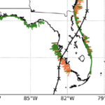
 Flooding due to storm surge can propagate through coastal regions to threaten the built and natural environments. This propagation is controlled by geographic features of varying scales, from the largest oceans to the smallest marsh channels and sandy dunes. Numerical models to predict coastal flooding have been improved via the use of subgrid corrections, which use information about the smallest-scale flow controls to provide corrections to coarser scale grids. Although previous studies have demonstrated the benefits of subgrid models, especially how coarser models can be more efficient without a trade-off in accuracy, this study systematically investigates subgrid corrections in storm surge models across large domains. Here, we apply the widely used ADVanced CIRCulation (ADCIRC) storm surge model with revised subgrid corrections to develop guidance for resolution of coastal regions. Recent hurricanes in the South Atlantic Bight are simulated with five models, each with varying resolution of coastal islands, estuaries, rivers, and floodplains. Model performance is quantified via comparisons with observed data and high-resolution simulations. Clear degradation is observed in the subgrid model performance as minimum mesh resolution becomes coarser than the width of channels conveying flow or the barrier islands blocking flow. Therefore, subgrid model mesh resolution should account for spatial scales of local flow pathways and barrier islands to maintain proper model mass and momentum transfer. However, with subgrid modeling this can be done at much coarser (and thus computationally faster) resolutions than with conventional models.
 As sea levels continue to rise, coastal communities are searching for strategies to reduce flooding of low-lying roads, property, and stormwater drainage networks. Here we focus on the development of adaptation strategies for communities that experience flooding outside of extreme storms like hurricanes due to sea level rise (SLR). Processes that contribute to these floods can include tides, rainfall, wind setup, groundwater, and infrastructure failure (Gold et al., 2023). Here we present a framework to test the effectiveness of adaptation strategies in reducing multi-driver chronic flooding at both current and future sea levels. This framework integrates coastal engineering and stakeholder input to 1) identify adaptation strategies that are preferred by a community that frequently floods and 2) test the effectiveness of these strategies with a numerical model under both current and future conditions.
 The U.S. Atlantic and Gulf of Mexico coasts are vulnerable to storms, which can cause significant erosion of beaches and dunes that protect coastal communities. Real-time forecasts of storm-driven erosion are useful for decision support, but they are limited due to demands for computational resources and uncertainties in dynamic coastal systems and storm forcings. Current methods for coastal change forecasts are based on empirical calculations for wave run-up and conceptual models for erosion, which do not represent sediment transport and morphological change during the storm. However, with continued advancements in high-resolution geospatial data and computational efficiencies, there is an opportunity to apply morphodynamic models for forecasts of beach and dune erosion as a storm approaches the coast. In this study, we implement a forecast system based on a deterministic, dynamic model. The morphodynamic model is initialized with digital elevation models of the most up-to-date conditions and forced with hydrodynamics from wave and circulation model forecasts, and its predictions are categorized based on impact to the primary dune, defined in this study as the first ridge of sand landward of the beach. Results are compared spatially to the observed post-storm topography using changes to dune crest elevations and volumes, and temporally to the predicted total water level at the forecasted moment of dune impact.