Coastal areas are subjected to storms and subsequent erosion and flooding. Waves and storm surge can cause damage to infrastructure and short- and long-term changes to coastal morphology. These morphodynamic changes can range from mild beach erosion to severe dune removal, overwash, and breaching. In this dissertation, a combination of models are used to explore the storm-driven hydro- and morphodynamic processes on different scales and their interactions over time. Additionally, their application is extended for prediction of beach response to sea-storms by coupling deterministic and probabilistic models.
 In this dissertation, first a morphodynamic model is used to explore the effects of Isabel (2003) on the NC Outer Banks, with the focus on a large domain that covers 30 km of the barrier island from Rodanthe to Avon. It is hypothesized that the model can be coarsened and expanded to a large domain while preserving accuracy. Model predictions for dune erosion and overwash are in good agreement with post-storm observations. Sensitivity studies show that the model accuracy is less sensitive to the alongshore resolution of the mesh. Then, the topographic elevation changes are upscaled to a region-scale flooding model to allow overwash and inundation behind the dunes. The loose coupling of these process-based models improves the flooding predictions in region-scale model significantly.
 Then, a more complex case of beaching and its impacts on larger-scale circulations are explored. Isabel (2003) breached the barrier island near the town of Hatteras and formed three channels connecting the ocean to the sound. Two-way coupling of high-resolution numerical models for coastal erosion and flooding is implemented to study the temporal and spatial evolution of the breach and its contribution to the hydrodynamics in the sound. It is hypothesized that the channels were formed due to the combined effects of ocean-side dune erosion and lagoon-side elevated water levels. The model shows that the flow from the sound to the ocean has an important role in deepening the breached channels. The morphodynamic model can predict the initiation and approximate location of the breach. However, it failed to accurately capture the channels’ depths. Several flooding scenarios are considered to implement the ground surface changes in the flooding model. The evolving breach can affect the timing and extent of flow into the lagoon. The model results show that the breach has region-scale effects on flooding that extend about 10 km into the lagoon.
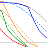 Finally, the erosion of nourished beaches subjected to multiple storms is investigated. Beach nourishment provides a buffer during extreme events in the short-termbut has a finite lifespan as the beach responds to subsequent storms. Numerical models are widely used to predict the beach morphodynamics, however, they are computationally expensive. In this research, a surrogate model is developed by coupling deterministic and probabilistic models to improve the computational efficiency and to include the randomness of possible future scenarios. A large data set of storm data and beach profiles is used to create a library of thousands of hypothetical scenarios to train the surrogate model. It is hypothesized that adding the beach profile variability in the analysis can improve the model in the sense that it can be applied to any beach state. The results show that predicted erosion volume by the surrogate model is very close to the numerical model predictions. The model produced the results in a few seconds which shows a significant improvement in computational time compared to numerical models.
This research has the potential to improve the prediction of storm-driven erosion, overwash, inundation and breaching. The loose coupling of hydro- and morphodynamic models allows for better predictions of storm-driven flooding into previously protected areas, such as coastal communities and back-barrier regions. The use of observed beach profiles in the development of a surrogate model can improve its predictions of nourishment response to single and successive storms. These better predictions can enable better planning and design for mitigation of future hazards.
A Gharagozlou (2021). “Coupling of Deterministic and Probabilistic Models for Prediction of Storm-Driven Erosion on Barrier Islands,” North Carolina State University.


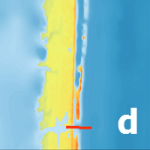
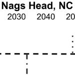
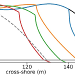 Dunes and beaches are vulnerable to erosion during storm events. Numerical models can predict beach response to storms with fidelity, but their computational costs, the domain-specific knowledge necessary to use them, and the wide range of potential future storm and beach conditions can hinder their use in forecasting storm erosion for short- and long-term horizons. We develop an emulator, which is an efficient predictive model that behaves like a numerical model, to predict the morphologic response of the subaerial beach to storms. Specific emphasis is placed on providing antecedent beach states as an input to the emulator and predicting the post-storm profile shape. Training data include beach profiles at multiple stages in a nourishment life cycle to assess if such a framework can be applied in locations that nourish as a coastal defense policy. Development and application of the emulator is focused on Nags Head, North Carolina, which nourishes its beaches to mitigate hazards of storm waves, flooding, and erosion. A high-fidelity, process-based morphodynamic model is used to train the emulator with 1250 scenarios of sea-storms and beach profiles. The post-storm beach state is emulated with a parameterized power-law function fit to the eroded portion of the subaerial profile. When the emulator was tested for a sequence of real storms from 2019, the eroded beach profiles were predicted with a skill score of 0.66. This emulator is promising for future efforts to predict storm-induced beach erosion in hazard warnings or adaptation studies.
 Coastal communities throughout the world will be faced with policy decisions that affect their resilience to climate change, sea level rise, and associated impacts. Adaptation pathways, a holistic approach to policy development, may be an ideal framework for municipalities to consider in low-lying, dynamic environments such as barrier islands. Adaptation pathways identify hypothetical future timelines whereby communities adopt a different policy in response to new environmental conditions. This takes into account changing conditions and resulting hazards that exceed a threshold agreed upon by the community. In this paper, we focus on barrier island communities and give an overview of adaptation pathway methodologies, highlight several common policies considered to increase resilience, review how coastal scientists have thus far contributed to such methods, and discuss specific research agendas that could aid in future implementations. Although the use of adaptation pathways is still in its early stages in many coastal communities, the success of the process is dependent on contributions from both quantitative hazard research and consistent engagement with stakeholders in an iterative co-development of prioritized policy trajectories. Scientific needs include: better understanding of future hazards due to climate change and sea level rise, better predictions of time-dependent processes such as barrier island response to human alterations to natural coastal defense systems, and improved communication between physical scientists, social scientists, managers, and stakeholders.