Storm-driven flooding is a hazard for coastal communities. Process-based models can predict the combined effects of tides, winds, and flooding due to tropical cyclones, including in real-time, but often with restrictions due to a model’s runtime. Researchers have developed neural networks (NN), trained on libraries of storm surge simulations, to predict flooding in seconds. However, previous NNs ignored interactions with astronomical tides, limited to storms of specific durations, and trained for extreme conditions.
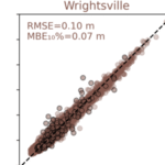
In this study, a NN is developed to predict peak values for storm tides (storm surge and tides) at nine stations along the North Carolina coast. For training, a library of storm-tides was developed via process-based model simulations of 1,813 synthetic storms based on historical data in the north Atlantic Ocean, but with a specific focus on North Carolina, and then augmented by a factor of 50 via combinations with random tides. Unlike previous NN, this approach incorporates the astronomical tides in the training and uses data augmentation techniques for enhanced generalization. The NN performs well, with root-mean-square errors of about 6 cm and mean bias errors for the extreme storms of about 5 cm. For probabilistic predictions of historical storms, the model can predict for 100 ensemble members in 1 sec, and the ranges of peak storm tides are close to their true values.
TA Cuevas López, BJ Tucker, JC Dietrich, DL Anderson, E Lobaton, JS Mariegaard (2025). “Neural Network Predictions of Peak Storm Tides due to Tropical Cyclones.” Ocean Modelling, 197, 102588, DOI: 10.1016/j.ocemod.2025.102588.


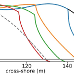 Dunes and beaches are vulnerable to erosion during storm events. Numerical models can predict beach response to storms with fidelity, but their computational costs, the domain-specific knowledge necessary to use them, and the wide range of potential future storm and beach conditions can hinder their use in forecasting storm erosion for short- and long-term horizons. We develop an emulator, which is an efficient predictive model that behaves like a numerical model, to predict the morphologic response of the subaerial beach to storms. Specific emphasis is placed on providing antecedent beach states as an input to the emulator and predicting the post-storm profile shape. Training data include beach profiles at multiple stages in a nourishment life cycle to assess if such a framework can be applied in locations that nourish as a coastal defense policy. Development and application of the emulator is focused on Nags Head, North Carolina, which nourishes its beaches to mitigate hazards of storm waves, flooding, and erosion. A high-fidelity, process-based morphodynamic model is used to train the emulator with 1250 scenarios of sea-storms and beach profiles. The post-storm beach state is emulated with a parameterized power-law function fit to the eroded portion of the subaerial profile. When the emulator was tested for a sequence of real storms from 2019, the eroded beach profiles were predicted with a skill score of 0.66. This emulator is promising for future efforts to predict storm-induced beach erosion in hazard warnings or adaptation studies.