

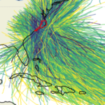
 This thesis develops an artificial intelligence (AI) model to predict peak storm-tides as flood maps with sufficient detail to describe hazards at community scales. Unlike prior approaches that predict storm surge or storm tides at discrete points, this model generates continuous inundation maps that consider the geomorphic controls governing coastal flooding. This model is trained on a library of process-based model simulations spanning a realistic range of storm intensities, forward speeds, track geometries, and landfall locations. Storm-tide maps are predicted for coastal North Carolina, which has a complex coastal region with narrow and wide shelves, barrier islands, inlets, sounds, estuaries, and extensive low-lying floodplains, and which is threatened by landfalling tropical cyclones.
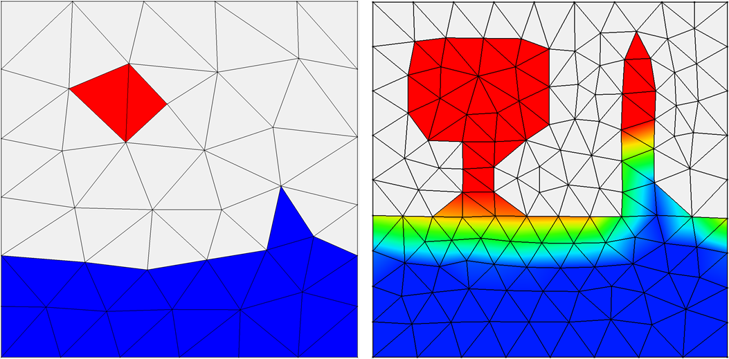
 A central methodological contribution of this work is a physics‑aware tiling and data-augmentation framework that restructures each full-domain simulation into a set of local storm-tide map tiles. Rather than treating each storm as a single, domain‑wide field, the augmentation extracts 64 non-overlapping map tiles (0.25º longitude by 0.25° latitude) that retain geospatial reference, coastal morphology, and hydrodynamic structure. This transformation allows the model to learn how individual storms affect specific regions of the coastline, rather than attempting to generalize across the entire domain at once. The model can see diverse, meaningful examples without introducing distortions from naive image‑based augmentation, expanding the effective training dataset by more than an order of magnitude. The neural‑network architecture fuses two complementary data streams — temporal storm evolution (track, intensity, motion) and static elevation maps encoding pre-storm geomorphology — and is trained using a staged Huber-loss strategy that refines spatial accuracy. Together, these components enable the AI model to learn localized storm‑tide responses while maintaining consistency with the underlying coastal physics.
 Model performance is evaluated across tens of thousands of test tiles spanning the full range of coastal settings and flood responses. The surrogate achieves an overall root-mean-square error (RMSE) = 0.2722 m and maintains strong accuracy across the critical 0 m to 3 m elevation range that governs inundation onset, shoreline overtopping, and inland flood propagation. Elevation-dependent analyses reveal predictable patterns: highest accuracy in persistently dry uplands, moderate accuracy in shallow-water transition zones where small vertical differences strongly influence flooding, and larger errors in sparsely sampled or highly nonlinear regions such as tidal channels. Tile‑level case studies further show how storm approach angle, intensity, and local geomorphology shape prediction fidelity — parallel approaching storms over barrier islands produce larger errors due to enhanced alongshore gradients, whereas perpendicular tracks yield cleaner cross‑shore forcing that the model captures more reliably. These results highlight both the model’s strengths in reproducing coherent surge patterns and its limitations in regions with complex hydrodynamics or limited training representation.
By predicting a map of storm tide in milliseconds, this model enables a framework for real-time hazard assessment, which can be scaled to other coastlines. This model demonstrates that neural-network surrogates can reproduce the essential physics of storm-tide dynamics and be useful during storms.
 In this research, we implemented a neural network to predict peak values for total water level (tides and storm surge) at multiple stations, considering astronomical tides and storm tracks of any duration as inputs. To create the training library, we simulated 1,813 synthetic tropical cyclones based on historical data in the North Atlantic Ocean, with a specific focus on storms that affect North Carolina. These simulations used a full-physics hydrodynamic model with variable spatial resolution of about 50 m near the coast. The outputs were downscaled to grayscale images with a higher and constant resolution of 15 m, enhancing the flood predictions by considering small-scale topographic features, and then used as training data for the neural network. The many-to-one deep learning model predicts a single peak total water level in time at multiple locations in space using time series of the offshore astronomical tide and track parameters as inputs. We used the model to make probabilistic predictions of peak total water levels for observed and perturbed tracks of several historical storms that affected North Carolina.
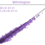 We showed that the neural network performed well (with errors ranging from 8 to 43 cm) in predicting peak total water levels at nine locations in North Carolina. We applied the neural network to make probabilistic predictions of peak total water levels for observed and perturbed tracks of historical storms. For each storm, the neural network predicted at nine stations for 101 storm scenarios (the true/historical storm and 100 perturbations) in less than 10 seconds. The performance for the observed historical storms was similar to those obtained in process-based simulations, but with a significant gain in computational runtime.
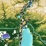 In this dissertation, subgrid corrections have been added to the ADvanced CIRCulation (ADCIRC) model, a widely used, continuous-Galerkin finite-element based, shallow water flow model. This includes the full derivation of averaged governing equations, closure approximations, and subgrid implementation into the source code. Testing of this new model was first performed on 3 domains: an idealized winding channel, a tidally influenced bay in Massachusetts, and a regional storm surge model covering Calcasieu Lake in Southwestern Louisiana with forcing from Rita (2005). By pre-computing the averaged variables from high-resolution bathy/topo data sets, the model can represent hydraulic connectivity at smaller scales. This allows for a coarsening of the model and thus faster predictions of flooding, while also improving accuracy. The implementation permits changing a logic-based wetting and drying algorithm to a more desirable logic-less algorithm, and requires averaging correction factors on both an elemental and vertex basis. This new framework further increases efficiency of the model, and is general enough to be used in other Galerkin-based, finite-element, hydrodynamic models. It is shown that the flooding model with subgrid corrections can match the accuracy of the conventional model, while offering a 10 to 50 times increase in speed.
 Next, higher level corrections to bottom friction and advection were incorporated into the subgrid model, and the framework was expanded and tested at the ocean-scale. It was hypothesized that by adding higher-level corrections to the model and applying them to ocean-scale domains, accurate predictions of storm surge at the smallest coastal scales can be obtained. To accomplish this, higher-level corrections were derived and implemented into the governing equations and extensive elevation and landcover data sets were curated to cover the South Atlantic Bight region of the U.S. Atlantic Coast. From there, the subgrid model was tested on an ocean-scale domain with tidal and meteorological forcing from Matthew (2016). The improvements in water level prediction accuracy due to subgrid corrections are evaluated at 218 observation locations throughout 1500 km of coast along the South Atlantic Bight. The accuracy of the subgrid model with relatively coarse spatial resolution (RMSE = 0.41 m) is better than that of a conventional model with relatively fine spatial resolution (RMSE = 0.67 m).By running on the coarsened subgrid model, we improved the accuracy over efficiency curve for the model, and as a result the computational expense of the simulation was decreased by a factor of 13.
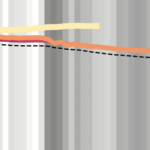 Finally, subgrid corrections were systematically tested on a series of five ocean-scale meshes with minimum nearshore resolutions ranging from around 60 m on the highest resolution mesh to 1000 m on the coarsest mesh. This study aimed to find the mesh resolution that offered the best trade-off between accuracy and efficiency. The limitations of the subgrid model were explored and guidelines for future users were established. In all, it was found that the primary limitation to the subgrid model came from the aliasing of important flow-blocking features such as barrier islands in the coarsest resolution meshes. However, in areas without these features subgrid corrections can offer tremendous advantages while running on very coarse meshes.
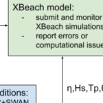 In this study, we apply the state-of-art model eXtreme Beach (XBeach) to predict coastal erosion due to Hurricanes Michael (2018) and Ian (2022). Sandy beaches along the U.S. Atlantic and Gulf coasts are represented with thousands of one-dimensional transects, which are sampled for real-time forecasts based on the storms’ tracks and projected landfall locations. The morphodynamic model is initialized with high-resolution digital elevation models of the present-day conditions and forced with hydrodynamics from high-resolution wave and circulation models, and its predictions are categorized based on impacts to the primary dune. A key contribution of this study is the semi-automation of the modeling system, so the modeling framework can be applied to different regions of the coast as the landfall location shifts.
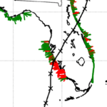 To demonstrate this, forecasts for Ian (2022) were initiated several days before the initial landfall location in Punta Gorda, Florida, and continued as the track made a secondary landfall near Georgetown, South Carolina. About 1800 transects are selected for each of the 25 advisories. The simulations are monitored, evaluated, and visualized to communicate the XBeach predictions of coastal change. The framework produces results in less than an hour and then publishes visualizations in less than 10 minutes. Results are compared spatially and temporally to qualitative post-Ian observations and total water level predictions. XBeach can predict dune impact compared to an established coastal change forecasting model while providing additional morphodynamic information not typically available, such as timing and magnitude of volume change. The addition of fully resolved ground surface information and morphodynamics in the model makes it possible to better understand the storm evolution and how that translates into erosion of beaches and dunes.
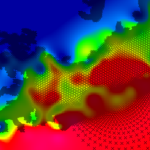 Numerical models can represent the coastal environment and its response to the combined effects of tides, river flows, and winds. It is especially challenging for numerical models to represent the response of estuaries to storms, due to the complex interactions of fresh and saline waters, and thus relatively few studies have used models to represent both storm- and density-driven circulation in estuaries. These few studies have shown that salinities and temperatures of estuaries can change significantly during storms and may require weeks to recover, depending on the amount of freshwater discharge. However, these studies have been limited in number and geographic coverage, relied on coupling to other models for baroclinic inputs, did not have the estuarine mixing and stratification as a focus, or were missing physics. Much is still uncertain about how estuarine circulation evolves during a storm event. How quickly do the horizontal salinities respond to the storm? How does the salinity transport vary through an estuary? How do freshwater discharges due to rainfall affect the mixing? Another uncertainty is the salinity response after the storm. How quickly does a system recover? Do the freshwater discharges interrupt the recovery? In this thesis, it is hypothesized that, for a large and shallow estuarine system with minimal connections to the open ocean, the storm forcing will cause large brackish and freshwater intrusions and recoveries that vary through the system.
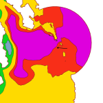 To investigate this hypothesis, we developed a three-dimensional model of storm- and density-driven circulation in the Albemarle-Pamlico Estuarine System (APES) in North Carolina. Irene (2011) was used as the basis for storm event simulations to examine the evolution of the horizontal salinity distribution. Included in this model were hurricane-strength winds and pressures, tides, river discharges, and density circulation. Using this model, it was determined that during Irene, APES experienced movements of brackish water into the estuaries and saline water into the sounds. These movements were heavily dependent on the winds. After the stormsimulation, the large river discharges produced intrusions of fresher water into major areas of the sound, and after two weeks, the system was not fully regulated.
 In this dissertation, first a morphodynamic model is used to explore the effects of Isabel (2003) on the NC Outer Banks, with the focus on a large domain that covers 30 km of the barrier island from Rodanthe to Avon. It is hypothesized that the model can be coarsened and expanded to a large domain while preserving accuracy. Model predictions for dune erosion and overwash are in good agreement with post-storm observations. Sensitivity studies show that the model accuracy is less sensitive to the alongshore resolution of the mesh. Then, the topographic elevation changes are upscaled to a region-scale flooding model to allow overwash and inundation behind the dunes. The loose coupling of these process-based models improves the flooding predictions in region-scale model significantly.
 Then, a more complex case of beaching and its impacts on larger-scale circulations are explored. Isabel (2003) breached the barrier island near the town of Hatteras and formed three channels connecting the ocean to the sound. Two-way coupling of high-resolution numerical models for coastal erosion and flooding is implemented to study the temporal and spatial evolution of the breach and its contribution to the hydrodynamics in the sound. It is hypothesized that the channels were formed due to the combined effects of ocean-side dune erosion and lagoon-side elevated water levels. The model shows that the flow from the sound to the ocean has an important role in deepening the breached channels. The morphodynamic model can predict the initiation and approximate location of the breach. However, it failed to accurately capture the channels’ depths. Several flooding scenarios are considered to implement the ground surface changes in the flooding model. The evolving breach can affect the timing and extent of flow into the lagoon. The model results show that the breach has region-scale effects on flooding that extend about 10 km into the lagoon.
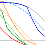 Finally, the erosion of nourished beaches subjected to multiple storms is investigated. Beach nourishment provides a buffer during extreme events in the short-termbut has a finite lifespan as the beach responds to subsequent storms. Numerical models are widely used to predict the beach morphodynamics, however, they are computationally expensive. In this research, a surrogate model is developed by coupling deterministic and probabilistic models to improve the computational efficiency and to include the randomness of possible future scenarios. A large data set of storm data and beach profiles is used to create a library of thousands of hypothetical scenarios to train the surrogate model. It is hypothesized that adding the beach profile variability in the analysis can improve the model in the sense that it can be applied to any beach state. The results show that predicted erosion volume by the surrogate model is very close to the numerical model predictions. The model produced the results in a few seconds which shows a significant improvement in computational time compared to numerical models.
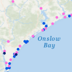 One of the most unpredictable and deadly parts of a coastal storm is the storm surge, which can cause devastating flooding of coastal regions, and can result in loss of property and life. Storm surge is a result of winds pushing water from the nearshore ocean to rise above regular tide levels. Storm surge can have a short duration; elevated water levels are limited to when the storm winds are strongest at the coast, typically for a few hours as the storm makes landfall. This short duration is a challenge for predictions of when storm surge will start, how long it will persist, and which regions will be flooded.
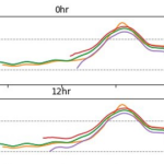 This research will explore the arrival of storm effects for Florence, which made landfall along the North Carolina coast during September 2018. It is an ideal storm for this research as its track was shore-normal, and thus its coastal effects increased as it approached landfall. This will allow for investigating the most optimal switch by focusing on a single switch between a lower-resolution mesh to a higher-resolution mesh. The switches will be initiated by several triggers, including wind speeds and water levels at the coast and inland locations, and with several lead times, including near and several days before landfall. Model performance will be quantified via comparisons to observations of storm effects in the region, as well as to a single, high-resolution simulation for the full storm. It will be shown that switching from a coarse resolution mesh to a fine resolution mesh will lead to an increase in efficiency gains across all switching simulations with the most optimal switch time resulting in the most accurate predictions of water levels as compared to our full high-resolution simulation.
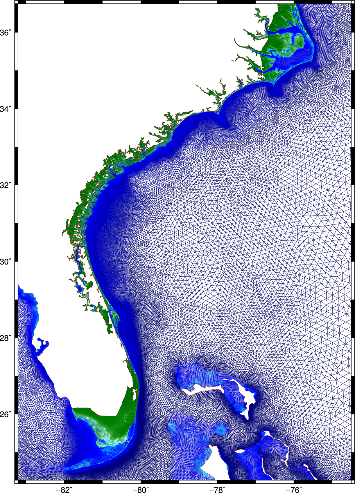 This research describes a method to improve the accuracy and efficiency of coastal flooding predictions. First, an existing model is used to explore the effect of storm forward speed and timing on tides and storm surge during Hurricane Matthew (2016). It is hypothesized that the spatial variability of Matthew’s effects on total water levels is due to the surge interacting nonlinearly with tides. If the storm occurred a few hours earlier or later, then the largest surges would have been shifted to other regions of the U.S. southeast coast. A change in forward speed of the storm also should alter its associated flooding due to differences in the duration over which the storm impacts the coastal waters. If the storm had moved faster, then the peak water levels would have increased along the coast, but the overall volume of inundation would have decreased. Then this research explores ways to increase the model’s accuracy and efficiency. To better represent Matthew’s effects, a mesh with detailed coverage of the coastal regions from Florida to North Carolina was developed by combining regional meshes originally developed for floodplain mapping. Compared to predictions using the earlier model, the new mesh allows for simulations of inundation that better match to observations especially inland.
 Then, to best utilize this new mesh, a multi-resolution approach is implemented to use meshes of varying resolution when and where it is required. It is hypothesized that by `switching’ from coarse- to fine-resolution meshes, with the resolution in the fine mesh concentrated only at specific coastal regions influenced by the storm at that point in time, both accuracy and computational gains can be achieved. As the storm approaches the coastline and the landfall location becomes more certain, the simulation will switch to a fine-resolution mesh that describes the coastal features in that region. Application of the approach during Hurricanes Matthew and Florence revealed the predictions to improve in both accuracy and efficiency, as compared to that from single simulations on coarse- and fine-resolution meshes, respectively.