

 During major storm events such as hurricanes, emergency managers rely on fast and accurate forecasting models to make important decisions concerning public safety. These models can be computationally costly and cannot quickly make predictions at the highest geospatial resolution. However, model output can be post-processed to mimic high-resolution results with minimal additional computational cost. This research proposes methods for improvement in the accuracy of downscaling (enhancing the resolution of) a real-time storm surge forecasting model. Such improvements to downscaling methods include 1) expansion in its spatial applicability, 2) adding physics using water surface slopes, and 3) adding physics using friction losses across the ground surface.
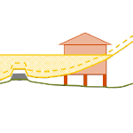
This research builds upon a process that uses maximum water elevation output from the Advanced Circulation (ADCIRC) model and downscales these results to a finer resolution by extrapolating the water levels to small-scale topography. This downscaling process is referred to as the static method. The method was originally designed for use in North Carolina (NC), where results from an ADCIRC model designed specifically for NC were downscaled to a set of NC topographical data. By joining the static method with an ADCIRC output visualization tool, the downscaling process is now able to run faster with the same level of accuracy and can run on any ADCIRC model with downscaling data from any geographical region or given resolution. This process is used to provide extra guidance to emergency managers and decision makers during hurricanes.
 The downscaling process is also improved by adding physics using the slopes method and the head loss method. The slopes method incorporates the slopes of the water levels produced by ADCIRC, rather than only the value of the water level. By interpolating ADCIRC output water elevation points into a smooth surface, slopes of this surface can be used to influence the elevations of downscaled water levels. The head loss method adds friction loss due to variations in the ground surface based on land cover types and friction associated with each type. As water travels over any surface, head loss, or a loss in energy, occurs at different rates depending on the surface roughness. This rudimentary hydrologic principle is applied to increase the accuracy of the downscaling process at minimal cost. The downscaling methods are applied for results from an ADCIRC simulation used in real-time forecasting, and then compared with results from an ADCIRC simulation with 10 times more resolution in Carteret County, NC. The static method tends to over-estimate the flood extents, and the slopes method is similar. However, the head loss method generates a downscaled flooding extent that is a close match to the predictions from the higher-resolution, full-physics model.
By improving the accuracy of downscaling methods at minimal computational cost and expanding the applicability of these downscaling methods, these methods can be used by emergency managers to provide a better estimation of flooding extents while simulating storm events.
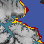
 The study begins with an application of a state-of-the-art storm surge model to examine the effects of meteorological forecast errors on coastal flooding predictions along the North Carolina (NC) coastline. As Hurricane Arthur (2014) moved over Pamlico Sound, it increased the total water levels to 2.5 m above sea level; this water pushed first into the river estuaries and against the inner banks, and then moved eastward to threaten the sound-side of the barrier islands. It is hypothesized that a combination of storm track and intensity errors caused errors in the forecast winds and water levels along the NC coast during Arthur. Model results reveal that, as the forecast storm track and intensity errors increase, the errors in forecast wind speeds also increase, but the errors in forecast water levels remain relatively the same, signifying the non-linear response of the coastal ocean to wind effects. By separating the forecast errors in storm track and storm strength, this study quantifies their effects on the coastal ocean, which provides useful guidance for designing relevant forecast ensembles.
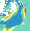
 In addition to flooding impacts, storms can also cause dramatic changes in estuarine salinities, which can negatively impact estuarine ecosystems. Baroclinic models are useful tools for predicting estuarine salinity response under changing environmental conditions. In the present work, the features of wind- and plume-driven circulation in the vicinity of Choctawhatchee Bay (CB) and Destin Inlet, Florida, are analyzed with a recently-enhanced, three-dimensional, baroclinic model. Satellite imagery showed a visible brackish surface plume at Destin during low tide. The goal of the present study is to quantify variability in the plume signature due to changes in tidal and wind forcing. Modeled tides, salinities and plume signature are validated against in-situ observations and satellite imagery and then applied to analyze plume response in two scenarios. In the first case, model plume behavior is analyzed on successive days of near-constant tidal amplitudes and changing wind directions due to passing cold fronts. In the second case, plume response is investigated during consecutive days of neap-spring variability in the tides and near-constant wind speeds. Model results reveal a larger plume during spring tides and periods of weak wind forcing. Oshore winds enhance the north-south expansion of the plume, whereas onshore winds restrict the plume to the coastline.
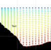 Finally, the validated model is applied to identify salinity and transport characteristics within CB. Based on past studies, it is hypothesized that CB is a stratified system with limited flushing and zones of distinct salinity gradients. These hypotheses are tested by analyzing bay salinities from the validated model during a period of low river flows. Model surface salinities indicate brackish conditions (20 psu) throughout the bay except for near the river mouth. Stratification (10 to 15 psu) within the bay is unaffected by the passage of cold fronts and neap-spring tidal variability. The residence time within the Choctawhatchee Bay, an important indicator of estuarine health, is computed via particle tracking and is equal to roughly 40 days.
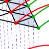 Coastal Louisiana and Mississippi are especially prone to large hurricanes due to their geographic location in the north-central Gulf of Mexico. Several recent hurricanes have devastated the region, creating complicated environments of waves and storm surge. Katrina (2005) and Gustav (2008) made landfall in southeastern Louisiana, and their counter-clockwise winds pushed surge onto the Louisiana-Mississippi continental shelf, into the low-lying wetlands surrounding the Mississippi River, and over and through the levee system that protects metropolitan New Orleans. Rita (2005) and Ike (2008) passed farther to the west, moved across the Texas-Louisiana continental shelf, and created surge that flooded large portions of southwestern Louisiana.
 Hydrodynamic models are used for a variety of purposes, such as the modeling of hurricane storm surges, the study of tidal circulation patterns, and the planning of naval fleet operations. One such hydrodynamic model is ADCIRC (ADvanced CIRCulation), which was developed more than 20 years ago and has been refined continuously by researchers across North America. ADCIRC is based on the shallow water equations and includes many of the features necessary to model complex hydrodynamic systems. However, some of these features were implemented in an attempt to solve specific problems, and their behaviors were never rigorously assessed. For instance, the model uses a wetting and drying algorithm to simulate the ebb and flow of tides in coastal regions. This behavior is important in many applications, and it must be modeled correctly. This research thesis will: (1) refute an attack on the usefulness of the finite volume method for computing mass balance errors, (2) lay the groundwork for a future study that will automate the placement of grid points based on a minimization of local mass balance error, (3) implement and assess the wetting and drying algorithm in one-, two-, and three-dimensional versions of the ADCIRC model, (4) identify a set of optimal parameters for wetting and drying simulations, (5) prove that recent updates to the wetting and drying algorithm were beneficial, and (6) show that smaller mass balance errors are obtained when they are computed for each vertical element in the water column.