 Storm-driven flooding is a hazard for coastal communities. Process-based models can predict the combined effects of tides, winds, and flooding due to tropical cyclones, including in real-time, but often with restrictions due to a model’s runtime. Researchers have developed neural networks (NN), trained on libraries of storm surge simulations, to predict flooding in seconds. However, previous NNs ignored interactions with astronomical tides, limited to storms of specific durations, and trained for extreme conditions.
In this study, a NN is developed to predict peak values for storm tides (storm surge and tides) at nine stations along the North Carolina coast. For training, a library of storm-tides was developed via process-based model simulations of 1,813 synthetic storms based on historical data in the north Atlantic Ocean, but with a specific focus on North Carolina, and then augmented by a factor of 50 via combinations with random tides. Unlike previous NN, this approach incorporates the astronomical tides in the training and uses data augmentation techniques for enhanced generalization. The NN performs well, with root-mean-square errors of about 6 cm and mean bias errors for the extreme storms of about 5 cm. For probabilistic predictions of historical storms, the model can predict for 100 ensemble members in 1 sec, and the ranges of peak storm tides are close to their true values.
 In this research, we implemented a neural network to predict peak values for total water level (tides and storm surge) at multiple stations, considering astronomical tides and storm tracks of any duration as inputs. To create the training library, we simulated 1,813 synthetic tropical cyclones based on historical data in the North Atlantic Ocean, with a specific focus on storms that affect North Carolina. These simulations used a full-physics hydrodynamic model with variable spatial resolution of about 50 m near the coast. The outputs were downscaled to grayscale images with a higher and constant resolution of 15 m, enhancing the flood predictions by considering small-scale topographic features, and then used as training data for the neural network. The many-to-one deep learning model predicts a single peak total water level in time at multiple locations in space using time series of the offshore astronomical tide and track parameters as inputs. We used the model to make probabilistic predictions of peak total water levels for observed and perturbed tracks of several historical storms that affected North Carolina.
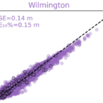 We showed that the neural network performed well (with errors ranging from 8 to 43 cm) in predicting peak total water levels at nine locations in North Carolina. We applied the neural network to make probabilistic predictions of peak total water levels for observed and perturbed tracks of historical storms. For each storm, the neural network predicted at nine stations for 101 storm scenarios (the true/historical storm and 100 perturbations) in less than 10 seconds. The performance for the observed historical storms was similar to those obtained in process-based simulations, but with a significant gain in computational runtime.