

Category Archives: DHS CRCoE 2016-2020
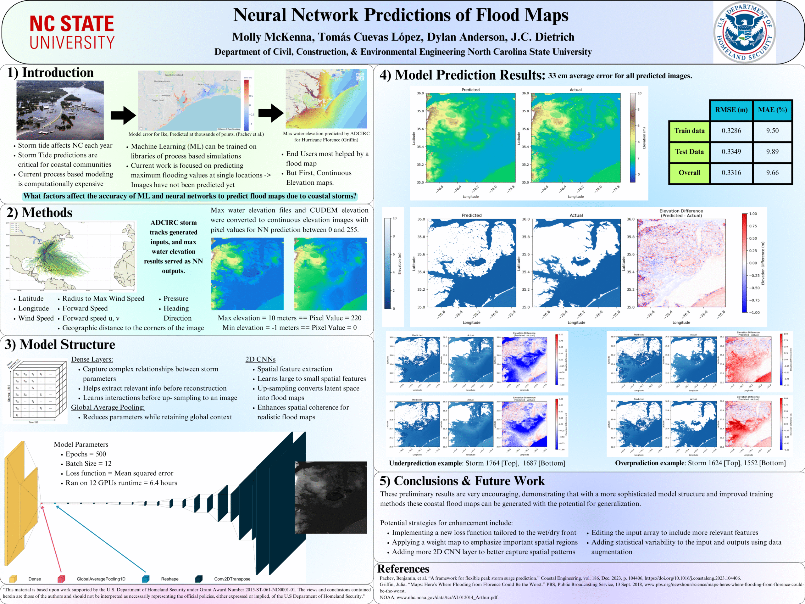
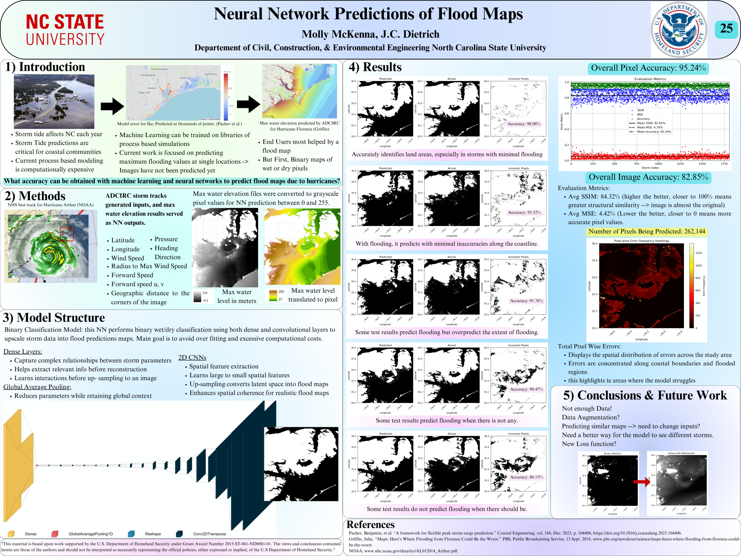
Deep Learning-Based Prediction of Coastal Tide Flood Maps
Coastal storm‑tide flooding arises from the interactions of storm surge, tides, and coastal geomorphology, and remains one of the most damaging hazards for low‑lying shorelines. Predicting the spatial extent and magnitude of storm‑tide inundation requires resolving nonlinear hydrodynamics and fine‑scale coastal features. However, high‑resolution process‑based models are expensive, limiting their use in applications that require rapid scenario evaluation or large ensembles. This motivates the development of fast, data‑driven surrogate models that can approximate storm‑tide behavior while retaining essential physics.
 This thesis develops an artificial intelligence (AI) model to predict peak storm-tides as flood maps with sufficient detail to describe hazards at community scales. Unlike prior approaches that predict storm surge or storm tides at discrete points, this model generates continuous inundation maps that consider the geomorphic controls governing coastal flooding. This model is trained on a library of process-based model simulations spanning a realistic range of storm intensities, forward speeds, track geometries, and landfall locations. Storm-tide maps are predicted for coastal North Carolina, which has a complex coastal region with narrow and wide shelves, barrier islands, inlets, sounds, estuaries, and extensive low-lying floodplains, and which is threatened by landfalling tropical cyclones.
 A central methodological contribution of this work is a physics‑aware tiling and data-augmentation framework that restructures each full-domain simulation into a set of local storm-tide map tiles. Rather than treating each storm as a single, domain‑wide field, the augmentation extracts 64 non-overlapping map tiles (0.25º longitude by 0.25° latitude) that retain geospatial reference, coastal morphology, and hydrodynamic structure. This transformation allows the model to learn how individual storms affect specific regions of the coastline, rather than attempting to generalize across the entire domain at once. The model can see diverse, meaningful examples without introducing distortions from naive image‑based augmentation, expanding the effective training dataset by more than an order of magnitude. The neural‑network architecture fuses two complementary data streams — temporal storm evolution (track, intensity, motion) and static elevation maps encoding pre-storm geomorphology — and is trained using a staged Huber-loss strategy that refines spatial accuracy. Together, these components enable the AI model to learn localized storm‑tide responses while maintaining consistency with the underlying coastal physics.
 Model performance is evaluated across tens of thousands of test tiles spanning the full range of coastal settings and flood responses. The surrogate achieves an overall root-mean-square error (RMSE) = 0.2722 m and maintains strong accuracy across the critical 0 m to 3 m elevation range that governs inundation onset, shoreline overtopping, and inland flood propagation. Elevation-dependent analyses reveal predictable patterns: highest accuracy in persistently dry uplands, moderate accuracy in shallow-water transition zones where small vertical differences strongly influence flooding, and larger errors in sparsely sampled or highly nonlinear regions such as tidal channels. Tile‑level case studies further show how storm approach angle, intensity, and local geomorphology shape prediction fidelity — parallel approaching storms over barrier islands produce larger errors due to enhanced alongshore gradients, whereas perpendicular tracks yield cleaner cross‑shore forcing that the model captures more reliably. These results highlight both the model’s strengths in reproducing coherent surge patterns and its limitations in regions with complex hydrodynamics or limited training representation.
By predicting a map of storm tide in milliseconds, this model enables a framework for real-time hazard assessment, which can be scaled to other coastlines. This model demonstrates that neural-network surrogates can reproduce the essential physics of storm-tide dynamics and be useful during storms.
Molly McKenna defends MS Thesis
Molly defended her MS thesis to an audience of faculty, students, and family members, who were very interested in her research on deep neural networks for predictions of coastal flood maps as raster images. Congrats to Molly!

Molly starting her thesis defense!
Thesis Defense: Molly McKenna
Posters: Fall 2025 Conferences
ME McKenna, TA Cuevas López, DL Anderson, JC Dietrich. Deep Learning-Based Prediction of Coastal Storm Tide Flood Maps. Applied AI in Engineering & Computer Science Symposium, North Carolina State University, Raleigh, North Carolina, 27 Oct 2025.

Deep Learning-Based Prediction of Coastal Storm Tide Flood Maps
Neural Network Predictions of Peak Storm Tides due to Tropical Cyclones
 Storm-driven flooding is a hazard for coastal communities. Process-based models can predict the combined effects of tides, winds, and flooding due to tropical cyclones, including in real-time, but often with restrictions due to a model’s runtime. Researchers have developed neural networks (NN), trained on libraries of storm surge simulations, to predict flooding in seconds. However, previous NNs ignored interactions with astronomical tides, limited to storms of specific durations, and trained for extreme conditions.
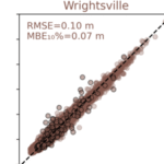
In this study, a NN is developed to predict peak values for storm tides (storm surge and tides) at nine stations along the North Carolina coast. For training, a library of storm-tides was developed via process-based model simulations of 1,813 synthetic storms based on historical data in the north Atlantic Ocean, but with a specific focus on North Carolina, and then augmented by a factor of 50 via combinations with random tides. Unlike previous NN, this approach incorporates the astronomical tides in the training and uses data augmentation techniques for enhanced generalization. The NN performs well, with root-mean-square errors of about 6 cm and mean bias errors for the extreme storms of about 5 cm. For probabilistic predictions of historical storms, the model can predict for 100 ensemble members in 1 sec, and the ranges of peak storm tides are close to their true values.
Posters: ADCIRC Users Meeting 2025
SG Lott, JC Dietrich, EL Seekamp, AJ Ross. “Modeling storm surge flooding for participatory transformation of barrier islands: Hatteras Island, NC, USA.” ADCIRC Users Group Meeting, Vicksburg, Mississippi, 12 May 2025.
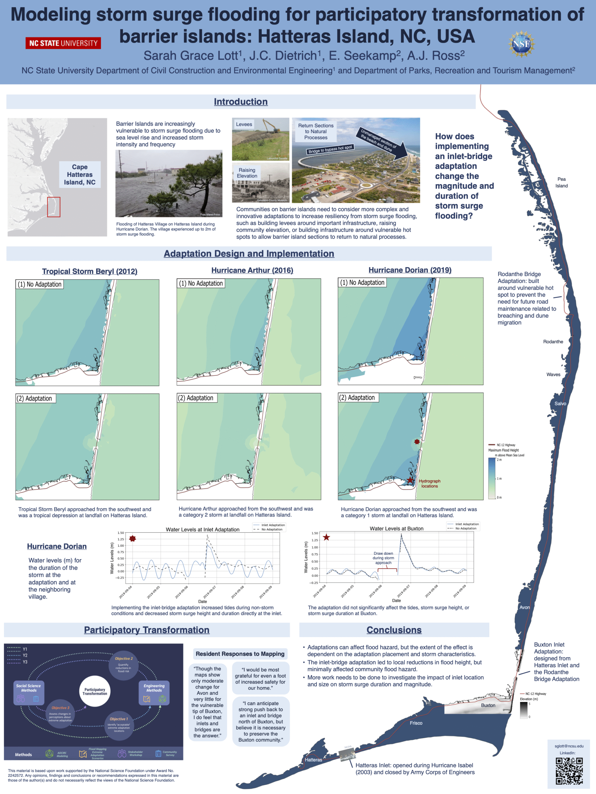
Modeling storm surge flooding for participatory transformation of barrier islands: Hatteras Island, NC, USA.
Neural Network Predictions of Flood Maps
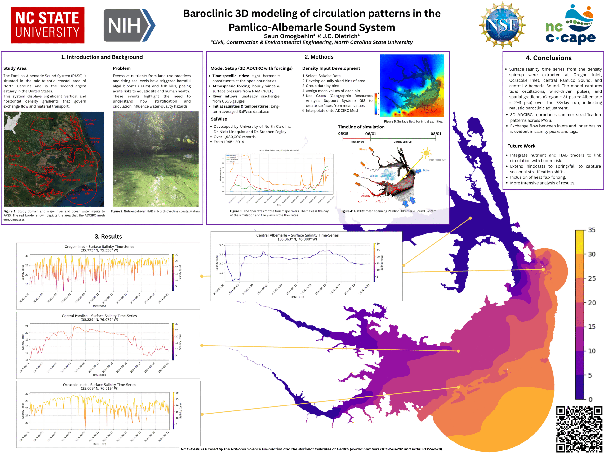
Baroclinic 3D modeling of circulation patterns in the Pamlico-Albemarle Sound System
Posters: EWC Symposium 2025
NK Arrigo, JC Dietrich, TC Massey. “Spatial controls and efficiency gains within a spectral wave model.” Environmental, Water Resources, and Coastal Engineering Graduate Research Symposium, North Carolina State University, 21 Mar 2025.
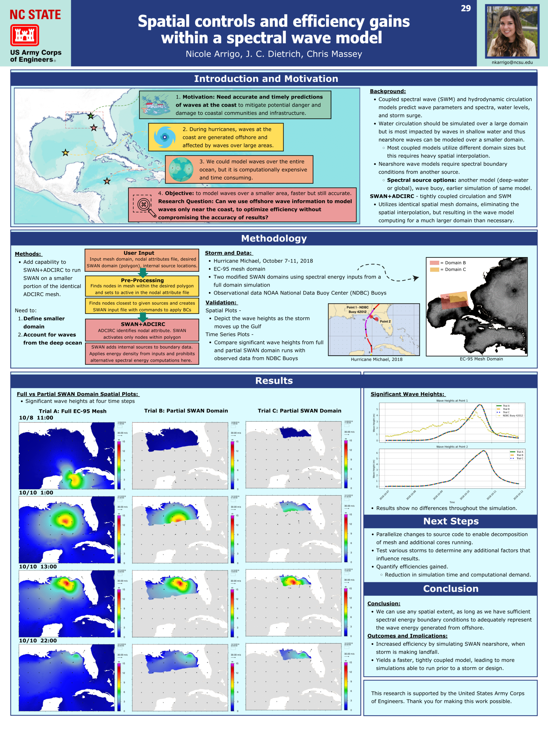
Spatial controls and efficiency gains within a spectral wave model.
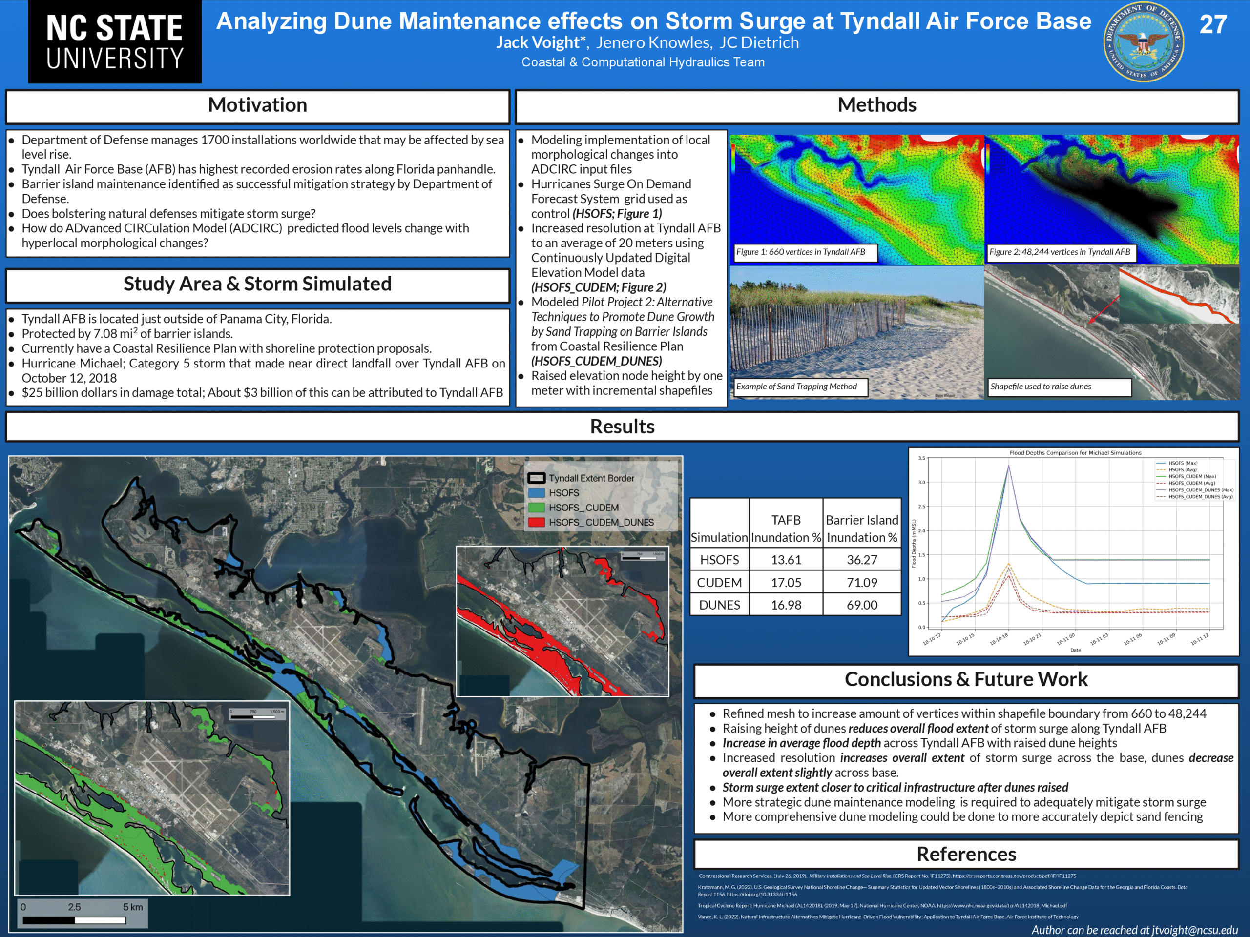
Analyzing Dune Maintenance effects on Storm Surge at Tyndall Air Force Base.
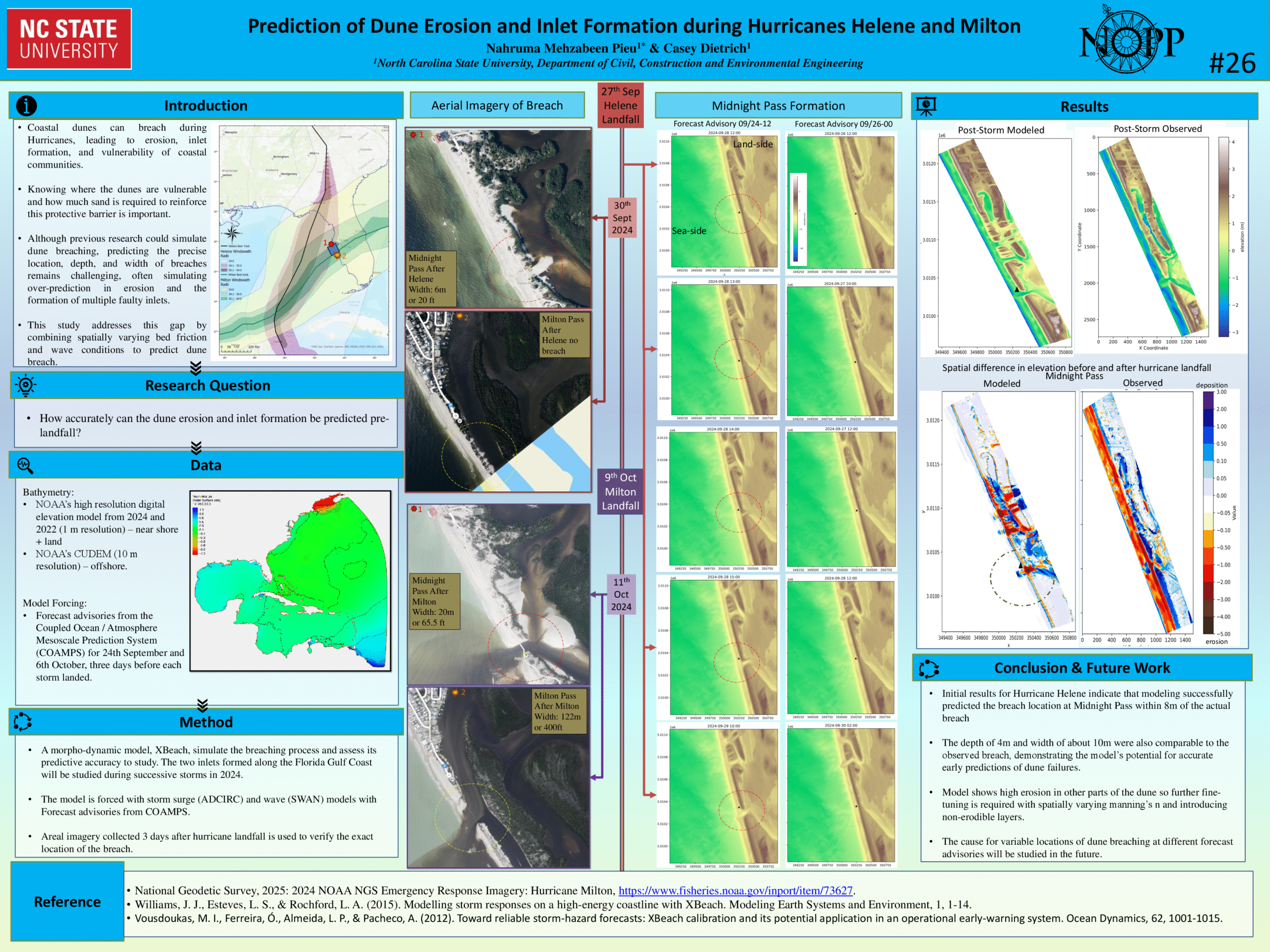
Prediction of Dune Erosion and Inlet Formation during Hurricanes Helene and Milton.
Neural Network Predictions of Flood Maps