 Barrier islands are susceptible to erosion, overwash, and breaching during intense storms. However, these processes are not represented typically in large-domain models for storm surge and coastal inundation. In this study, we explore the requirements for bridging the gap between dune-scale morphodynamic and region-scale flooding models. A high-resolution XBeach model is developed to represent the morphodynamics during Hurricane Isabel (2003) in the North Carolina (NC) Outer Banks. The model domain is extended to more than 30 km of Hatteras Island and is thus larger than in previous studies. The predicted dune erosion is in good agreement with post-storm observed topography, and an ‘‘excellent’’ Skill Score of 0.59 is obtained on this large domain. Sensitivity studies show the morphodynamic model accuracy is decreased as the mesh spacing is coarsened in the cross-shore direction, but the results are less sensitive to the alongshore resolution. A new metric to assess model skill, Water Overpassing Area (WOA), is introduced to account for the available flow pathway over the dune crest. Together, these findings allow for upscaled parameterizations of erosion in larger-domain models. The updated topography, obtained from XBeach prediction, is applied in a region-scale flooding model, thus allowing for enhanced flooding predictions in communities along the Outer Banks. It is found that, even using a fixed topography in region-scale model, the flooding predictions are improved significantly when post-storm topography from XBeach is implemented. These findings can be generalized to similar barrier island systems, which are common along the U.S. Gulf and Atlantic coasts.
Storm-Driven Erosion and Inundation of Barrier Islands from Dune- to Region-Scales
Barrier islands are susceptible to erosion, overwash, and breaching during intense storms. However, these processes are not represented typically in large-domain models for storm surge and coastal inundation. In this study, we explore the requirements for bridging the gap between dune-scale morphodynamic and region-scale flooding models. A high-resolution XBeach model is developed to represent the morphodynamics during Hurricane Isabel (2003) in the North Carolina (NC) Outer Banks. The model domain is extended to more than 30 km of Hatteras Island and is thus larger than in previous studies. The predicted dune erosion is in good agreement with post-storm observed topography, and an ‘‘excellent’’ Skill Score of 0.59 is obtained on this large domain. Sensitivity studies show the morphodynamic model accuracy is decreased as the mesh spacing is coarsened in the cross-shore direction, but the results are less sensitive to the alongshore resolution. A new metric to assess model skill, Water Overpassing Area (WOA), is introduced to account for the available flow pathway over the dune crest. Together, these findings allow for upscaled parameterizations of erosion in larger-domain models. The updated topography, obtained from XBeach prediction, is applied in a region-scale flooding model, thus allowing for enhanced flooding predictions in communities along the Outer Banks. It is found that, even using a fixed topography in region-scale model, the flooding predictions are improved significantly when post-storm topography from XBeach is implemented. These findings can be generalized to similar barrier island systems, which are common along the U.S. Gulf and Atlantic coasts.
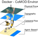 Tackling critical questions often requires the collaboration of researchers from different disciplines or institutions. Coastal hazards research is necessarily interdisciplinary and multi- methodological and often requires a team of researchers, due to its combination of storm-induced changes to the coastal environment, the effects of these changes on built infrastructure, and the combined effects on decision-making for individuals and communities. This paper introduces an interdisciplinary coastal hazard risk model that combines high resolution geospatial data, storm impact forecasts, and an agent-based model in the analysis, and then describes the model’s implementation in a data science cyberinfrastructure. Lessons learned and limitations are also outlined.