

Autumn Poisson defends MS Thesis
We gathered again virtually for a successful defense! With attendees from around the country, Autumn Poisson shared her research about the earliest signs of storm effects in coastal regions, and how they can be used to improve predictions of coastal flooding. She passed!

Autumn and her committee were happy with her performance.
Thesis Defense: Autumn Poisson
Dynamic Load Balancing for Predictions of Storm Surge and Coastal Flooding
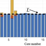 As coastal circulation models have evolved to predict storm-induced flooding, they must include progressively more overland regions that are normally dry, to where now it is possible for more than half of the domain to be needed in none or only some of the computations. While this evolution has improved real-time forecasting and long-term mitigation of coastal flooding, it poses a problem for parallelization in an HPC environment, especially for static paradigms in which the workload is balanced only at the start of the simulation. In this study, a dynamic rebalancing of computational work is developed for a finite-element-based, shallow-water, ocean circulation model of extensive overland flooding. The implementation has a low overhead cost, and we demonstrate a realistic hurricane-forced coastal flooding simulation can achieve peak speed-ups near 45% over the static case, thus operating now at 80−90% efficiency.
Downscaling of Real-Time Coastal Flooding Predictions for Decision Support
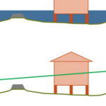 During coastal storms, forecasters and researchers use numerical models to predict the magnitude and extent of coastal flooding. These models must represent the large regions that may be affected by a storm, and thus, they can be computationally costly and may not use the highest geospatial resolution. However, predicted flood extents can be downscaled (by increasing resolution) as a post-processing step. Existing downscaling methods use either a static extrapolation of the flooding as a flat surface, or rely on subsequent simulations with nested, full-physics models at higher resolution. This research explores a middle way, in which the downscaling includes simplified physics to improve accuracy. Using results from a state-of-the-art model, we downscale its flood predictions with three methods: (1) static, in which the water surface elevations are extrapolated horizontally until they intersect the ground surface; (2) slopes, in which the gradient of the water surface is used; and (3) head loss, which accounts for energy losses due to land cover characteristics. The downscaling methods are then evaluated for forecasts and hindcasts of Hurricane Florence (2018), which caused widespread flooding in North Carolina. The static and slopes methods tend to over-estimate the flood extents. However, the head loss method generates a downscaled flooding extent that is a close match to the predictions from a higher-resolution, full-physics model. These results are encouraging for the use of these downscaling methods to support decision-making during coastal storms.
Proposal Defense: Johnathan Woodruff
Forecasting Coastal Impacts from Tropical Cyclones along the US East and Gulf Coasts using the ADCIRC Prediction System
To enhance the forecasting of wave, surge sediment transport (erosion and accretion above and below mean sea level), structure interaction and damage, we propose to heavily leverage our existing forecasting capability and experience operating the ADCIRC Prediction System (APS). We will enhance the current APS for surge, wave and inundation calculations, interface APS with the XBeach model to better represent nearshore and cross-shore wave processes and accompanying inundation and to predict sediment transport associated with the storm events. Wave and water level information from both APS and from XBeach will then be used to predict structure interaction and damage. Our efforts will focus on implementation and evaluation of our modeling system for hindcast events and/or for reanalysis of forecast events. Then we will utilize meteorological forcing to produce a daily forecast of coastal impacts beginning five days prior to landfall for at least three named hurricanes per year. These runs will be deterministic, commensurate with our approach to forecasting surge, wave and inundation from tropical cyclones in the APS. Given this experience, we are confident we will meet the forecast objectives of the NOPP community approach to model evaluation and improvement.
RA Luettich, MV Bilskie, BO Blanton, Z Cobell, DT Cox, JC Dietrich, JG Fleming, I Ginis. “Forecasting Coastal Impacts from Tropical Cyclones along the US East and Gulf Coasts using the ADCIRC Prediction System.” Department of Defense, Office of Naval Research, National Oceanographic Partnership Program (NOPP), Predicting Hurricane Coastal Impacts FY21-24, 2021/04/06 to 2025/04/05, $1,400,000 (Dietrich: $295,000).
Johnathan wins First Place in Student Presentation Competition
Ph.D. student Johnathan Woodruff won first place in the student presentation competition during the annual Environmental, Water Resources, and Coastal Engineering Research Symposium. This award is chosen by judges from among all of the student presentations and is reflective of both compelling research activities and excellent presentation skills. The award includes a $500 cash stipend.

Congratulations to Johnathan!
CCHT Ph.D. student Johnathan Woodruff.