

Webinar: USCRP In-Progress Review
Virtual Conference: ASBPA Coastal Conference 2020
Use of NetCDF-Formatted Wind Fields from OWI in ADCIRC
This new OWI file format was developed by Alex Crosby and his team at Oceanweather Inc. Most of the ADCIRC code to handle these new input files was implemented by Casey Dietrich.
ADCIRC has now been updated to allow the usage of NetCDF-formatted atmospheric fields from Oceanweather Inc. (OWI). In this new format, the surface pressure and wind fields have flexibility to represent different storms with different fields, to track storms with moving fields, and to vary resolution of the fields in both space and time. These updates have been added to the latest development version of ADCIRC, and they will be available in the next release version. These new fields are read by ADCIRC using the NWS=13 parameter and a new input file.
The following animation shows the use of this new file format in an ADCIRC simulation for the wind fields due to Hurricane Charley (1999). Note that Charley is one of several storms during this period, and each storm is represented by a moving field overlaid on a coarser background field.
In the rest of this page, we describe the new input file format, how it is used in ADCIRC, and then provide a set of example files.
Johnathan wins Student Educational Award
Ph.D. student Johnathan Woodruff won the Student Educational Award from the American Shore & Beach Preservation Association. This award is given annually to an undergraduate or graduate student who, through his or her research, is furthering the state of science of coastal systems as it relates to the goals and mission of the ASBPA. The award includes a $500 cash stipend. Johnathan wil attend the ASBPA National Coastal Conference next week to present his findings to the coastal community.

CCHT Ph.D. student Johnathan Woodruff.
Presentation: SECASC Coastal Resilience Working Group
Multihazard Hurricane Fragility Model for Wood Structure Homes Considering Hazard Parameters and Building Attribute Interaction
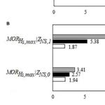 Predicting building damage as a function of hurricane hazards, building attributes, and the interaction between hazard and building attributes is a key to understanding how significant interaction reflects variation hazard intensity effect on damage based on building attribute levels. This paper develops multihazard hurricane fragility models for wood structure homes considering interaction between hazard and building attributes. Fragility models are developed for ordered categorical damage states (DS) and binary collapse / no collapse. Exterior physical damage and building attributes from rapid assessment in coastal Mississippi following Hurricane Katrina (2005), high-resolution numerical hindcast hazard intensities from the Simulating WAves Nearshore and ADvanced CIRCulation (SWAN+ADCIRC) models, and base flood elevation values are used as model input. Leave-one-out cross-validation (LOOCV) is used to evaluate model prediction accuracy. Eleven and forty-nine combinations of global damage response variables and main explanatory variables, respectively, were investigated and evaluated. Of these models, one DS and one collapse model met the rejection criteria. These models were refitted considering interaction terms. Maximum 3-s gust wind speed and maximum significant wave height were found to be factors that significantly affect damage. The interaction between maximum significant wave height and number of stories was the significant interaction term for the DS and collapse models. For every 0.3 m (0.98 ft) increase in maximum significant wave height, the estimated odds of being in a higher rather than in a lower damage state for DS model were found to be 1.95 times greater for one- rather than for two-story buildings. For every 0.3 m (0.98 ft) increase in maximum significant wave height, the estimated odds of collapse were found to be 2.23 times greater for one- rather than for two-story buildings. Model prediction accuracy was 84% and 91% for DS and collapse models, respectively. This paper does not consider the full hazard intensity experienced in Hurricane Katrina; rather, it focuses on single-family homes in a defined study area subjected to wind, wave, and storm surge hazards. Thus, the findings of this paper are not applicable for events with hazards that exceed those experienced in the study area, from which the models were derived.
Coastal Engineering Lab in Fitts-Woolard Hall
Construction is nearly-completed on Fitts-Woolard Hall, which will be our new home. We are moving slowly during this Fall 2020, and we will be in the new building when we return full-time to campus. The photo below is an updated look at our Coastal Engineering Lab. This room will have workspaces for the coastal engineering team at NC State, and its location on the third floor will allow a great view of Centennial Campus. We are excited for the new building!
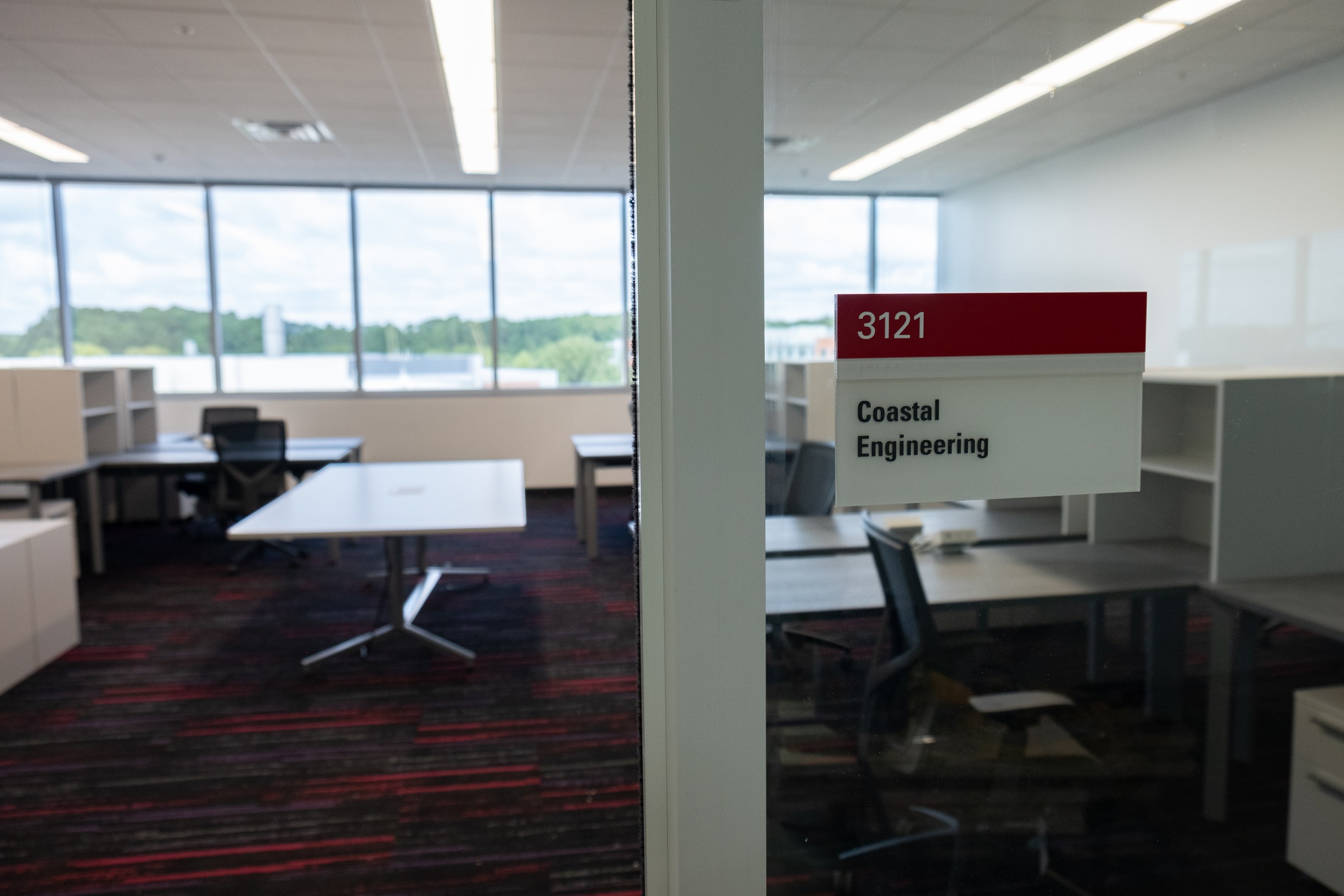
New glass wall and furniture for the lab.