

Category Archives: NSF PREEVENTS 2017-2021
Subgrid Surface Connectivity for Storm Surge Modeling
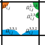 Subgrid modeling to account for unresolved topography within the context of shallow water equations relies on the use of coarse grids for computational efficiency. However, excessively coarse grids can lead to artificial cross flows between hydrologically disconnected areas separated by physical barriers smaller than the grid size. An approach based on introducing cell and edge clones, consisting of connected groups of pixels in each cell, is able to systematically remove such artificial cross flows. Such an approach considers that the subgrid barriers permanently divide flow among clones and effectively restrict flow to a predetermined path. In this work, a simple algorithm, along with the use of an overtopping formula, is proposed to extend the clone approach to a scenario in which clones are allowed to be further split and merged as needed, depending on the surface elevation during a given runtime. The algorithm is intended for accommodating the possibility of the subgrid barriers being inundated and no-longer dividing the flow during an extreme event. The performance of the proposed algorithm is demonstrated through a series of idealized and more realistic test cases, showing considerable improvements over existing methodologies.
Virtual Conference: SIAM Geosciences 2021
Downscaling of Real-Time Coastal Flooding Predictions for Decision Support
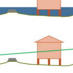 During coastal storms, forecasters and researchers use numerical models to predict the magnitude and extent of coastal flooding. These models must represent the large regions that may be affected by a storm, and thus, they can be computationally costly and may not use the highest geospatial resolution. However, predicted flood extents can be downscaled (by increasing resolution) as a post-processing step. Existing downscaling methods use either a static extrapolation of the flooding as a flat surface, or rely on subsequent simulations with nested, full-physics models at higher resolution. This research explores a middle way, in which the downscaling includes simplified physics to improve accuracy. Using results from a state-of-the-art model, we downscale its flood predictions with three methods: (1) static, in which the water surface elevations are extrapolated horizontally until they intersect the ground surface; (2) slopes, in which the gradient of the water surface is used; and (3) head loss, which accounts for energy losses due to land cover characteristics. The downscaling methods are then evaluated for forecasts and hindcasts of Hurricane Florence (2018), which caused widespread flooding in North Carolina. The static and slopes methods tend to over-estimate the flood extents. However, the head loss method generates a downscaled flooding extent that is a close match to the predictions from a higher-resolution, full-physics model. These results are encouraging for the use of these downscaling methods to support decision-making during coastal storms.
Proposal Defense: Johnathan Woodruff
Virtual Conference: EWC Symposium 2021
Virtual Conference: ASBPA Coastal Conference 2020
Johnathan wins Student Educational Award
Ph.D. student Johnathan Woodruff won the Student Educational Award from the American Shore & Beach Preservation Association. This award is given annually to an undergraduate or graduate student who, through his or her research, is furthering the state of science of coastal systems as it relates to the goals and mission of the ASBPA. The award includes a $500 cash stipend. Johnathan wil attend the ASBPA National Coastal Conference next week to present his findings to the coastal community.

CCHT Ph.D. student Johnathan Woodruff.