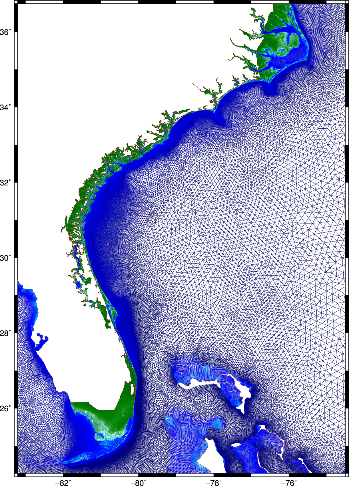
This research describes a method to improve the accuracy and efficiency of coastal flooding predictions. First, an existing model is used to explore the effect of storm forward speed and timing on tides and storm surge during Hurricane Matthew (2016). It is hypothesized that the spatial variability of Matthew’s effects on total water levels is due to the surge interacting nonlinearly with tides. If the storm occurred a few hours earlier or later, then the largest surges would have been shifted to other regions of the U.S. southeast coast. A change in forward speed of the storm also should alter its associated flooding due to differences in the duration over which the storm impacts the coastal waters. If the storm had moved faster, then the peak water levels would have increased along the coast, but the overall volume of inundation would have decreased. Then this research explores ways to increase the model’s accuracy and efficiency. To better represent Matthew’s effects, a mesh with detailed coverage of the coastal regions from Florida to North Carolina was developed by combining regional meshes originally developed for floodplain mapping. Compared to predictions using the earlier model, the new mesh allows for simulations of inundation that better match to observations especially inland.
 Then, to best utilize this new mesh, a multi-resolution approach is implemented to use meshes of varying resolution when and where it is required. It is hypothesized that by `switching’ from coarse- to fine-resolution meshes, with the resolution in the fine mesh concentrated only at specific coastal regions influenced by the storm at that point in time, both accuracy and computational gains can be achieved. As the storm approaches the coastline and the landfall location becomes more certain, the simulation will switch to a fine-resolution mesh that describes the coastal features in that region. Application of the approach during Hurricanes Matthew and Florence revealed the predictions to improve in both accuracy and efficiency, as compared to that from single simulations on coarse- and fine-resolution meshes, respectively.
Finally, the efficiency of the approach is further improved in the case of Hurricane Matthew, by using multiple smaller fine-resolution meshes instead of a single high-resolution mesh for the entire U.S. southeast coast. Simulations are performed utilizing predicted values of water levels, wind speeds, and wave heights, as triggers to switch from one mesh to another. Results indicate how to achieve an optimum balance between accuracy and efficiency, by using the above-mentioned triggers, and through a careful selection of the combination meshes to be used in the approach. This research has the potential to improve the storm surge forecasting process. These gains in efficiency are directly a savings in wall-clock time, which can translate into more time to invest in better models and/or more time for the stakeholders to consider the forecast guidance.
A Thomas (2020). “Using a Multi-Resolution Approach to Improve the Accuracy and Eficiency of Flooding Predictions,” North Carolina State University.


 Predicting building damage as a function of hurricane hazards, building attributes, and the interaction between hazard and building attributes is a key to understanding how significant interaction reflects variation hazard intensity effect on damage based on building attribute levels. This paper develops multihazard hurricane fragility models for wood structure homes considering interaction between hazard and building attributes. Fragility models are developed for ordered categorical damage states (DS) and binary collapse / no collapse. Exterior physical damage and building attributes from rapid assessment in coastal Mississippi following Hurricane Katrina (2005), high-resolution numerical hindcast hazard intensities from the Simulating WAves Nearshore and ADvanced CIRCulation (SWAN+ADCIRC) models, and base flood elevation values are used as model input. Leave-one-out cross-validation (LOOCV) is used to evaluate model prediction accuracy. Eleven and forty-nine combinations of global damage response variables and main explanatory variables, respectively, were investigated and evaluated. Of these models, one DS and one collapse model met the rejection criteria. These models were refitted considering interaction terms. Maximum 3-s gust wind speed and maximum significant wave height were found to be factors that significantly affect damage. The interaction between maximum significant wave height and number of stories was the significant interaction term for the DS and collapse models. For every 0.3 m (0.98 ft) increase in maximum significant wave height, the estimated odds of being in a higher rather than in a lower damage state for DS model were found to be 1.95 times greater for one- rather than for two-story buildings. For every 0.3 m (0.98 ft) increase in maximum significant wave height, the estimated odds of collapse were found to be 2.23 times greater for one- rather than for two-story buildings. Model prediction accuracy was 84% and 91% for DS and collapse models, respectively. This paper does not consider the full hazard intensity experienced in Hurricane Katrina; rather, it focuses on single-family homes in a defined study area subjected to wind, wave, and storm surge hazards. Thus, the findings of this paper are not applicable for events with hazards that exceed those experienced in the study area, from which the models were derived.

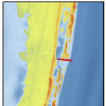 Barrier islands are susceptible to erosion, overwash, and breaching during intense storms. However, these processes are not represented typically in large-domain models for storm surge and coastal inundation. In this study, we explore the requirements for bridging the gap between dune-scale morphodynamic and region-scale flooding models. A high-resolution XBeach model is developed to represent the morphodynamics during Hurricane Isabel (2003) in the North Carolina (NC) Outer Banks. The model domain is extended to more than 30 km of Hatteras Island and is thus larger than in previous studies. The predicted dune erosion is in good agreement with post-storm observed topography, and an ‘‘excellent’’ Skill Score of 0.59 is obtained on this large domain. Sensitivity studies show the morphodynamic model accuracy is decreased as the mesh spacing is coarsened in the cross-shore direction, but the results are less sensitive to the alongshore resolution. A new metric to assess model skill, Water Overpassing Area (WOA), is introduced to account for the available flow pathway over the dune crest. Together, these findings allow for upscaled parameterizations of erosion in larger-domain models. The updated topography, obtained from XBeach prediction, is applied in a region-scale flooding model, thus allowing for enhanced flooding predictions in communities along the Outer Banks. It is found that, even using a fixed topography in region-scale model, the flooding predictions are improved significantly when post-storm topography from XBeach is implemented. These findings can be generalized to similar barrier island systems, which are common along the U.S. Gulf and Atlantic coasts.
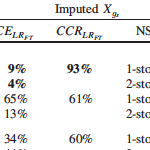 Missing building attributes are problematic for development of data-based fragility models. Relative to other disciplines, the application of imputation techniques is limited in the field of engineering. Current imputation techniques to replace missing building attributes lack evaluations of imputation model performance, which ensure accuracy and validity of the imputed data. This paper presents two imputation approaches, along with imputation diagnostic and comparison approaches, for binary building attribute data with missing observations. Predictive mean matching (PMM) and multiple imputation (MI) are used to impute foundation type and number of stories attributes. The diagnostic approach, based on the logistic regression goodness-of-fit test, is used to evaluate the imputation model fit. The comparison approach, based on the percentage of correctly imputed observations, is used to evaluate the imputation model performance. A data set of single-family homes damaged by the 2005 Hurricane Katrina is used to demonstrate implementation of the methodology. Based on the comparison approach, PMM models showed 9% and 2% greater accuracy than MI models in imputing foundation type and number of stories, respectively.