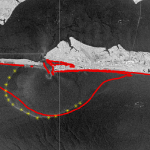
Multiple river-dominated estuaries line the northern Gulf coast and introduce substantial density variations. Their plumes have been shown to be highly sensitive to wind and tide effects, but in studies with limited observations and idealized wind forcing. This study explores these effects with a dynamic model that can represent the full behavior from river through estuary to shelf, and for a period with extensive observations. The inner shelf adjacent to Choctawhatchee Bay, a micro tidal estuary situated along the Florida Panhandle, is subject to buoyant, brackish outflows during the ebb-phase of the tidal cycle.
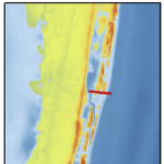
In December 2013, experiments were performed in this region to study mechanisms that influence near-shore surface transport. Satellite imagery showed a visible brackish surface plume at Destin during low tide. The goal of the present study is to quantify variability in the plume signature due to changes in tidal and wind forcing. Density-driven flows near Destin Inlet are modeled with the recently-enhanced, three-dimensional, baroclinic capabilities of the ADvanced CIRCulation (ADCIRC) model. Modeled tides, salinities and plume signature are validated against in-situ observations and satellite imagery. Model results reveal substantial changes in the length, width and orientation of the plume as the wind direction varied on consecutive days due to winter cold fronts. During a period of near-constant winds and variability in tidal amplitude, the model predicted a larger plume during spring tides than during neap conditions. Coriolis effects on the plume are minimized due to its small scale nature. Therefore, when the wind forcing is weak, the plume signature spreads radially from the inlet with slight preference to the down-shelf. The Choctawhatchee Bay plume is representative of other small-scale plumes formed in river-dominated and micro-tidal environments, and this work demonstrates the sensitivity of these plumes to changing environmental conditions.
R Cyriac, JC Dietrich, CA Blain, CN Dawson, KM Dresback, A Fathi, MV Bilskie, HC Graber, SC Hagen, RL Kolar (2019). “Wind and tide effects on the Choctawhatchee Bay plume and implications for surface transport at Destin Inlet.” Regional Studies in Marine Science, 35, 101131, DOI: 10.1016/j.rsma.2020.101131.


 Storm surge and coastal flooding predictions can require high resolution of critical flow pathways and barriers, typically with simulations using grids/meshes with millions of cells/elements to represent a coastal region. However, the cost of this resolution can slow forecasts during a storm. To add resolution when and where it is needed, previous studies have used adaptive mesh methods, which update resolution at single or multiple cells but which require hierarchies of and thresholds for refinement, and nesting methods, which update resolution at subdomains but which require additional simulations. This research proposes a middle way, in which predictions from a coarse mesh are mapped, mid-simulation, onto a fine mesh with increased resolution near the storm’s projected landfall location. The coarse and fine meshes are pre-developed, thus removing any refinement decisions during the simulation, the solution mapping uses a widely used framework, thus enabling an efficient interpolation, and the same simulation is continued, thus eliminating a separate full-domain simulation. For four historical storms, results show efficiency gains of up to 53 percent, with minimal accuracy losses relative to a static simulation.
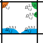 Subgrid modeling to account for unresolved topography within the context of shallow water equations relies on the use of coarse grids for computational efficiency. However, excessively coarse grids can lead to artificial cross flows between hydrologically disconnected areas separated by physical barriers smaller than the grid size. An approach based on introducing cell and edge clones, consisting of connected groups of pixels in each cell, is able to systematically remove such artificial cross flows. Such an approach considers that the subgrid barriers permanently divide flow among clones and effectively restrict flow to a predetermined path. In this work, a simple algorithm, along with the use of an overtopping formula, is proposed to extend the clone approach to a scenario in which clones are allowed to be further split and merged as needed, depending on the surface elevation during a given runtime. The algorithm is intended for accommodating the possibility of the subgrid barriers being inundated and no-longer dividing the flow during an extreme event. The performance of the proposed algorithm is demonstrated through a series of idealized and more realistic test cases, showing considerable improvements over existing methodologies.
 As coastal circulation models have evolved to predict storm-induced flooding, they must include progressively more overland regions that are normally dry, to where now it is possible for more than half of the domain to be needed in none or only some of the computations. While this evolution has improved real-time forecasting and long-term mitigation of coastal flooding, it poses a problem for parallelization in an HPC environment, especially for static paradigms in which the workload is balanced only at the start of the simulation. In this study, a dynamic rebalancing of computational work is developed for a finite-element-based, shallow-water, ocean circulation model of extensive overland flooding. The implementation has a low overhead cost, and we demonstrate a realistic hurricane-forced coastal flooding simulation can achieve peak speed-ups near 45% over the static case, thus operating now at 80−90% efficiency.
 During coastal storms, forecasters and researchers use numerical models to predict the magnitude and extent of coastal flooding. These models must represent the large regions that may be affected by a storm, and thus, they can be computationally costly and may not use the highest geospatial resolution. However, predicted flood extents can be downscaled (by increasing resolution) as a post-processing step. Existing downscaling methods use either a static extrapolation of the flooding as a flat surface, or rely on subsequent simulations with nested, full-physics models at higher resolution. This research explores a middle way, in which the downscaling includes simplified physics to improve accuracy. Using results from a state-of-the-art model, we downscale its flood predictions with three methods: (1) static, in which the water surface elevations are extrapolated horizontally until they intersect the ground surface; (2) slopes, in which the gradient of the water surface is used; and (3) head loss, which accounts for energy losses due to land cover characteristics. The downscaling methods are then evaluated for forecasts and hindcasts of Hurricane Florence (2018), which caused widespread flooding in North Carolina. The static and slopes methods tend to over-estimate the flood extents. However, the head loss method generates a downscaled flooding extent that is a close match to the predictions from a higher-resolution, full-physics model. These results are encouraging for the use of these downscaling methods to support decision-making during coastal storms.
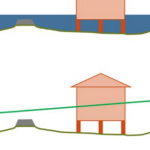
 Predicting building damage as a function of hurricane hazards, building attributes, and the interaction between hazard and building attributes is a key to understanding how significant interaction reflects variation hazard intensity effect on damage based on building attribute levels. This paper develops multihazard hurricane fragility models for wood structure homes considering interaction between hazard and building attributes. Fragility models are developed for ordered categorical damage states (DS) and binary collapse / no collapse. Exterior physical damage and building attributes from rapid assessment in coastal Mississippi following Hurricane Katrina (2005), high-resolution numerical hindcast hazard intensities from the Simulating WAves Nearshore and ADvanced CIRCulation (SWAN+ADCIRC) models, and base flood elevation values are used as model input. Leave-one-out cross-validation (LOOCV) is used to evaluate model prediction accuracy. Eleven and forty-nine combinations of global damage response variables and main explanatory variables, respectively, were investigated and evaluated. Of these models, one DS and one collapse model met the rejection criteria. These models were refitted considering interaction terms. Maximum 3-s gust wind speed and maximum significant wave height were found to be factors that significantly affect damage. The interaction between maximum significant wave height and number of stories was the significant interaction term for the DS and collapse models. For every 0.3 m (0.98 ft) increase in maximum significant wave height, the estimated odds of being in a higher rather than in a lower damage state for DS model were found to be 1.95 times greater for one- rather than for two-story buildings. For every 0.3 m (0.98 ft) increase in maximum significant wave height, the estimated odds of collapse were found to be 2.23 times greater for one- rather than for two-story buildings. Model prediction accuracy was 84% and 91% for DS and collapse models, respectively. This paper does not consider the full hazard intensity experienced in Hurricane Katrina; rather, it focuses on single-family homes in a defined study area subjected to wind, wave, and storm surge hazards. Thus, the findings of this paper are not applicable for events with hazards that exceed those experienced in the study area, from which the models were derived.
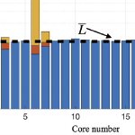
 Barrier islands are susceptible to erosion, overwash, and breaching during intense storms. However, these processes are not represented typically in large-domain models for storm surge and coastal inundation. In this study, we explore the requirements for bridging the gap between dune-scale morphodynamic and region-scale flooding models. A high-resolution XBeach model is developed to represent the morphodynamics during Hurricane Isabel (2003) in the North Carolina (NC) Outer Banks. The model domain is extended to more than 30 km of Hatteras Island and is thus larger than in previous studies. The predicted dune erosion is in good agreement with post-storm observed topography, and an ‘‘excellent’’ Skill Score of 0.59 is obtained on this large domain. Sensitivity studies show the morphodynamic model accuracy is decreased as the mesh spacing is coarsened in the cross-shore direction, but the results are less sensitive to the alongshore resolution. A new metric to assess model skill, Water Overpassing Area (WOA), is introduced to account for the available flow pathway over the dune crest. Together, these findings allow for upscaled parameterizations of erosion in larger-domain models. The updated topography, obtained from XBeach prediction, is applied in a region-scale flooding model, thus allowing for enhanced flooding predictions in communities along the Outer Banks. It is found that, even using a fixed topography in region-scale model, the flooding predictions are improved significantly when post-storm topography from XBeach is implemented. These findings can be generalized to similar barrier island systems, which are common along the U.S. Gulf and Atlantic coasts.
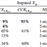 Missing building attributes are problematic for development of data-based fragility models. Relative to other disciplines, the application of imputation techniques is limited in the field of engineering. Current imputation techniques to replace missing building attributes lack evaluations of imputation model performance, which ensure accuracy and validity of the imputed data. This paper presents two imputation approaches, along with imputation diagnostic and comparison approaches, for binary building attribute data with missing observations. Predictive mean matching (PMM) and multiple imputation (MI) are used to impute foundation type and number of stories attributes. The diagnostic approach, based on the logistic regression goodness-of-fit test, is used to evaluate the imputation model fit. The comparison approach, based on the percentage of correctly imputed observations, is used to evaluate the imputation model performance. A data set of single-family homes damaged by the 2005 Hurricane Katrina is used to demonstrate implementation of the methodology. Based on the comparison approach, PMM models showed 9% and 2% greater accuracy than MI models in imputing foundation type and number of stories, respectively.