This project will address methods to adapt beach and dune nourishment to improve resilience in a changing climate. As storms become more powerful and seas continue to rise, major erosion events will occur more frequently. However, coastal communities do not yet understand how to evaluate their increasing vulnerabilities and adapt their long-term planning. In this project, we will identify the climate patterns that most often trigger the need to nourish, the variability of the time interval between such nourishments, and the economic costs and sediment volumes necessary to maintain this coastal protection policy into the 21st century.
A stochastic climate emulator will first be developed to simulate 1000s of realizations of chronological climate patterns (forced by satellite and GCM products) to create future storm events coupled with sea level rise scenarios. A library of high fidelity, open source, hydrodynamic and morphodynamic simulations (ADCIRC+SWAN and XBeach) will then be used to develop a surrogate model to predict erosion and flooding for each future realization. Triggers like beach width, dune height, and community preferences will be used to identify how often communities will need to re-nourish, contingent on future climate and sea level rise scenario.
JC Dietrich, DL Anderson. “Sustainability of Barrier Island Protection Policies under Changing Climates.” U.S. Coastal Research Program, 2019 Academic Research Opportunities, 2019/10/18 to 2021/10/17, $226,624 (Dietrich: $226,624).


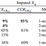 Missing building attributes are problematic for development of data-based fragility models. Relative to other disciplines, the application of imputation techniques is limited in the field of engineering. Current imputation techniques to replace missing building attributes lack evaluations of imputation model performance, which ensure accuracy and validity of the imputed data. This paper presents two imputation approaches, along with imputation diagnostic and comparison approaches, for binary building attribute data with missing observations. Predictive mean matching (PMM) and multiple imputation (MI) are used to impute foundation type and number of stories attributes. The diagnostic approach, based on the logistic regression goodness-of-fit test, is used to evaluate the imputation model fit. The comparison approach, based on the percentage of correctly imputed observations, is used to evaluate the imputation model performance. A data set of single-family homes damaged by the 2005 Hurricane Katrina is used to demonstrate implementation of the methodology. Based on the comparison approach, PMM models showed 9% and 2% greater accuracy than MI models in imputing foundation type and number of stories, respectively.
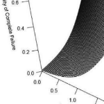 Multi-hazard hurricane data-based fragility models are able to represent multiple predictor variables, be validated based on observed data, and consider variability in building characteristics and hazard variables. This paper develops predictive hurricane, multi-hazard, single-family building fragility models for ordered categorical damage states (DS) and binary complete failure/non-complete failure using proportional odds cumulative logit and logistic regression models, respectively. In addition to their simplicity, these models are able to represent multiple hurricane hazard variables and include variable interactions, thus improving model fitting and damage prediction. Surveys of physical damage in coastal Mississippi following Hurricane Katrina (2005) and high-resolution numerical hindcast hazard intensities from the Simulating WAves Nearshore and ADvanced CIRCulation (SWAN + ADCIRC) models are used as model input. Prediction accuracy is expressed in terms of cross-validation (CV) and evaluated using leave-one-out cross-validation (LOOCV).
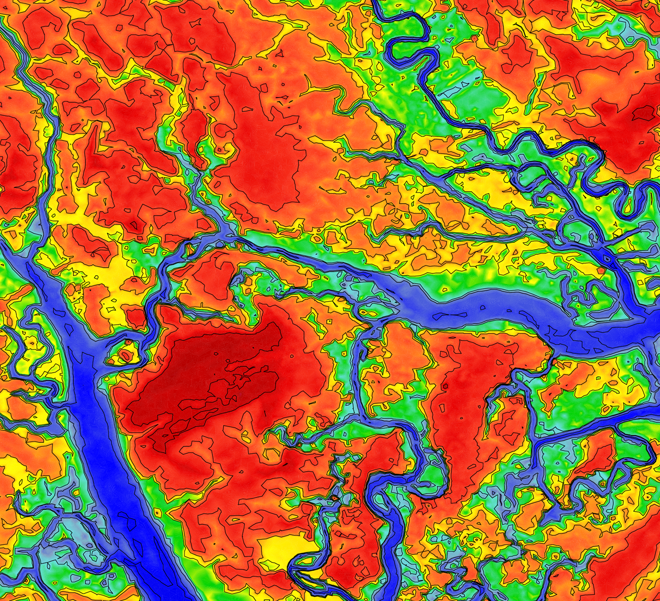
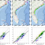 The amount and extent of coastal flooding caused by hurricanes can be sensitive to the timing or speed of the storm. For storms moving parallel to the coast, the hazards can be stretched over a larger area. Hurricane Matthew was a powerful storm that impacted the southeastern U.S. during October 2016, moving mostly parallel to the coastline from Florida through North Carolina. In this study, three sources for atmospheric forcing are considered for a simulation of Matthew’s water levels, which are validated against extensive observations, and then the storm’s effects are explored on this long coastline. It is hypothesized that the spatial variability of Matthew’s effects on total water levels is partly due to the surge interacting nonlinearly with tides. By changing the time of occurrence of the storm, differences in storm surge are observed in different regions due to the storm coinciding with other periods in the tidal cycles. These differences are found to be as large as 1m and comparable to the tidal amplitude. A change in forward speed of the storm also should alter its associated flooding due to differences in the duration over which the storm impacts the coastal waters. With respect to the forward speed, the present study contributes to established results by considering the scenario of a shore-parallel hurricane. A faster storm caused an increase in peak water levels along the coast but a decrease in the overall volume of inundation. On the other hand, a slower storm pushed more water into the estuaries and bays and flooded a larger section of the coast. Implications for short-term forecasting and long-term design studies for storms moving parallel to long coastlines are discussed herein.