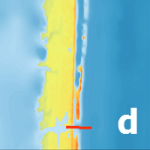
One of the most unpredictable and deadly parts of a coastal storm is the storm surge, which can cause devastating flooding of coastal regions, and can result in loss of property and life. Storm surge is a result of winds pushing water from the nearshore ocean to rise above regular tide levels. Storm surge can have a short duration; elevated water levels are limited to when the storm winds are strongest at the coast, typically for a few hours as the storm makes landfall. This short duration is a challenge for predictions of when storm surge will start, how long it will persist, and which regions will be flooded.
To predict storm surge and its associated flooding in coastal areas, numerical models must have a detailed representation of the impacted region, and thus be accurate, without having too much detail, which can limit efficiency. This research examines the use of a multi-resolution approach to improve both efficiency and accuracy. The key idea is that, as a storm travels across the ocean, it will affect different regions at different times. Early on, as the storm moves in open water and far from people, efficiency is more important in the model predictions. But as the storm moves toward the coast, it becomes necessary to have a higher accuracy near coastal communities and infrastructure. This research examines the use of multi-resolution simulations in which, as a storm travels along its track, the model ‘switches’ from lower resolution in open water to higher resolution as the storm moves closer to land. The main research question is to determine when is it most beneficial to switch resolutions by determining when storm effects are first seen at the coast.
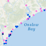
 This research will explore the arrival of storm effects for Florence, which made landfall along the North Carolina coast during September 2018. It is an ideal storm for this research as its track was shore-normal, and thus its coastal effects increased as it approached landfall. This will allow for investigating the most optimal switch by focusing on a single switch between a lower-resolution mesh to a higher-resolution mesh. The switches will be initiated by several triggers, including wind speeds and water levels at the coast and inland locations, and with several lead times, including near and several days before landfall. Model performance will be quantified via comparisons to observations of storm effects in the region, as well as to a single, high-resolution simulation for the full storm. It will be shown that switching from a coarse resolution mesh to a fine resolution mesh will lead to an increase in efficiency gains across all switching simulations with the most optimal switch time resulting in the most accurate predictions of water levels as compared to our full high-resolution simulation.
The results of this research will provide valuable contributions to forecasters working tirelessly during hurricane season to produce accurate and efficient predictions of coastal flooding impacts. With this information, real-time forecasts can be delivered sooner to emergency managers for informing evacuation zones, thus saving lives.
AC Poisson (2021). “Identifying the Earliest Signs of Storm Impacts to Improve Hurricane Flooding Forecasts,” North Carolina State University.


 Coastal flooding models are used to predict the timing and magnitude of inundation during storms, both for real-time forecasting and long-term design. However, there is a need for faster flooding predictions that also represent flow pathways and barriers at the scales of critical infrastructure. This need can be addressed via subgrid corrections, which use information at smaller scales to ‘correct’ the flow variables (water levels, current velocities) averaged over the mesh scale. Recent studies have shown a decrease in run time by 1 to 2 orders of magnitude, with the ability to decrease further if the model time step is also increased. In this study, subgrid corrections are added to a widely used, finite-element-based, shallow water model to better understand how they can improve the accuracy and efficiency of inundation predictions. The performance of the model, with and without subgrid corrections, is evaluated on scenarios of tidal flooding in a synthetic domain and a small bay in Massachusetts, as well as a scenario with a real atmospheric forcing and storm surge in southwest Louisiana. In these tests we observed that the subgrid corrections can increase model speed by 10 to 50 times, while still representing flow through channels below the mesh scale to inland locations.
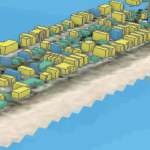 Hurricanes are devastating natural hazards that often cause damage to the built environment as a result of their loadings, which include storm surge, waves, and wind, often in combination. Modeling these hazards individually and their effects on buildings is a complex process because each loading component within the hazard behaves differently, affecting either the building envelope, the structural system, or the interior contents. Realistic modeling of hurricane effects requires a multihazard approach that considers the combined effects of wind, surge, and waves. Previous studies focused primarily on modeling these hazards individually, with less focus on the multihazard impact on the whole building system made up of the combination of the structure and its interior contents. The analysis resolution used in previous studies did not fully enable hurricane risk assessment through a detailed investigation of the vulnerability at the component-level or subassembly-level (a group of components such as interior contents, structural components, or nonstructural components). To address these research gaps, a robust multihazard hurricane risk analysis model that uses high-resolution hazard, exposure, and vulnerability models was developed. This model uses a novel approach to combine the storm surge and wave fragility functions with a suite of existing wind fragilities to account for structural damage and then combines them with another suite of flood-based fragilities to account for interior content damage. The proposed vulnerability model was applied to the state of North Carolina as an example of a regional-scale assessment to demonstrate the ability of the method to predict damage at the building level across this large spatial domain. This model enables better understanding of the damages caused by hurricanes in coastal regions, thereby setting initial post-impact conditions for community resilience assessment and investigation of recovery policy alternatives.
 In this dissertation, first a morphodynamic model is used to explore the effects of Isabel (2003) on the NC Outer Banks, with the focus on a large domain that covers 30 km of the barrier island from Rodanthe to Avon. It is hypothesized that the model can be coarsened and expanded to a large domain while preserving accuracy. Model predictions for dune erosion and overwash are in good agreement with post-storm observations. Sensitivity studies show that the model accuracy is less sensitive to the alongshore resolution of the mesh. Then, the topographic elevation changes are upscaled to a region-scale flooding model to allow overwash and inundation behind the dunes. The loose coupling of these process-based models improves the flooding predictions in region-scale model significantly.
 Then, a more complex case of beaching and its impacts on larger-scale circulations are explored. Isabel (2003) breached the barrier island near the town of Hatteras and formed three channels connecting the ocean to the sound. Two-way coupling of high-resolution numerical models for coastal erosion and flooding is implemented to study the temporal and spatial evolution of the breach and its contribution to the hydrodynamics in the sound. It is hypothesized that the channels were formed due to the combined effects of ocean-side dune erosion and lagoon-side elevated water levels. The model shows that the flow from the sound to the ocean has an important role in deepening the breached channels. The morphodynamic model can predict the initiation and approximate location of the breach. However, it failed to accurately capture the channels’ depths. Several flooding scenarios are considered to implement the ground surface changes in the flooding model. The evolving breach can affect the timing and extent of flow into the lagoon. The model results show that the breach has region-scale effects on flooding that extend about 10 km into the lagoon.
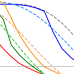 Finally, the erosion of nourished beaches subjected to multiple storms is investigated. Beach nourishment provides a buffer during extreme events in the short-termbut has a finite lifespan as the beach responds to subsequent storms. Numerical models are widely used to predict the beach morphodynamics, however, they are computationally expensive. In this research, a surrogate model is developed by coupling deterministic and probabilistic models to improve the computational efficiency and to include the randomness of possible future scenarios. A large data set of storm data and beach profiles is used to create a library of thousands of hypothetical scenarios to train the surrogate model. It is hypothesized that adding the beach profile variability in the analysis can improve the model in the sense that it can be applied to any beach state. The results show that predicted erosion volume by the surrogate model is very close to the numerical model predictions. The model produced the results in a few seconds which shows a significant improvement in computational time compared to numerical models.
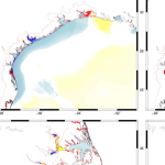 Storm surge and coastal flooding predictions can require high resolution of critical flow pathways and barriers, typically with simulations using grids/meshes with millions of cells/elements to represent a coastal region. However, the cost of this resolution can slow forecasts during a storm. To add resolution when and where it is needed, previous studies have used adaptive mesh methods, which update resolution at single or multiple cells but which require hierarchies of and thresholds for refinement, and nesting methods, which update resolution at subdomains but which require additional simulations. This research proposes a middle way, in which predictions from a coarse mesh are mapped, mid-simulation, onto a fine mesh with increased resolution near the storm’s projected landfall location. The coarse and fine meshes are pre-developed, thus removing any refinement decisions during the simulation, the solution mapping uses a widely used framework, thus enabling an efficient interpolation, and the same simulation is continued, thus eliminating a separate full-domain simulation. For four historical storms, results show efficiency gains of up to 53 percent, with minimal accuracy losses relative to a static simulation.
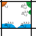 Subgrid modeling to account for unresolved topography within the context of shallow water equations relies on the use of coarse grids for computational efficiency. However, excessively coarse grids can lead to artificial cross flows between hydrologically disconnected areas separated by physical barriers smaller than the grid size. An approach based on introducing cell and edge clones, consisting of connected groups of pixels in each cell, is able to systematically remove such artificial cross flows. Such an approach considers that the subgrid barriers permanently divide flow among clones and effectively restrict flow to a predetermined path. In this work, a simple algorithm, along with the use of an overtopping formula, is proposed to extend the clone approach to a scenario in which clones are allowed to be further split and merged as needed, depending on the surface elevation during a given runtime. The algorithm is intended for accommodating the possibility of the subgrid barriers being inundated and no-longer dividing the flow during an extreme event. The performance of the proposed algorithm is demonstrated through a series of idealized and more realistic test cases, showing considerable improvements over existing methodologies.
 Hurricanes or typhoons are multi-hazard events that usually result in strong winds, storm surge, waves, and debris flow. A community-level multi-hazard hurricane risk analysis approach is proposed herein to account for the combined impacts of hazards driven by hurricanes including surge, wave, and wind. A tightly coupled ADCIRC and SWAN model is used to account for the surge and wave hazard. Community-level exposure analysis is conducted using a portfolio of building archetypes associated with each hazard. A building-level hurricane vulnerability model is developed using fragility functions to account for content, building envelope, and structural damage. These fragility functions calculate the exceedance probability of predefined damage states associated with each hazard. Then, a building damage state is calculated based on the maximum probability of being in each damage state corresponding to each hazard. The proposed hurricane risk model is then applied to Waveland, Mississippi, a community that was severely impacted by Hurricane Katrina in 2005. The main contribution of this research is modeling the community-level hurricane vulnerability in terms of damage to the building envelope and interior contents driven by surge, wave, and wind using fragility functions to provide a comprehensive model for resilience-informed decision-making.
 As coastal circulation models have evolved to predict storm-induced flooding, they must include progressively more overland regions that are normally dry, to where now it is possible for more than half of the domain to be needed in none or only some of the computations. While this evolution has improved real-time forecasting and long-term mitigation of coastal flooding, it poses a problem for parallelization in an HPC environment, especially for static paradigms in which the workload is balanced only at the start of the simulation. In this study, a dynamic rebalancing of computational work is developed for a finite-element-based, shallow-water, ocean circulation model of extensive overland flooding. The implementation has a low overhead cost, and we demonstrate a realistic hurricane-forced coastal flooding simulation can achieve peak speed-ups near 45% over the static case, thus operating now at 80−90% efficiency.