

 One of the most unpredictable and deadly parts of a coastal storm is the storm surge, which can cause devastating flooding of coastal regions, and can result in loss of property and life. Storm surge is a result of winds pushing water from the nearshore ocean to rise above regular tide levels. Storm surge can have a short duration; elevated water levels are limited to when the storm winds are strongest at the coast, typically for a few hours as the storm makes landfall. This short duration is a challenge for predictions of when storm surge will start, how long it will persist, and which regions will be flooded.
To predict storm surge and its associated flooding in coastal areas, numerical models must have a detailed representation of the impacted region, and thus be accurate, without having too much detail, which can limit efficiency. This research examines the use of a multi-resolution approach to improve both efficiency and accuracy. The key idea is that, as a storm travels across the ocean, it will affect different regions at different times. Early on, as the storm moves in open water and far from people, efficiency is more important in the model predictions. But as the storm moves toward the coast, it becomes necessary to have a higher accuracy near coastal communities and infrastructure. This research examines the use of multi-resolution simulations in which, as a storm travels along its track, the model ‘switches’ from lower resolution in open water to higher resolution as the storm moves closer to land. The main research question is to determine when is it most beneficial to switch resolutions by determining when storm effects are first seen at the coast.
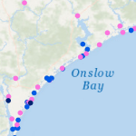
 This research will explore the arrival of storm effects for Florence, which made landfall along the North Carolina coast during September 2018. It is an ideal storm for this research as its track was shore-normal, and thus its coastal effects increased as it approached landfall. This will allow for investigating the most optimal switch by focusing on a single switch between a lower-resolution mesh to a higher-resolution mesh. The switches will be initiated by several triggers, including wind speeds and water levels at the coast and inland locations, and with several lead times, including near and several days before landfall. Model performance will be quantified via comparisons to observations of storm effects in the region, as well as to a single, high-resolution simulation for the full storm. It will be shown that switching from a coarse resolution mesh to a fine resolution mesh will lead to an increase in efficiency gains across all switching simulations with the most optimal switch time resulting in the most accurate predictions of water levels as compared to our full high-resolution simulation.
The results of this research will provide valuable contributions to forecasters working tirelessly during hurricane season to produce accurate and efficient predictions of coastal flooding impacts. With this information, real-time forecasts can be delivered sooner to emergency managers for informing evacuation zones, thus saving lives.

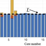 As coastal circulation models have evolved to predict storm-induced flooding, they must include progressively more overland regions that are normally dry, to where now it is possible for more than half of the domain to be needed in none or only some of the computations. While this evolution has improved real-time forecasting and long-term mitigation of coastal flooding, it poses a problem for parallelization in an HPC environment, especially for static paradigms in which the workload is balanced only at the start of the simulation. In this study, a dynamic rebalancing of computational work is developed for a finite-element-based, shallow-water, ocean circulation model of extensive overland flooding. The implementation has a low overhead cost, and we demonstrate a realistic hurricane-forced coastal flooding simulation can achieve peak speed-ups near 45% over the static case, thus operating now at 80−90% efficiency.
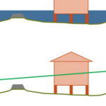 During coastal storms, forecasters and researchers use numerical models to predict the magnitude and extent of coastal flooding. These models must represent the large regions that may be affected by a storm, and thus, they can be computationally costly and may not use the highest geospatial resolution. However, predicted flood extents can be downscaled (by increasing resolution) as a post-processing step. Existing downscaling methods use either a static extrapolation of the flooding as a flat surface, or rely on subsequent simulations with nested, full-physics models at higher resolution. This research explores a middle way, in which the downscaling includes simplified physics to improve accuracy. Using results from a state-of-the-art model, we downscale its flood predictions with three methods: (1) static, in which the water surface elevations are extrapolated horizontally until they intersect the ground surface; (2) slopes, in which the gradient of the water surface is used; and (3) head loss, which accounts for energy losses due to land cover characteristics. The downscaling methods are then evaluated for forecasts and hindcasts of Hurricane Florence (2018), which caused widespread flooding in North Carolina. The static and slopes methods tend to over-estimate the flood extents. However, the head loss method generates a downscaled flooding extent that is a close match to the predictions from a higher-resolution, full-physics model. These results are encouraging for the use of these downscaling methods to support decision-making during coastal storms.
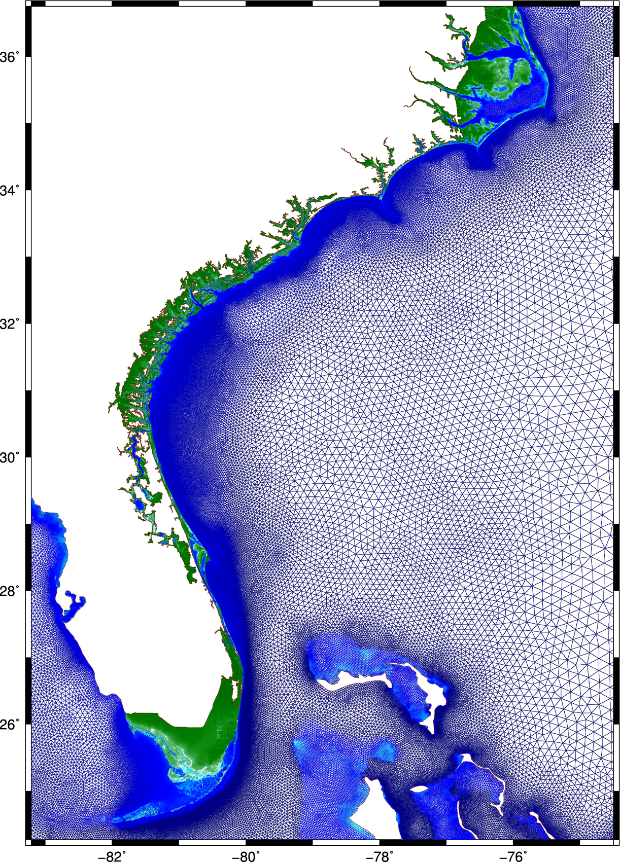 This research describes a method to improve the accuracy and efficiency of coastal flooding predictions. First, an existing model is used to explore the effect of storm forward speed and timing on tides and storm surge during Hurricane Matthew (2016). It is hypothesized that the spatial variability of Matthew’s effects on total water levels is due to the surge interacting nonlinearly with tides. If the storm occurred a few hours earlier or later, then the largest surges would have been shifted to other regions of the U.S. southeast coast. A change in forward speed of the storm also should alter its associated flooding due to differences in the duration over which the storm impacts the coastal waters. If the storm had moved faster, then the peak water levels would have increased along the coast, but the overall volume of inundation would have decreased. Then this research explores ways to increase the model’s accuracy and efficiency. To better represent Matthew’s effects, a mesh with detailed coverage of the coastal regions from Florida to North Carolina was developed by combining regional meshes originally developed for floodplain mapping. Compared to predictions using the earlier model, the new mesh allows for simulations of inundation that better match to observations especially inland.
 Then, to best utilize this new mesh, a multi-resolution approach is implemented to use meshes of varying resolution when and where it is required. It is hypothesized that by `switching’ from coarse- to fine-resolution meshes, with the resolution in the fine mesh concentrated only at specific coastal regions influenced by the storm at that point in time, both accuracy and computational gains can be achieved. As the storm approaches the coastline and the landfall location becomes more certain, the simulation will switch to a fine-resolution mesh that describes the coastal features in that region. Application of the approach during Hurricanes Matthew and Florence revealed the predictions to improve in both accuracy and efficiency, as compared to that from single simulations on coarse- and fine-resolution meshes, respectively.