Coastal areas are subjected to storms and subsequent erosion and flooding. Waves and storm surge can cause damage to infrastructure and short- and long-term changes to coastal morphology. These morphodynamic changes can range from mild beach erosion to severe dune removal, overwash, and breaching. In this dissertation, a combination of models are used to explore the storm-driven hydro- and morphodynamic processes on different scales and their interactions over time. Additionally, their application is extended for prediction of beach response to sea-storms by coupling deterministic and probabilistic models.
 In this dissertation, first a morphodynamic model is used to explore the effects of Isabel (2003) on the NC Outer Banks, with the focus on a large domain that covers 30 km of the barrier island from Rodanthe to Avon. It is hypothesized that the model can be coarsened and expanded to a large domain while preserving accuracy. Model predictions for dune erosion and overwash are in good agreement with post-storm observations. Sensitivity studies show that the model accuracy is less sensitive to the alongshore resolution of the mesh. Then, the topographic elevation changes are upscaled to a region-scale flooding model to allow overwash and inundation behind the dunes. The loose coupling of these process-based models improves the flooding predictions in region-scale model significantly.
 Then, a more complex case of beaching and its impacts on larger-scale circulations are explored. Isabel (2003) breached the barrier island near the town of Hatteras and formed three channels connecting the ocean to the sound. Two-way coupling of high-resolution numerical models for coastal erosion and flooding is implemented to study the temporal and spatial evolution of the breach and its contribution to the hydrodynamics in the sound. It is hypothesized that the channels were formed due to the combined effects of ocean-side dune erosion and lagoon-side elevated water levels. The model shows that the flow from the sound to the ocean has an important role in deepening the breached channels. The morphodynamic model can predict the initiation and approximate location of the breach. However, it failed to accurately capture the channels’ depths. Several flooding scenarios are considered to implement the ground surface changes in the flooding model. The evolving breach can affect the timing and extent of flow into the lagoon. The model results show that the breach has region-scale effects on flooding that extend about 10 km into the lagoon.
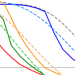 Finally, the erosion of nourished beaches subjected to multiple storms is investigated. Beach nourishment provides a buffer during extreme events in the short-termbut has a finite lifespan as the beach responds to subsequent storms. Numerical models are widely used to predict the beach morphodynamics, however, they are computationally expensive. In this research, a surrogate model is developed by coupling deterministic and probabilistic models to improve the computational efficiency and to include the randomness of possible future scenarios. A large data set of storm data and beach profiles is used to create a library of thousands of hypothetical scenarios to train the surrogate model. It is hypothesized that adding the beach profile variability in the analysis can improve the model in the sense that it can be applied to any beach state. The results show that predicted erosion volume by the surrogate model is very close to the numerical model predictions. The model produced the results in a few seconds which shows a significant improvement in computational time compared to numerical models.
This research has the potential to improve the prediction of storm-driven erosion, overwash, inundation and breaching. The loose coupling of hydro- and morphodynamic models allows for better predictions of storm-driven flooding into previously protected areas, such as coastal communities and back-barrier regions. The use of observed beach profiles in the development of a surrogate model can improve its predictions of nourishment response to single and successive storms. These better predictions can enable better planning and design for mitigation of future hazards.
A Gharagozlou (2021). “Coupling of Deterministic and Probabilistic Models for Prediction of Storm-Driven Erosion on Barrier Islands,” North Carolina State University.


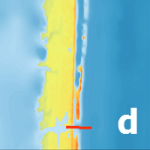
 Barrier islands are a primary coastal defense and often experience erosion during storms. When they fail due to storm-induced breaching, there can be significant changes to the small- and large-scale hydrodynamics and morphodynamics of the region. In this study, we explore the formation of a breach on Hatteras Island, North Carolina, during Isabel (2003) and the subsequent flooding into Pamlico Sound. Two-way coupling of high-fidelity, high-resolution numerical models for coastal erosion and flooding enables a better understanding of the formation of the breach, as well as scenarios of the breach’s effects on the circulation in the region. The breach connecting the ocean to the sound formed during the day of landfall. It is shown that, during the storm, overwash and inundation from the ocean led to deterioration of the beach and dunes, and then after the storm, the creation of channels through the island was sensitive to elevated water levels in the lagoon. Then flooding scenarios are considered in which the ground surface of the hydrodynamic model was (a) static, updated with the (b) pre- and post-storm observations, and updated dynamically with (c) erosion model predictions and (d) erosion model predictions with elevated lagoon-side water levels. The model results show that the breach has region-scale effects on flooding that extend 10 to 13 km into the lagoon, increasing the local water levels by as much as 1.5 m. These results have implications for similar island-lagoon systems threatened by storms.
 Coastal flooding models are used to predict the timing and magnitude of inundation during storms, both for real-time forecasting and long-term design. However, there is a need for faster flooding predictions that also represent flow pathways and barriers at the scales of critical infrastructure. This need can be addressed via subgrid corrections, which use information at smaller scales to ‘correct’ the flow variables (water levels, current velocities) averaged over the mesh scale. Recent studies have shown a decrease in run time by 1 to 2 orders of magnitude, with the ability to decrease further if the model time step is also increased. In this study, subgrid corrections are added to a widely used, finite-element-based, shallow water model to better understand how they can improve the accuracy and efficiency of inundation predictions. The performance of the model, with and without subgrid corrections, is evaluated on scenarios of tidal flooding in a synthetic domain and a small bay in Massachusetts, as well as a scenario with a real atmospheric forcing and storm surge in southwest Louisiana. In these tests we observed that the subgrid corrections can increase model speed by 10 to 50 times, while still representing flow through channels below the mesh scale to inland locations.
 Hurricanes are devastating natural hazards that often cause damage to the built environment as a result of their loadings, which include storm surge, waves, and wind, often in combination. Modeling these hazards individually and their effects on buildings is a complex process because each loading component within the hazard behaves differently, affecting either the building envelope, the structural system, or the interior contents. Realistic modeling of hurricane effects requires a multihazard approach that considers the combined effects of wind, surge, and waves. Previous studies focused primarily on modeling these hazards individually, with less focus on the multihazard impact on the whole building system made up of the combination of the structure and its interior contents. The analysis resolution used in previous studies did not fully enable hurricane risk assessment through a detailed investigation of the vulnerability at the component-level or subassembly-level (a group of components such as interior contents, structural components, or nonstructural components). To address these research gaps, a robust multihazard hurricane risk analysis model that uses high-resolution hazard, exposure, and vulnerability models was developed. This model uses a novel approach to combine the storm surge and wave fragility functions with a suite of existing wind fragilities to account for structural damage and then combines them with another suite of flood-based fragilities to account for interior content damage. The proposed vulnerability model was applied to the state of North Carolina as an example of a regional-scale assessment to demonstrate the ability of the method to predict damage at the building level across this large spatial domain. This model enables better understanding of the damages caused by hurricanes in coastal regions, thereby setting initial post-impact conditions for community resilience assessment and investigation of recovery policy alternatives.