

Category Archives: ADCIRC
Poster: Fall 2023 Conferences
JS Knowles, JC Dietrich, JT Voight. “Storm Surge Predictions at Hyperlocal Sites.” Climate Leaders Program Fall Symposium, North Carolina State University, 28 Sep 2023.
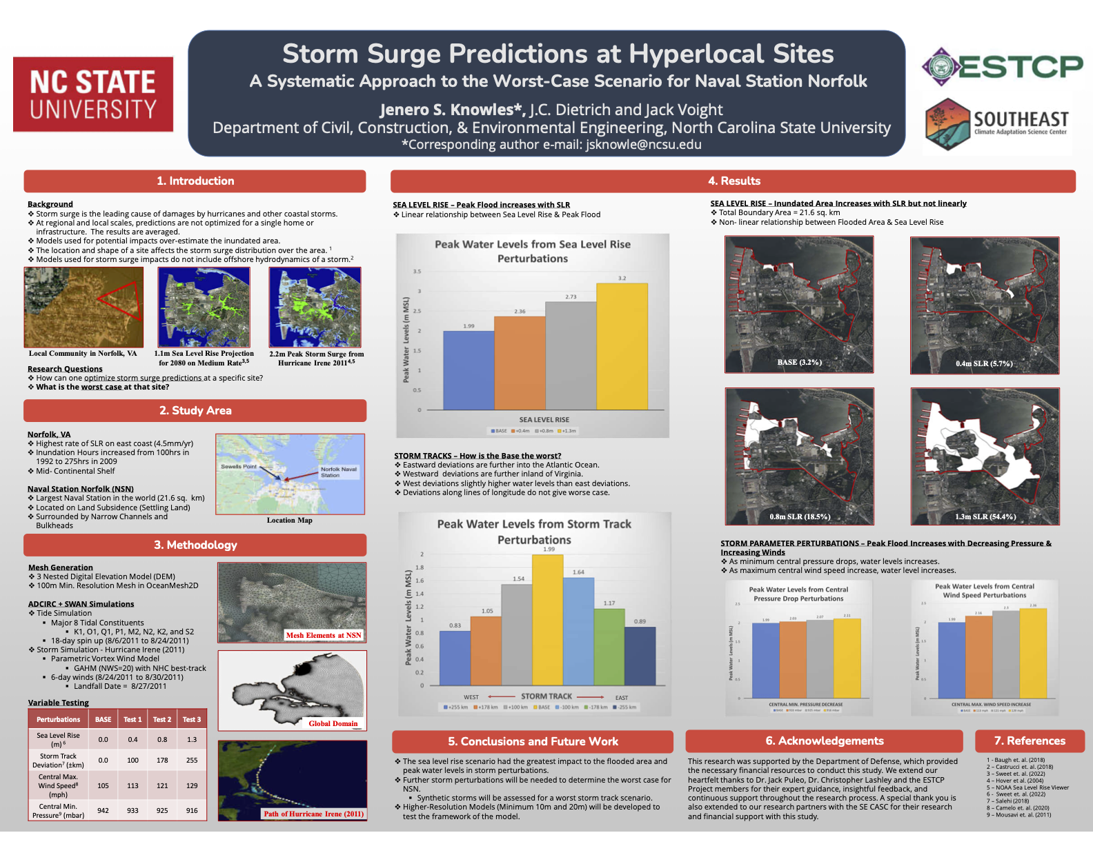
Storm Surge Predictions at Hyperlocal Sites
Efficiency Gains for Spectral Wave Models in Coupled Frameworks
We propose to modernize a spectral wave model to allow for more flexibility and efficiency within a coupled modeling framework. It is now commonplace for spectral wave models to run alongside other models for circulation and related coastal processes. These models can be coupled within sophisticated frameworks or at the source-code level. However, the widespread use of coupled models has also led to the identification of inefficiencies. Spectral wave models tend to be computationally expensive, and this cost can be amplified when they are coupled with other models. There are known methods for reducing the cost of spectral wave models, such as the nesting of nearshore and regional domains with offshore forcing from other sources, but these methods may have challenges in a coupled framework, such as the need to interpolate between nested domains. The coupling overhead can be (and has been) minimized, but there may be additional methods to further reduce costs without sacrificing predictive accuracy.
Thus, there are remaining research questions related to how to improve the performance of a spectral wave model in a coupled modeling framework. What are the tradeoffs when a spectral wave model is nested nearshore and receives boundary conditions from other sources? Over what period should the spectral wave model simulate as a storm approaches a coast? Can this research lead to guidance or best practices for coupled modeling applications? This project will focus on the Simulating WAves Nearshore (SWAN) model and SWAN+ADCIRC framework, but the project findings will be transferable to other spectral wave models and frameworks. We aim to improve the ability to nest spectral wave models in both space and time, via modernization of boundary conditions and a coupled model controller, and thus improve computational efficiency.
JC Dietrich. “Efficiency gains for spectral wave models in coupled frameworks.” Department of Defense, Broad Agency Announcement, Engineer Research and Development Center, Coastal Hydraulics Laboratory, 2023/09/22 to 2025/09/21, $191,353 (Dietrich: $191,353).
Poster: Undergraduate Research Symposium 2023
JT Voight, JS Knowles, TA Cuevas López, JC Dietrich. “How will Sea Level Rise affect the Storm Surge in Norfolk, Virginia?” Undergraduate Research Symposium, North Carolina State University, 27 July 2023.
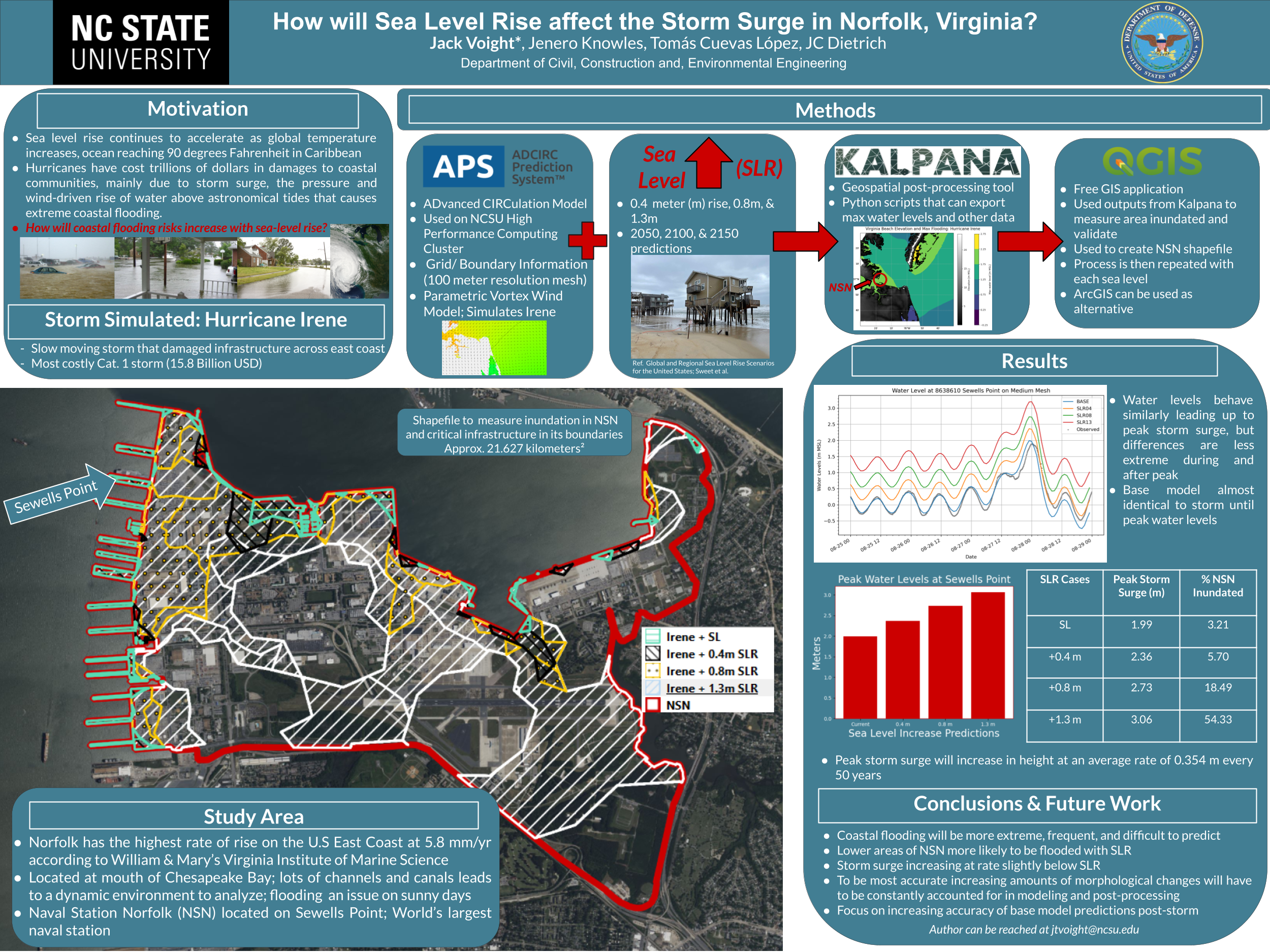
How will Sea Level Rise affect the Storm Surge in Norfolk, Virginia?
Conference: USNCCM 17
Subgrid Corrections in Storm-Driven Coastal Flooding
Coastal flooding models based on the numerical solution of the 2D shallow water equations are used widely to predict the timing and magnitude of inundation during storms, both in real-time forecasting and long-term design. Constraints on computing time, especially in forecasting, can limit the models’ spatial resolution and hence their accuracy. However, it is desirable to have fast flooding predictions that also include the best-available representation of flow pathways and barriers at the scales of critical infrastructure. This need can be addressed via subgrid corrections, which use information at smaller scales to ‘correct’ the flow variables (water levels and current velocities) averaged over the model scale.
 In this dissertation, subgrid corrections have been added to the ADvanced CIRCulation (ADCIRC) model, a widely used, continuous-Galerkin finite-element based, shallow water flow model. This includes the full derivation of averaged governing equations, closure approximations, and subgrid implementation into the source code. Testing of this new model was first performed on 3 domains: an idealized winding channel, a tidally influenced bay in Massachusetts, and a regional storm surge model covering Calcasieu Lake in Southwestern Louisiana with forcing from Rita (2005). By pre-computing the averaged variables from high-resolution bathy/topo data sets, the model can represent hydraulic connectivity at smaller scales. This allows for a coarsening of the model and thus faster predictions of flooding, while also improving accuracy. The implementation permits changing a logic-based wetting and drying algorithm to a more desirable logic-less algorithm, and requires averaging correction factors on both an elemental and vertex basis. This new framework further increases efficiency of the model, and is general enough to be used in other Galerkin-based, finite-element, hydrodynamic models. It is shown that the flooding model with subgrid corrections can match the accuracy of the conventional model, while offering a 10 to 50 times increase in speed.
 Next, higher level corrections to bottom friction and advection were incorporated into the subgrid model, and the framework was expanded and tested at the ocean-scale. It was hypothesized that by adding higher-level corrections to the model and applying them to ocean-scale domains, accurate predictions of storm surge at the smallest coastal scales can be obtained. To accomplish this, higher-level corrections were derived and implemented into the governing equations and extensive elevation and landcover data sets were curated to cover the South Atlantic Bight region of the U.S. Atlantic Coast. From there, the subgrid model was tested on an ocean-scale domain with tidal and meteorological forcing from Matthew (2016). The improvements in water level prediction accuracy due to subgrid corrections are evaluated at 218 observation locations throughout 1500 km of coast along the South Atlantic Bight. The accuracy of the subgrid model with relatively coarse spatial resolution (RMSE = 0.41 m) is better than that of a conventional model with relatively fine spatial resolution (RMSE = 0.67 m).By running on the coarsened subgrid model, we improved the accuracy over efficiency curve for the model, and as a result the computational expense of the simulation was decreased by a factor of 13.
 Finally, subgrid corrections were systematically tested on a series of five ocean-scale meshes with minimum nearshore resolutions ranging from around 60 m on the highest resolution mesh to 1000 m on the coarsest mesh. This study aimed to find the mesh resolution that offered the best trade-off between accuracy and efficiency. The limitations of the subgrid model were explored and guidelines for future users were established. In all, it was found that the primary limitation to the subgrid model came from the aliasing of important flow-blocking features such as barrier islands in the coarsest resolution meshes. However, in areas without these features subgrid corrections can offer tremendous advantages while running on very coarse meshes.
The work completed in this dissertation moves the science of subgrid corrections forward by integrating the corrections into a widely used ocean-circulation and storm surge model. This work offers improvements to both hurricane storm surge forecasting and long-term design by allowing for reduced run-times and increased accuracy on coarsened numerical meshes.
Conference: ADCIRC Users Meeting 2023
News: Department Social Media
2023/06/01 — NCSU Civil, Construction, and Environmental Engineering
YouTube
YouTube
 Jack Voight was featured on social media in a video about his summer research in our REU program. He is running simulations of storm surge and coastal flooding as part of a project about total water levels at coastal infrastructure. Glad he is part of our team!