

 Hurricane Gustav (2008) made landfall in southern Louisiana on 1 September 2008 with its eye never closer than 75 km to New Orleans, but its waves and storm surge threatened to flood the city. Easterly tropical-storm-strength winds impacted the region east of the Mississippi River for 12-15 h, allowing for early surge to develop up to 3.5 m there and enter the river and the city’s navigation canals. During landfall, winds shifted from easterly to southerly, resulting in late surge development and propagation over more than 70 km of marshes on the river’s west bank, over more than 40 km of Caernarvon marsh on the east bank, and into Lake Pontchartrain to the north. Wind waves with estimated significant heights of 15 m developed in the deep Gulf of Mexico but were reduced in size once they reached the continental shelf. The barrier islands further dissipated the waves, and locally generated seas existed behind these effective breaking zones.
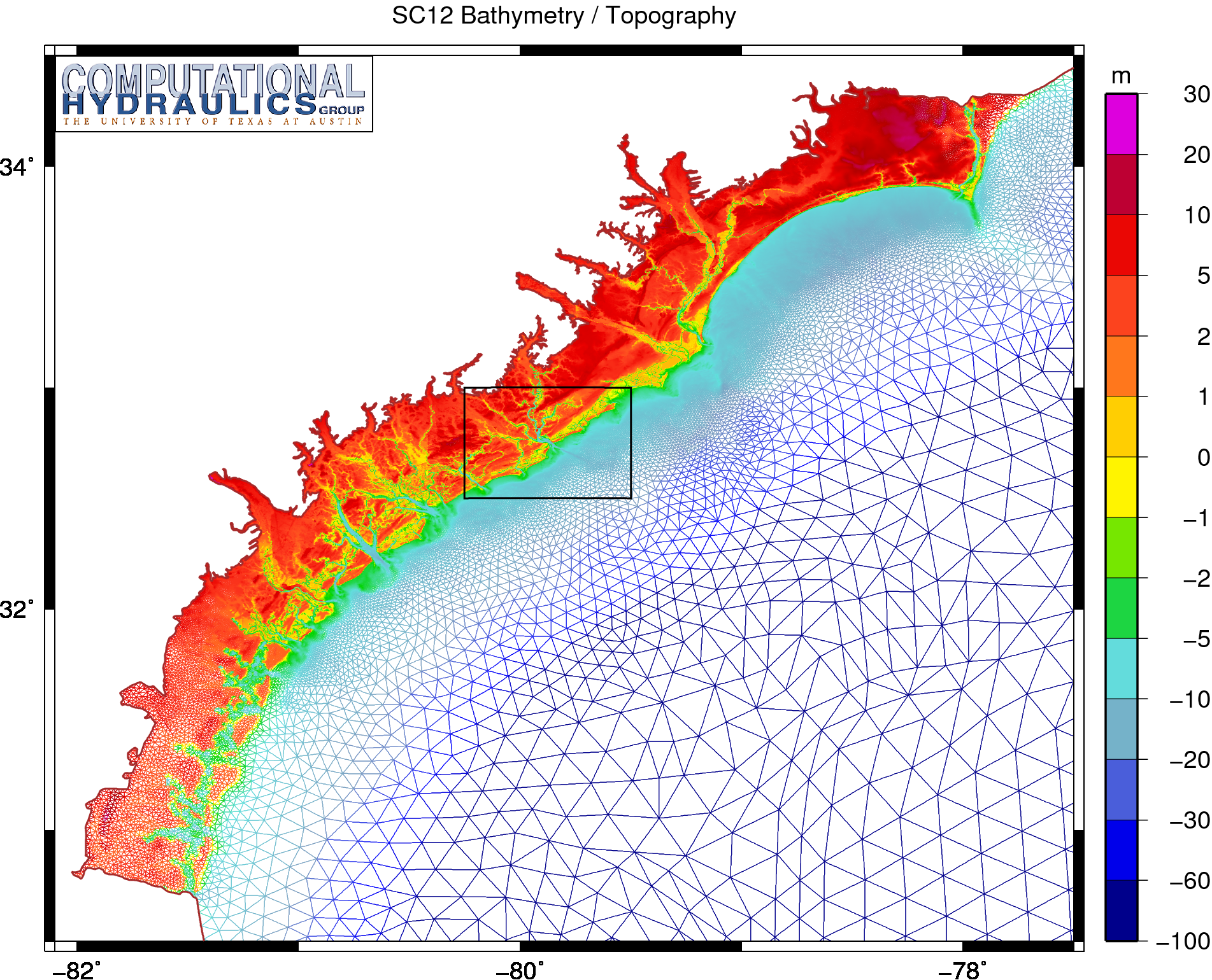
The hardening and innovative deployment of gauges since Hurricane Katrina (2005) resulted in a wealth of measured data for Gustav. A total of 39 wind wave time histories, 362 water level time histories, and 82 high water marks were available to describe the event. Computational models – including a structured-mesh deepwater wave model (WAM) and a nearshore steady-state wave (STWAVE) model, as well as an unstructured-mesh “simulating waves nearshore” (SWAN) wave model and an advanced circulation (ADCIRC) model – resolve the region with unprecedented levels of detail, with an unstructured mesh spacing of 100-200 m in the wave-breaking zones and 20-50 m in the small-scale channels. Data-assimilated winds were applied using NOAA’s Hurricane Research Division Wind Analysis System (H*Wind) and Interactive Objective Kinematic Analysis (IOKA) procedures. Wave and surge computations from these models are validated comprehensively at the measurement locations ranging from the deep Gulf of Mexico and along the coast to the rivers and floodplains of southern Louisiana and are described and quantified within the context of the evolution of the storm.
 A large, unpredicted, water level increase appeared along a substantial section of the western Louisiana and northern Texas (LATEX) coasts 12-24 hrs in advance of the landfall of Hurricane Ike (2008), with water levels in some areas reaching 3m above mean sea level. During this time the cyclonic wind field was largely shore parallel throughout the region. A similar early water level rise was reported for both the 1900 and the 1915 Galveston Hurricanes. The Ike forerunner anomaly occurred over a much larger area and prior to the primary coastal surge which was driven by onshore directed winds to the right of the storm track. We diagnose the forerunner surge as being generated by Ekman setup on the wide and shallow LATEX shelf. The longer forerunner time scale additionally served to increase water levels significantly in narrow-entranced coastal bays. The forerunner surge generated a freely propagating continental shelf wave with greater than 1.4m peak elevation that travelled coherently along the coast to Southern Texas, and was 300km in advance of the storm track at the time of landfall. This was, at some locations, the largest water level increase seen throughout the storm, and appears to be the largest freely-propagating shelf wave ever reported. Ekman setup-driven forerunners will be most significant on wide, shallow shelves subject to large wind fields, and need to be considered for planning and forecasting in these cases.
 The unstructured-mesh SWAN spectral wave model and the ADCIRC shallow-water circulation model have been integrated into a tightly-coupled SWAN+ADCIRC model. The model components are applied to an identical, unstructured mesh; share parallel computing infrastructure; and run sequentially in time. Wind speeds, water levels, currents and radiation stress gradients are vertex-based, and therefore can be passed through memory or cache to each model component. Parallel simulations based on domain decomposition utilize identical sub-meshes, and the communication is highly localized. Inter-model communication is intra-core, while intra-model communication is inter-core but is local and efficient because it is solely on adjacent sub-mesh edges. The resulting integrated SWAN+ADCIRC system is highly scalable and allows for localized increases in resolution without the complexity or cost of nested meshes or global interpolation between heterogeneous meshes. Hurricane waves and storm surge are validated for Hurricanes Katrina and Rita, demonstrating the importance of inclusion of the wave-circulation interactions, and efficient performance is demonstrated to 3062 computational cores.