This project will address the problem of recurrent, shallow flooding in low-lying coastal communities. As local sea level rise (SLR), land subsidence, and heavy rainfall events increase, so does the frequency of flooding in low-lying coastal areas. The tidal cycle now takes place on higher average sea levels, resulting in “sunny-day” flooding of roadways during high tides. Sea water also infiltrates stormwater drainage systems at low tidal levels, such that ordinary rainstorms lead to flooding. While these minor floods draw less attention than catastrophic storms, their high frequency imposes a chronic stress on coastal communities and economies by disrupting critical infrastructure services. However, information on recurrent, minor floods is scarce because they are hyper-local – often affecting a city block or intersection at a time – and relatively brief in duration. Further, prediction of chronic flooding is hindered by a poor understanding of subterranean contributions, non-tidal hydrodynamic contributions, and their interactions with tides and SLR. This problem is particularly critical for (but not unique to) communities in North Carolina (NC), many of which experience chronic flooding during non-King tide events and are seeking engineered interventions for adaptation.
The proposed work integrates outreach and research activities over the two-year project period to improve our prediction and communication of chronic flood hazards to stakeholders in the Town of Carolina Beach, NC (CB), a community plagued by chronic flooding. We will couple an existing high-resolution hydrodynamic model with a stormwater management model to hindcast and test hypotheses on the drivers of chronic, and sometimes unexpected, flood events in CB. In parallel, we will deploy a real-time flood sensor network in CB to continuously measure the stormwater network capacity and fill data gaps on the incidence and causes of chronic flooding. In response to the expressed need from local officials, we will also use the in-situ data to develop an early-warning system and engage community members to co-develop flood-mitigation design scenarios for future testing using the new model framework.
K Anarde, M Hino, A Gold, JC Dietrich. “Identifying the drivers of chronic coastal flooding: a community-centric approach.” National Oceanic and Oceanic Administration, North Carolina Sea Grant, 2022/02/01 to 2024/01/31, $119,411.


 Coastal communities throughout the world will be faced with policy decisions that affect their resilience to climate change, sea level rise, and associated impacts. Adaptation pathways, a holistic approach to policy development, may be an ideal framework for municipalities to consider in low-lying, dynamic environments such as barrier islands. Adaptation pathways identify hypothetical future timelines whereby communities adopt a different policy in response to new environmental conditions. This takes into account changing conditions and resulting hazards that exceed a threshold agreed upon by the community. In this paper, we focus on barrier island communities and give an overview of adaptation pathway methodologies, highlight several common policies considered to increase resilience, review how coastal scientists have thus far contributed to such methods, and discuss specific research agendas that could aid in future implementations. Although the use of adaptation pathways is still in its early stages in many coastal communities, the success of the process is dependent on contributions from both quantitative hazard research and consistent engagement with stakeholders in an iterative co-development of prioritized policy trajectories. Scientific needs include: better understanding of future hazards due to climate change and sea level rise, better predictions of time-dependent processes such as barrier island response to human alterations to natural coastal defense systems, and improved communication between physical scientists, social scientists, managers, and stakeholders.
 The Simulating WAves Nearshore (SWAN, Booij et al. 1999) model is used widely for predictions of waves in coastal regions. Like other spectral wave models, SWAN uses parameterizations to represent wave evolution due to sources (e.g. wind), sinks (e.g. whitecapping, bottom friction, depth-limited breaking), and resonance (e.g. quadruplet and triad wave-wave interactions). Each parameterization is based typically on observational data to represent the transfer of energy to, from, and between waves. It is necessary for each term to represent its physical process, but it is also necessary for the terms to be calibrated collectively to represent their combined effects on wave evolution. The calibrated wave predictions can then be coupled with models for circulation and coastal flooding, e.g. ADvanced CIRCulation (ADCIRC, Luettich et al. 1992).

 Our recent paper, “
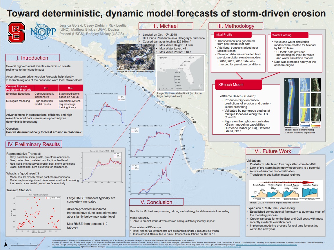
 Predictions of storm surge and flooding require models with higher resolution of coastal regions, to describe fine-scale bathymetric and topographic variations, natural and artificial channels, flow features, and barriers. However, models for real-time forecasting often use a lower resolution to improve efficiency. There is a need to understand how resolution of inland regions can translate to predictive accuracy, but previous studies have not considered differences between models that both represent conveyance into floodplains and are intended to be used in real time. In this study, the effects of model resolution and coverage are explored using comparisons between forecast-ready and production-grade models that both represent floodplains along the US southeast coast, but with typical resolutions in coastal regions of 400 and 50 m, respectively. For two storms that impacted the US southeast coast, it is shown that, although the overall error statistics are similar between simulations on the two meshes, the production-grade model allowed a greater conveyance into inland regions, which improved the tide and surge signals in small channels and increased the inundation volumes between 40% and 60%. Its extended coverage also removed water level errors of 20–40 cm associated with boundary effects in smaller regional models.