

Updated 2012/12/26: Added link to published manuscript.
Updated 2012/11/19: Changes to reflect our accepted submission to Ocean Modelling.
As we have gained experience with the coupling of SWAN and ADCIRC, we have noticed that SWAN can focus wave energy due to excessive refraction in regions with coarse mesh resolution. Wave energy can become focused unrealistically at a single mesh vertex, causing the wave properties to become non-physical. In deep water, the significant wave heights can become 150m or larger. In shallow water, the peak wave periods can become 30s or larger, as the energy is pushed into the lowest-discretized frequency bin.
We have developed a few work-around solutions to this problem (Part 1 and Part 2). These solutions have enabled the wave refraction process in the region of interest, and disabled it elsewhere in the computational domain. For example, by enabling selectively the refraction in the northern Gulf of Mexico, we can obtain the following hindcast of the significant wave heights during Hurricane Gustav (2008).
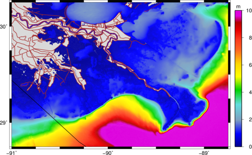
Maximum significant wave heights (m) during Gustav (2008).
However, a more robust solution would be the limiting of the spectral propagation velocities, especially the directional turning rate, based on the Courant-Friedrichs-Lewy (CFL) condition. We have implemented recently these limiters in SWAN+ADCIRC. On this page, the limiters are introduced and tested on idealized and realistic applications.
It should be noted that these limiters are not a replacement for increased mesh resolution. The SWAN solution will always be better when the mesh is improved to represent the bathymetric gradients in the region of interest. However, when it is not feasible to increase the mesh resolution, then these limiters can control the largest SWAN errors without affecting the solution elsewhere.

 Hurricane Gustav (2008) made landfall in southern Louisiana on 1 September 2008 with its eye never closer than 75 km to New Orleans, but its waves and storm surge threatened to flood the city. Easterly tropical-storm-strength winds impacted the region east of the Mississippi River for 12-15 h, allowing for early surge to develop up to 3.5 m there and enter the river and the city’s navigation canals. During landfall, winds shifted from easterly to southerly, resulting in late surge development and propagation over more than 70 km of marshes on the river’s west bank, over more than 40 km of Caernarvon marsh on the east bank, and into Lake Pontchartrain to the north. Wind waves with estimated significant heights of 15 m developed in the deep Gulf of Mexico but were reduced in size once they reached the continental shelf. The barrier islands further dissipated the waves, and locally generated seas existed behind these effective breaking zones.