

Category Archives: Kalpana
Posters: ASBPA Coastal Conference 2019
CA Rucker, N Tull, JC Dietrich, R Luettich, R Cyriac. “Improving the accuracy of a real-time ADCIRC storm surge downscaling model.” ASBPA 2019 National Coastal Conference, Myrtle Beach SC, 23 October 2019.
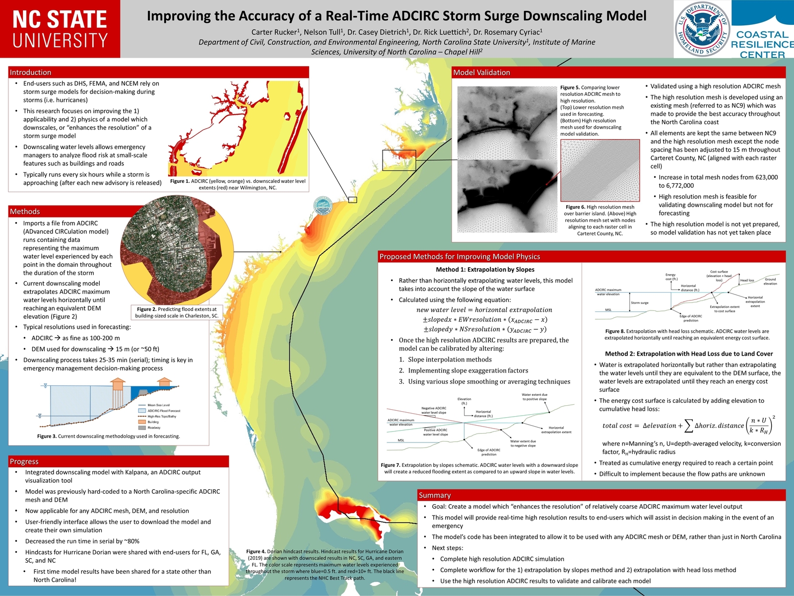
Improving the accuracy of a real-time ADCIRC storm surge downscaling model.
JL Woodruff, JC Dietrich, AB Kennedy, D Wirasaet, D Bolster, Z Silver, RL Kolar. “Improving predictions of coastal flooding via sub-mesh corrections.” ASBPA 2019 National Coastal Conference, Myrtle Beach SC, 23 October 2019.

Improving predictions of coastal flooding via sub-mesh corrections.
Presentation: ASCE NC Fall Conference
News: Modeling Florence’s Storm Surge
2019/04/26 – NCSU College of Engineering
After the Storm
After the Storm

Dr. Casey Dietrich, an assistant professor in the Department of Civil, Construction, and Environmental Engineering (CCEE), leads the Coastal and Computational Hydraulics Team and develops computational models that predict storm surge and coastal flooding. Using the model ADCIRC, the team makes predictions about how high sea waters will rise, which areas will be flooded and for how long. These predictions are made for the entire coastline, and then his team visualizes the flooding at the scales of individual buildings and coastal infrastructure. During Florence, Dietrich’s team and collaborators acted as liaisons for state emergency managers to aid their decision making.
“The models are just one data point among many, but they’re helpful in understanding hazards and used to make predictions in real time — partly to make decisions about evacuation, where to deploy resources after, safe places to put emergency vehicles and water supplies,” he said.
The state emergency managers are able to use the flooding predictions to get immediate estimates on damages, which helps communities that are figuring out how much recovery will cost.
After Hurricane Matthew in 2016, Dietrich and his colleagues improved the models’ ability to forecast encroaching water along shorelines. Post-Florence, Dietrich said the research focus is to speed up the model and allow for more permutations to see what might happen if a storm slows down or shifts direction.
Chancellor’s Visit to CCEE Department
NCSU Chancellor Randy Woodson visited the CCEE Department to learn more about our research in resilient infrastructure. The visit was organized as a poster session, with overviews of research from 10 faculty teams in related areas. Casey Dietrich presented an overview of the coastal engineering research, with help from Alejandra Ortiz and John Baugh.
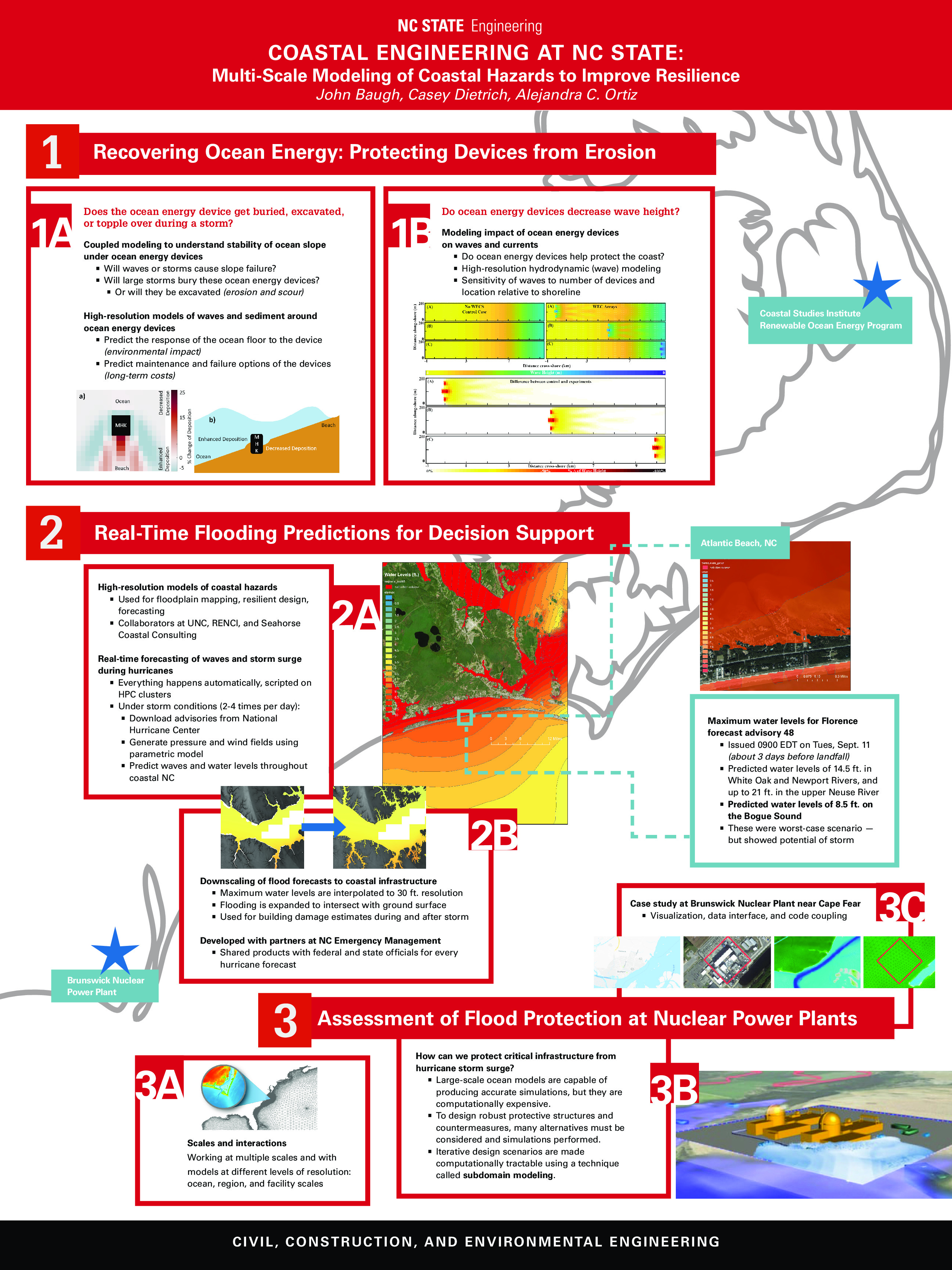
Non-comprehensive overview of coastal engineering research at NC State.
Downscaling ADCIRC Flooding Inundation Extents Using Kalpana
Updated 2020/06/24: Added documentation for --growradius none option.
Updated 2020/04/15: Added documentation for DEM vertical unit conversions.
The ADCIRC modeling system is used often to predict coastal flooding due to tropical cyclones and other storms. The model uses high resolution to represent the coastal environment, including flow pathways (inlets, man-made channels, rivers) and hydraulic controls (barrier islands, raised features). However, due to the use of large domains to represent hazards on coastlines in an entire state or multiple states, the highest resolution is typically about 20 to 50 m in coastal regions. Thus, there is a potential gap between the flooding predictions and the true flooding extents. We have developed a geospatial software to downscale the flooding extents to higher resolution.
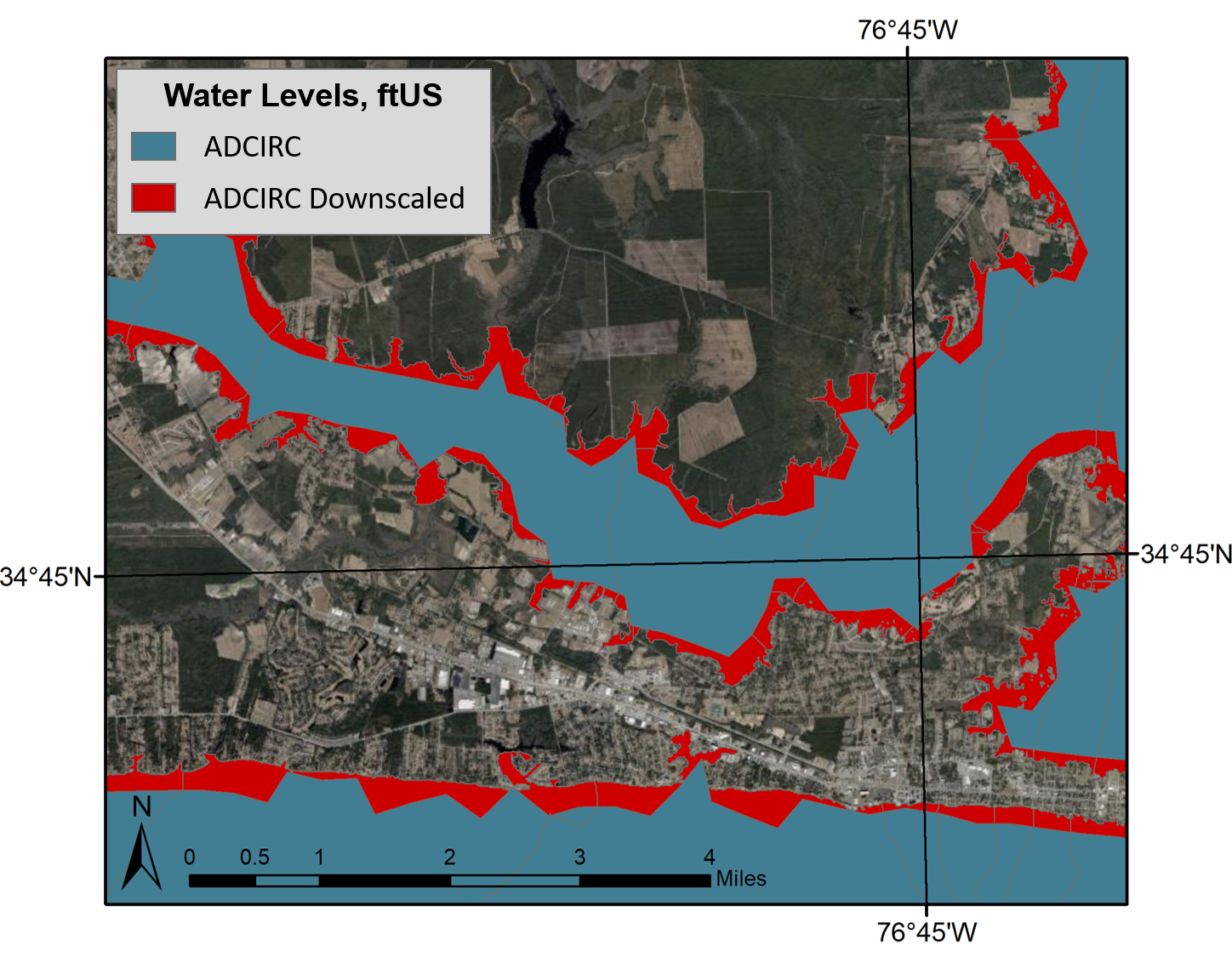
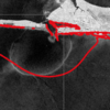
ADCIRC vs. downscaled water levels, plan view. This image shows the difference in prediction of flooding extents, with the blue portion representing the original ADCIRC flooding extents and red representing the downscaled extents.
The following documentation is for downscaling the flooding predictions by using Kalpana. This software was created originally to view ADCIRC outputs as either ESRI shapefiles or KML files (for viewing in Google Earth). ADCIRC (the ADvanced CIRCulation model) uses finite element methods to predict water levels throughout the modeled domain. Although this model is able to provide accurate predictions in a matter of minutes, these predictions have a limited resolution and are not able to provide information at the scale of buildings, roadways, and other critical infrastructure.
Wind and Plume Driven Circulation in Estuarine Systems
Mechanistic models with high spatial resolution are useful tools to represent the dynamic and non-linear feedbacks between tides, winds and freshwater inflows in the nearshore and to predict future conditions. In this thesis, several aspects of the wind-and river-plume-driven hydrodynamics and transport in estuarine systems are examined through barotropic and baroclinic models.
 The study begins with an application of a state-of-the-art storm surge model to examine the effects of meteorological forecast errors on coastal flooding predictions along the North Carolina (NC) coastline. As Hurricane Arthur (2014) moved over Pamlico Sound, it increased the total water levels to 2.5 m above sea level; this water pushed first into the river estuaries and against the inner banks, and then moved eastward to threaten the sound-side of the barrier islands. It is hypothesized that a combination of storm track and intensity errors caused errors in the forecast winds and water levels along the NC coast during Arthur. Model results reveal that, as the forecast storm track and intensity errors increase, the errors in forecast wind speeds also increase, but the errors in forecast water levels remain relatively the same, signifying the non-linear response of the coastal ocean to wind effects. By separating the forecast errors in storm track and storm strength, this study quantifies their effects on the coastal ocean, which provides useful guidance for designing relevant forecast ensembles.
 In addition to flooding impacts, storms can also cause dramatic changes in estuarine salinities, which can negatively impact estuarine ecosystems. Baroclinic models are useful tools for predicting estuarine salinity response under changing environmental conditions. In the present work, the features of wind- and plume-driven circulation in the vicinity of Choctawhatchee Bay (CB) and Destin Inlet, Florida, are analyzed with a recently-enhanced, three-dimensional, baroclinic model. Satellite imagery showed a visible brackish surface plume at Destin during low tide. The goal of the present study is to quantify variability in the plume signature due to changes in tidal and wind forcing. Modeled tides, salinities and plume signature are validated against in-situ observations and satellite imagery and then applied to analyze plume response in two scenarios. In the first case, model plume behavior is analyzed on successive days of near-constant tidal amplitudes and changing wind directions due to passing cold fronts. In the second case, plume response is investigated during consecutive days of neap-spring variability in the tides and near-constant wind speeds. Model results reveal a larger plume during spring tides and periods of weak wind forcing. Oshore winds enhance the north-south expansion of the plume, whereas onshore winds restrict the plume to the coastline.
 Finally, the validated model is applied to identify salinity and transport characteristics within CB. Based on past studies, it is hypothesized that CB is a stratified system with limited flushing and zones of distinct salinity gradients. These hypotheses are tested by analyzing bay salinities from the validated model during a period of low river flows. Model surface salinities indicate brackish conditions (20 psu) throughout the bay except for near the river mouth. Stratification (10 to 15 psu) within the bay is unaffected by the passage of cold fronts and neap-spring tidal variability. The residence time within the Choctawhatchee Bay, an important indicator of estuarine health, is computed via particle tracking and is equal to roughly 40 days.
This work advances the scientific understanding of multiple aspects of estuarine circulation including wind-driven surge and flooding, brackish plume behavior through inlets and onto the shelf, and salinity transport and stratication properties within estuaries. Research ndings lead to a better understanding of estuarine response under a wide range of atmospheric conditions, and the resulting technologies will be useful for oil spill response operations, fisheries and pollution management.
Seminar: Coffee & Viz
N Tull, JC Dietrich+, TE Langan, H Mitasova, CA Rucker, BO Blanton, JG Fleming, RA Luettich. “Enhancing Visualization of Storm Surge Guidance.” Coffee & Viz, NCSU Libraries, North Carolina State University, Raleigh, North Carolina, 19 October 2018.
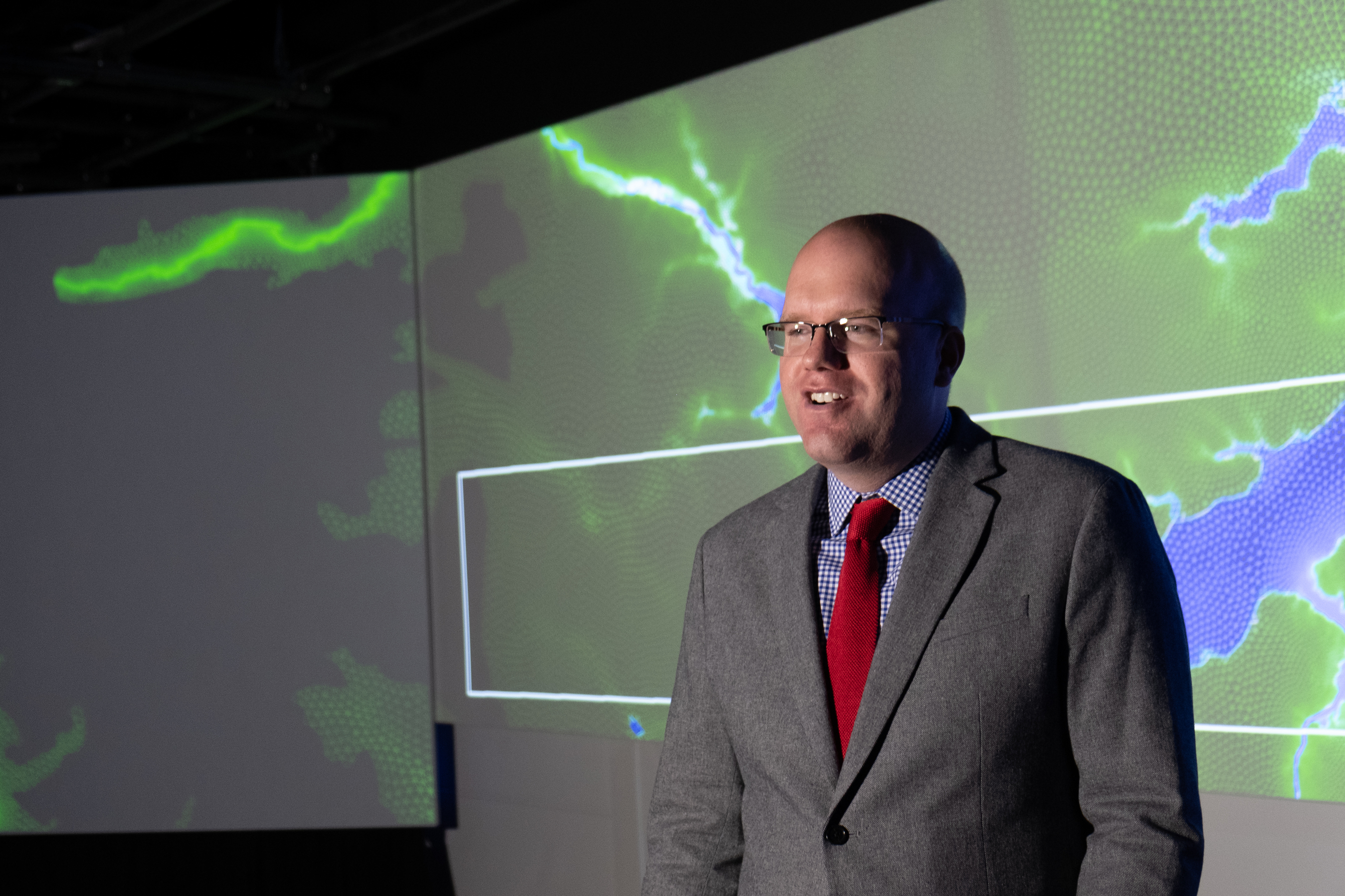
Casey Dietrich presenting at Coffee & Viz. Photo courtesy Julie Dixon.
This seminar was part of the NCSU Libraries’ Coffee & Viz event series, and it was held in the Teaching and Visualization Lab. This lab has 10 overhead projectors and can display graphics on three walls — the entire front and both full sides of the room. More photos are included below.