

 During major storm events such as hurricanes, emergency managers rely on fast and accurate forecasting models to make important decisions concerning public safety. These models can be computationally costly and cannot quickly make predictions at the highest geospatial resolution. However, model output can be post-processed to mimic high-resolution results with minimal additional computational cost. This research proposes methods for improvement in the accuracy of downscaling (enhancing the resolution of) a real-time storm surge forecasting model. Such improvements to downscaling methods include 1) expansion in its spatial applicability, 2) adding physics using water surface slopes, and 3) adding physics using friction losses across the ground surface.
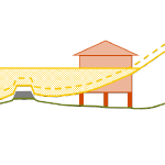
This research builds upon a process that uses maximum water elevation output from the Advanced Circulation (ADCIRC) model and downscales these results to a finer resolution by extrapolating the water levels to small-scale topography. This downscaling process is referred to as the static method. The method was originally designed for use in North Carolina (NC), where results from an ADCIRC model designed specifically for NC were downscaled to a set of NC topographical data. By joining the static method with an ADCIRC output visualization tool, the downscaling process is now able to run faster with the same level of accuracy and can run on any ADCIRC model with downscaling data from any geographical region or given resolution. This process is used to provide extra guidance to emergency managers and decision makers during hurricanes.
 The downscaling process is also improved by adding physics using the slopes method and the head loss method. The slopes method incorporates the slopes of the water levels produced by ADCIRC, rather than only the value of the water level. By interpolating ADCIRC output water elevation points into a smooth surface, slopes of this surface can be used to influence the elevations of downscaled water levels. The head loss method adds friction loss due to variations in the ground surface based on land cover types and friction associated with each type. As water travels over any surface, head loss, or a loss in energy, occurs at different rates depending on the surface roughness. This rudimentary hydrologic principle is applied to increase the accuracy of the downscaling process at minimal cost. The downscaling methods are applied for results from an ADCIRC simulation used in real-time forecasting, and then compared with results from an ADCIRC simulation with 10 times more resolution in Carteret County, NC. The static method tends to over-estimate the flood extents, and the slopes method is similar. However, the head loss method generates a downscaled flooding extent that is a close match to the predictions from the higher-resolution, full-physics model.
By improving the accuracy of downscaling methods at minimal computational cost and expanding the applicability of these downscaling methods, these methods can be used by emergency managers to provide a better estimation of flooding extents while simulating storm events.
 Multiple river-dominated estuaries line the northern Gulf coast and introduce substantial density variations. Their plumes have been shown to be highly sensitive to wind and tide effects, but in studies with limited observations and idealized wind forcing. This study explores these effects with a dynamic model that can represent the full behavior from river through estuary to shelf, and for a period with extensive observations. The inner shelf adjacent to Choctawhatchee Bay, a micro tidal estuary situated along the Florida Panhandle, is subject to buoyant, brackish outflows during the ebb-phase of the tidal cycle.
 Averaging techniques are used to generate upscaled forms of the shallow water equations for storm surge including subgrid corrections. These systems are structurally similar to the standard shallow water equations but have additional terms related to integral properties of the fine-scale bathymetry, topography, and flow. As the system only operates with coarse-scale variables (such as averaged fluid velocity) relating to flow, these fine-scale integrals require closures to relate them to the coarsened variables. Closures with different levels of complexity are identified and tested for accuracy against high resolution solutions of the standard shallow water equations. Results show that, for coarse grids in complex geometries, inclusion of subgrid closure terms greatly improves model accuracy when compared to standard solutions, and will thereby enable new classes of storm surge models.
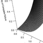 Multi-hazard hurricane data-based fragility models are able to represent multiple predictor variables, be validated based on observed data, and consider variability in building characteristics and hazard variables. This paper develops predictive hurricane, multi-hazard, single-family building fragility models for ordered categorical damage states (DS) and binary complete failure/non-complete failure using proportional odds cumulative logit and logistic regression models, respectively. In addition to their simplicity, these models are able to represent multiple hurricane hazard variables and include variable interactions, thus improving model fitting and damage prediction. Surveys of physical damage in coastal Mississippi following Hurricane Katrina (2005) and high-resolution numerical hindcast hazard intensities from the Simulating WAves Nearshore and ADvanced CIRCulation (SWAN + ADCIRC) models are used as model input. Prediction accuracy is expressed in terms of cross-validation (CV) and evaluated using leave-one-out cross-validation (LOOCV).
 The amount and extent of coastal flooding caused by hurricanes can be sensitive to the timing or speed of the storm. For storms moving parallel to the coast, the hazards can be stretched over a larger area. Hurricane Matthew was a powerful storm that impacted the southeastern U.S. during October 2016, moving mostly parallel to the coastline from Florida through North Carolina. In this study, three sources for atmospheric forcing are considered for a simulation of Matthew’s water levels, which are validated against extensive observations, and then the storm’s effects are explored on this long coastline. It is hypothesized that the spatial variability of Matthew’s effects on total water levels is partly due to the surge interacting nonlinearly with tides. By changing the time of occurrence of the storm, differences in storm surge are observed in different regions due to the storm coinciding with other periods in the tidal cycles. These differences are found to be as large as 1m and comparable to the tidal amplitude. A change in forward speed of the storm also should alter its associated flooding due to differences in the duration over which the storm impacts the coastal waters. With respect to the forward speed, the present study contributes to established results by considering the scenario of a shore-parallel hurricane. A faster storm caused an increase in peak water levels along the coast but a decrease in the overall volume of inundation. On the other hand, a slower storm pushed more water into the estuaries and bays and flooded a larger section of the coast. Implications for short-term forecasting and long-term design studies for storms moving parallel to long coastlines are discussed herein.
 In 2017, Hurricanes Harvey, Irma, and Maria caused more than $200 billion dollars of damage in the United States, as well as the incalculable cost of the loss of life and mental trauma associated with these disasters. In a changing climate, sea level rise and the potential for increasing tropical cyclone intensity can result in even more devastating damages. Therefore, engineers, community planners, and coastal residents need accurate, timely, and accessible forecasting of storm processes and their impact on coastal communities to bolster national resilience and reduce risk to life and property during these events. However, along with uncertainties in understanding and modeling of storm processes, there are complex challenges associated with determining and meeting the needs of end users who rely on these forecasts for emergency management decisions.
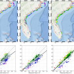
 The study begins with an application of a state-of-the-art storm surge model to examine the effects of meteorological forecast errors on coastal flooding predictions along the North Carolina (NC) coastline. As Hurricane Arthur (2014) moved over Pamlico Sound, it increased the total water levels to 2.5 m above sea level; this water pushed first into the river estuaries and against the inner banks, and then moved eastward to threaten the sound-side of the barrier islands. It is hypothesized that a combination of storm track and intensity errors caused errors in the forecast winds and water levels along the NC coast during Arthur. Model results reveal that, as the forecast storm track and intensity errors increase, the errors in forecast wind speeds also increase, but the errors in forecast water levels remain relatively the same, signifying the non-linear response of the coastal ocean to wind effects. By separating the forecast errors in storm track and storm strength, this study quantifies their effects on the coastal ocean, which provides useful guidance for designing relevant forecast ensembles.
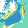
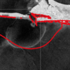 In addition to flooding impacts, storms can also cause dramatic changes in estuarine salinities, which can negatively impact estuarine ecosystems. Baroclinic models are useful tools for predicting estuarine salinity response under changing environmental conditions. In the present work, the features of wind- and plume-driven circulation in the vicinity of Choctawhatchee Bay (CB) and Destin Inlet, Florida, are analyzed with a recently-enhanced, three-dimensional, baroclinic model. Satellite imagery showed a visible brackish surface plume at Destin during low tide. The goal of the present study is to quantify variability in the plume signature due to changes in tidal and wind forcing. Modeled tides, salinities and plume signature are validated against in-situ observations and satellite imagery and then applied to analyze plume response in two scenarios. In the first case, model plume behavior is analyzed on successive days of near-constant tidal amplitudes and changing wind directions due to passing cold fronts. In the second case, plume response is investigated during consecutive days of neap-spring variability in the tides and near-constant wind speeds. Model results reveal a larger plume during spring tides and periods of weak wind forcing. Oshore winds enhance the north-south expansion of the plume, whereas onshore winds restrict the plume to the coastline.
 Finally, the validated model is applied to identify salinity and transport characteristics within CB. Based on past studies, it is hypothesized that CB is a stratified system with limited flushing and zones of distinct salinity gradients. These hypotheses are tested by analyzing bay salinities from the validated model during a period of low river flows. Model surface salinities indicate brackish conditions (20 psu) throughout the bay except for near the river mouth. Stratification (10 to 15 psu) within the bay is unaffected by the passage of cold fronts and neap-spring tidal variability. The residence time within the Choctawhatchee Bay, an important indicator of estuarine health, is computed via particle tracking and is equal to roughly 40 days.
 Storm surge prediction models rely on an accurate representation of the wind conditions. In this paper, we examine the sensitivity of surge predictions to forecast uncertainties in the track and strength of a storm (storm strength is quantified by the power dissipation of the associated wind field). This analysis is performed using Hurricane Arthur (2014), a Category 2 hurricane, which made landfall along the North Carolina (NC) coast in early July 2014. Hindcast simulations of a coupled hydrodynamic-wave model are performed on a large unstructured mesh to analyze the surge impact of Arthur along the NC coastline. The effects of Arthur are best represented by a post-storm data assimilated wind product with parametric vortex winds providing a close approximation. Surge predictions driven by forecast advisories issued by the National Hurricane Center (NHC) during Arthur are analyzed. The storm track predictions from the NHC improve over time. However, successive advisories predict an unrealistic increase in the storm’s strength. Due to these forecast errors, the global root mean square errors of the predicted wind speeds and water levels increase as the storm approaches landfall. The relative impacts of the track and strength errors on the surge predictions are assessed by replacing forecast storm parameters with the best known post-storm information about Arthur. In a “constant track” analysis, Arthur’s post storm determined track is used in place of the track predictions of the different advisories but each advisory retains its size and intensity predictions. In a “constant storm strength” analysis, forecast wind and pressure parameters are replaced by corresponding parameters extracted from the post storm analysis while each advisory retains its forecast storm track. We observe a strong correlation between the forecast errors and the wind speed predictions. However, the correlation between these errors and the forecast water levels is weak signifying a non-linear response of the shallow coastal waters to meteorological forcing.