Coastal cities are threatened by rising sea levels and stronger storms due to climate change. These hazards have motivated cities to consider adaptations via large infrastructure projects, e.g. bridges, breakwaters in Nagoya, storm surge barriers near Houston and New York City, and the emerald tutu in Boston. However, while numerous studies have predicted the benefits of these adaptations in reducing flooding, much less is known about how they may interact with ships, especially ship crashes. All of these cities are also major ports, and cargo ships continue to grow to and beyond existing infrastructure. Ship crashes have become more noticeable as “more volatile weather caused by climate change and ever-larger container ships mean the risk of losses may be rising.”
As cities (defined broadly to include the cities themselves, but also regional and national governments and agencies, e.g. USACE) consider large adaptations, they often are limited by knowledge gaps related to their technical performance. NC State and Nagoya researchers have the expertise and tools to advance knowledge and improve resilience of coastal adaptation infrastructure, but a seed grant is needed to initiate collaborations across our complementary skillsets.
JC Dietrich, T Nakamura, G Haikal, JE San Juan, Y Cho, T Tomita. “Coastal City Resilience: Infrastructure Adaptation for Ship Impact Mitigation in a Changing Climate.” NC State University, Office of Global Engagement, Nagoya University Collaborative Seed Grants, 2024/07/10, $7,000 and ¥1,000,000 (Dietrich: $2,334).
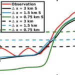 Compound flooding, the concurrence of multiple flooding mechanisms such as storm surge, heavy rainfall, and riverine flooding, poses a significant threat to coastal communities. To mitigate the impacts of compound flooding, forecasts must represent the variability of flooding drivers over a wide range of spatial scales while remaining timely. One approach to develop these forecasts is through subgrid corrections, which utilize information at smaller scales to “correct” water levels and current velocities averaged over the model scale. Recent studies have shown that subgrid models can improve both accuracy and efficiency; however, existing models are not able to account for the dynamic interactions of hydrologic and hydrodynamic drivers and their contributions to flooding along the smallest flow pathways when using a coarse resolution. Here, we have developed a solver called CoaSToRM (Coastal Subgrid Topography Research Model) with subgrid corrections to compute compound flooding in coastal systems resulting from fluvial, pluvial, tidal, and wind-driven processes. A key contribution is the model’s ability to enforce all flood drivers and use the subgrid corrections to improve the accuracy of the coarse-resolution simulation. The model is validated for Hurricane Eta 2020 in Tampa Bay, showing improved prediction accuracy with subgrid corrections at 42 locations. Subgrid models with coarse resolutions (R2 = 0.70, 0.73, 0.77 for 3-, 1.5-, 0.75-km grids) outperform standard counterparts (R2 = 0.03, 0.14, 0.26). A 3-km subgrid simulation runs roughly 50 times faster than a 0.75-km subgrid simulation, with similar accuracy.