

Tag Archives: Casey Dietrich
Wind Drag Based on Storm Sectors
The animation below shows our latest hindcast of Katrina in southeastern Louisiana. This hindcast is on our new SL16 mesh, which has 5M vertices and 10M triangular elements. This increased resolution allows us to better resolve the generation of waves in the Gulf, the dissipation of waves as they interact with the changing bathymetry and bottom friction on the continental shelf, and the fine-scale features of the circulation in the channels and marshes of the region.
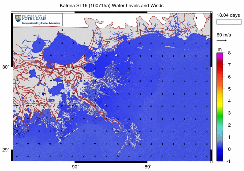
Contours of water levels (m) and vectors of wind velocities (m/s) during Katrina (2005).
While finalizing our hindcasts of the four recent, major hurricanes to impact southern Louisiana (Katrina, Rita, Gustav and Ike), we implemented a variable wind drag coefficient that depends on wind speed and also location relative to storm movement. This work follows closely the azimuthal dependence of wind drag observed by Mark Powell (2006).
Waves in Wetlands: Hurricane Gustav
 Few wave measurements have been made in wetlands during high-energy, surge events, such as hurricanes. During Hurricane Gustav in 2008, many nearshore wave measurements were made in Southeastern Louisiana. These data are used to verify a nearshore wave modeling system and to explore the characteristics of hurricane waves in wetlands. The modeling system consists of the wave generation model WAM, the nearhsore wave model STWAVE, and the circulation model ADCIRC. The measurements confirm reasonable success in modeling the waves. The measurements and modeling also expose some of the problems of measuring waves in highly-variable water depths under hurricane forcing and modeling waves in rapidly degrading wetlands.
Swell Propagation on Fine Meshes
We encountered recently a problem that may be of interest to other SWAN+ADCIRC users. As we were validating our hindcast of Hurricane Ike, we noticed that the swell propagated slower as we increased the resolution in our meshes. This behavior was caused by the SWAN convergence criteria we had selected; we were not allowing the SWAN solution to converge sufficiently. By selecting criteria that are closer to the default settings recommended in the SWAN User Manual, we were able to fix our problem.
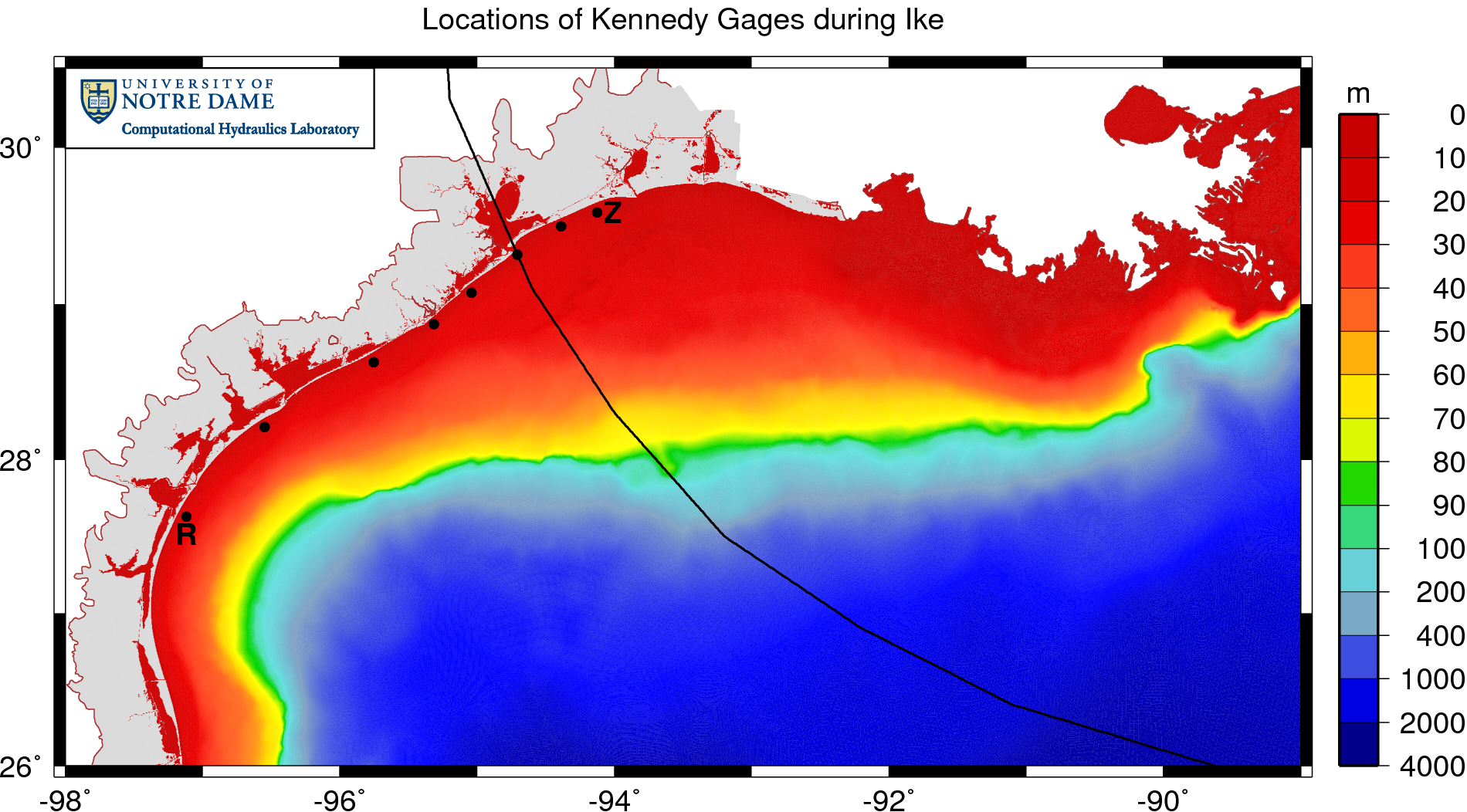
We first noticed the problem while validating the computed SWAN significant wave heights against the measured results at eight gauges deployed by Notre Dame assistant professor Andrew Kennedy. These gauges were deployed in the days before Ike’s landfall along the Texas coastline, as shown below:
Locations of Kennedy gauges during Ike (2008).
Ike’s track is shown with a black line; note how the storm curved northwestward in the Gulf of Mexico and made landfall near Galveston and Houston. The eight gauges are shown with black dots, and are located very near the coastline in 10-20m of water depth. The information measured by these gauges is extremely valuable, especially with respect to wave validation, because the gauges are located nearshore, where the waves would feel the effects of bottom friction and depth-induced breaking.
Conference: ADCIRC 2010
Seminar: University of Notre Dame
Integral Coupling of Bottom Friction
Updated 2010/06/16: Revised figures from our Gustav MWR paper.
Updated 2011/08/26: Removed the Google Maps inset.
Updated 2012/09/10: Added the Google Maps inset and updated the equations in LaTeX.
Updated 2011/08/26: Removed the Google Maps inset.
Updated 2012/09/10: Added the Google Maps inset and updated the equations in LaTeX.
One strength of the integral coupling of SWAN+ADCIRC is the increased accuracy resulting from the communication of the model components during the simulation. The computed wave solution is better because it includes the water levels and currents passed from ADCIRC, and the computed circulation solution is better because it includes the wave radiation stress gradients passed from SWAN. These benefits are described in a manuscript we submitted recently to Coastal Engineering (Dietrich et al., 2011).
We have applied SWAN+ADCIRC to the most recent hurricanes to impact southern Louisiana, including Gustav and Ike (2008). The following example shows the significant heights of the waves generated by Gustav as it moved through the Gulf:
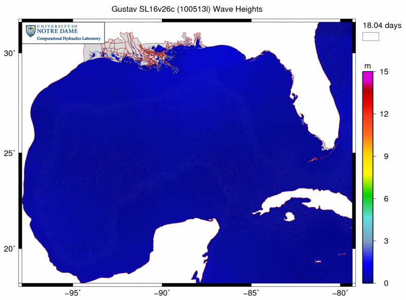
Note how the waves are generated in the deeper Gulf and then propagated onto the continental shelf, where they break due to changes in bathymetry and bottom roughness. The associated radiation stress gradients are passed from SWAN to ADCIRC and used to drive currents and set-up. Our new SL16 mesh contains significantly more resolution in all of the wave transformation zones, including mesh spacings of about 4km in deep water, 500m-1km on the entire shelf, and 100-200m in the breaking zones.
However, the water levels, currents and radiation stress gradients are not the only parameters that can be coupled integrally. This page describes how we have also coupled the bottom friction between the two model components. In SWAN, using the friction formulation of Madsen et al. (1988), we can vary the bottom rougness both spatially and temporally, by computing physical roughness lengths based on the Manning’s  coefficients used by ADCIRC.
How to Hot-Start SWAN+ADCIRC
Numerical models such as SWAN and ADCIRC can be started in different ways. The typical start is “cold,” i.e. with all computed quantities set to zero, and then the solution is allowed to develop naturally as the various forcings are applied. However, it is also possible to apply a “hot” start, in which the solution from a previous simulation is used as an initial condition. This page describes how to hot-start the tightly-coupled SWAN+ADCIRC.
As a point of discussion, please consider the following schematic of our hindcast validation of Hurricane Katrina:
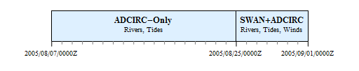
In our hurricane hindcasts, such as the validations of Katrina and Rita described in papers to be published in Monthly Weather Review, the simulations are performed in two stages. First, a spin-up simulation is run for several days before the start of the hurricane winds, so that the tides and rivers can reach a dynamic equilibrium in the resonant basin of the Gulf of Mexico. Then the solution from that spin-up simulation is used as the initial condition for the hurricane hindcast simulation. For example, for Katrina, we employ an 18-day, tides/rivers spin-up simulation that starts on 07 August 2005, and then we run a 7-day, hurricane simulation that starts on 25 August 2005. The solution from the spin-up simulation is used to hot-start the hurricane simulation.
There are two ways in which the coupled SWAN+ADCIRC could be hot-started during this hindcast. First, it is always hot-started at the beginning of its simulation, at 2005/08/25/0000Z. Although SWAN is not run during the tides/rivers spin-up simulation, because its action is forced entirely by the hurricane winds, we do run ADCIRC during that stage. Thus, when the coupled SWAN+ADCIRC model is employed in the second stage, we must hot-start the ADCIRC half of the simulation. SWAN starts from scratch at the beginning of the hurricane simulation.
Second, we may need to hot-start at some time during the SWAN+ADCIRC stage if it ended abruptly, due to machine failure, user interruption, etc. Instead of re-starting that stage at its beginning, we would rather hot-start in the middle. Then both SWAN and ADCIRC would need to be hot-started, using an intermediate solution as an initial condition for the remainder of the simulation.
Thus, there are two distinct methods in which SWAN+ADCIRC might be hot-started. The first method, in which SWAN is cold-started and ADCIRC is hot-started, would occur in the transition between simulations in the Katrina hindcast. The second method would hot-start both SWAN and ADCIRC, such as at some intermediate time during the second stage of the Katrina hindcast. Instructions for both methods are included below.