Posters: ASBPA Coastal Conference 2019

CA Rucker, N Tull, JC Dietrich, R Luettich, R Cyriac. “Improving the accuracy of a real-time ADCIRC storm surge downscaling model.ASBPA 2019 National Coastal Conference, Myrtle Beach SC, 23 October 2019.

Improving the accuracy of a real-time ADCIRC storm surge downscaling model.

JL Woodruff, JC Dietrich, AB Kennedy, D Wirasaet, D Bolster, Z Silver, RL Kolar. “Improving predictions of coastal flooding via sub-mesh corrections.ASBPA 2019 National Coastal Conference, Myrtle Beach SC, 23 October 2019.

Improving predictions of coastal flooding via sub-mesh corrections.

Continue reading

Carter Rucker helps with Pilot Study for DUNEX

CCHT member Carter Rucker joined a field pilot study with other members of the NCSU Coastal Engineering Team. The collaborative During Nearshore Event Experiment (DUNEX) pilot study is now underway along the Outer Banks of North Carolina, home to the U.S. Army Engineer Research and Development Center’s Coastal and Hydraulics Laboratory’s Field Research Facility.

DUNEX is a multi-agency, academic and non-governmental organization collaborative community experiment to study nearshore coastal processes during coastal storms. The multi-phase experiment plan begins with the pilot study, followed by the full experiment starting in fall 2020 and extending into winter 2021. Learn more here.

Carter Rucker (right) setting markers in the Pea Island marsh preparing for ADCP surveys later in the week. Photo courtesy Beth Sciaudone.

Presentation: ASCE NC Fall Conference

News: Modeling Florence’s Storm Surge

2019/04/26 – NCSU College of Engineering
After the Storm

ncsu-engr

Dr. Casey Dietrich, an assistant professor in the Department of Civil, Construction, and Environmental Engineering (CCEE), leads the Coastal and Computational Hydraulics Team and develops computational models that predict storm surge and coastal flooding. Using the model ADCIRC, the team makes predictions about how high sea waters will rise, which areas will be flooded and for how long. These predictions are made for the entire coastline, and then his team visualizes the flooding at the scales of individual buildings and coastal infrastructure. During Florence, Dietrich’s team and collaborators acted as liaisons for state emergency managers to aid their decision making.

“The models are just one data point among many, but they’re helpful in understanding hazards and used to make predictions in real time — partly to make decisions about evacuation, where to deploy resources after, safe places to put emergency vehicles and water supplies,” he said.

The state emergency managers are able to use the flooding predictions to get immediate estimates on damages, which helps communities that are figuring out how much recovery will cost.

After Hurricane Matthew in 2016, Dietrich and his colleagues improved the models’ ability to forecast encroaching water along shorelines. Post-Florence, Dietrich said the research focus is to speed up the model and allow for more permutations to see what might happen if a storm slows down or shifts direction.

Downscaling ADCIRC Flooding Inundation Extents Using Kalpana

Updated 2020/06/24: Added documentation for --growradius none option.

Updated 2020/04/15: Added documentation for DEM vertical unit conversions.

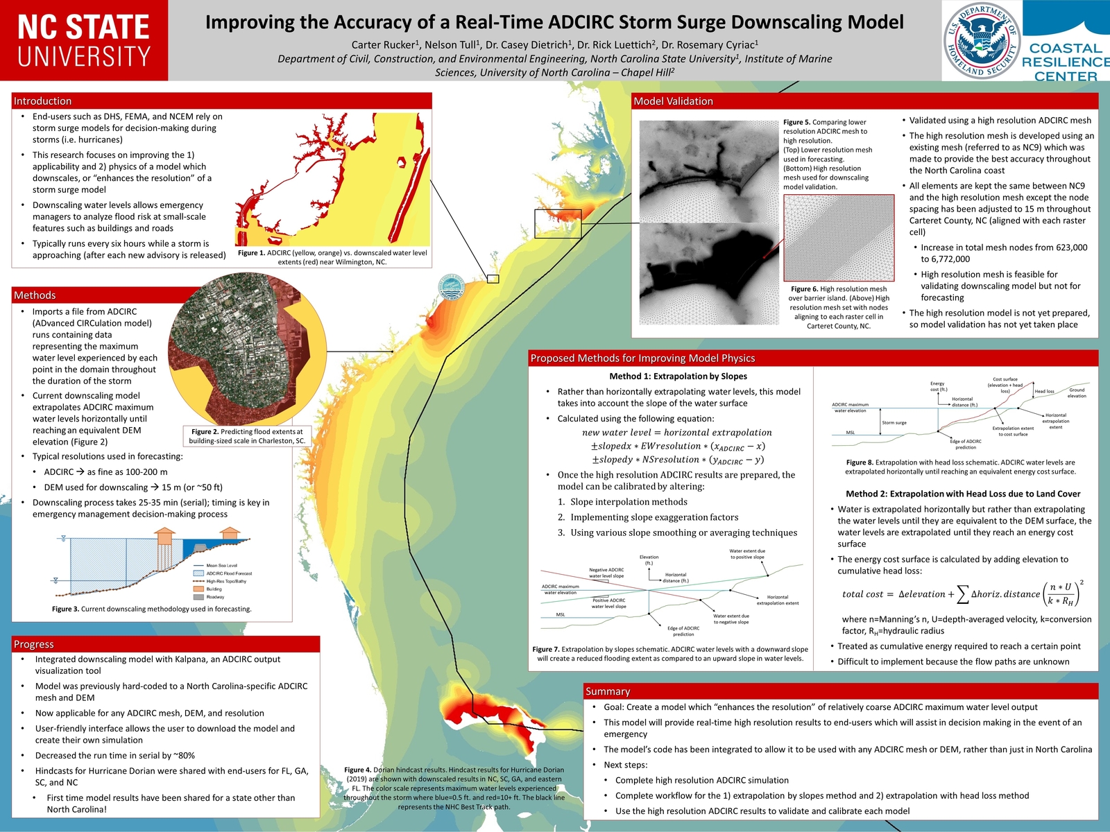
The ADCIRC modeling system is used often to predict coastal flooding due to tropical cyclones and other storms. The model uses high resolution to represent the coastal environment, including flow pathways (inlets, man-made channels, rivers) and hydraulic controls (barrier islands, raised features). However, due to the use of large domains to represent hazards on coastlines in an entire state or multiple states, the highest resolution is typically about 20 to 50 m in coastal regions. Thus, there is a potential gap between the flooding predictions and the true flooding extents. We have developed a geospatial software to downscale the flooding extents to higher resolution.

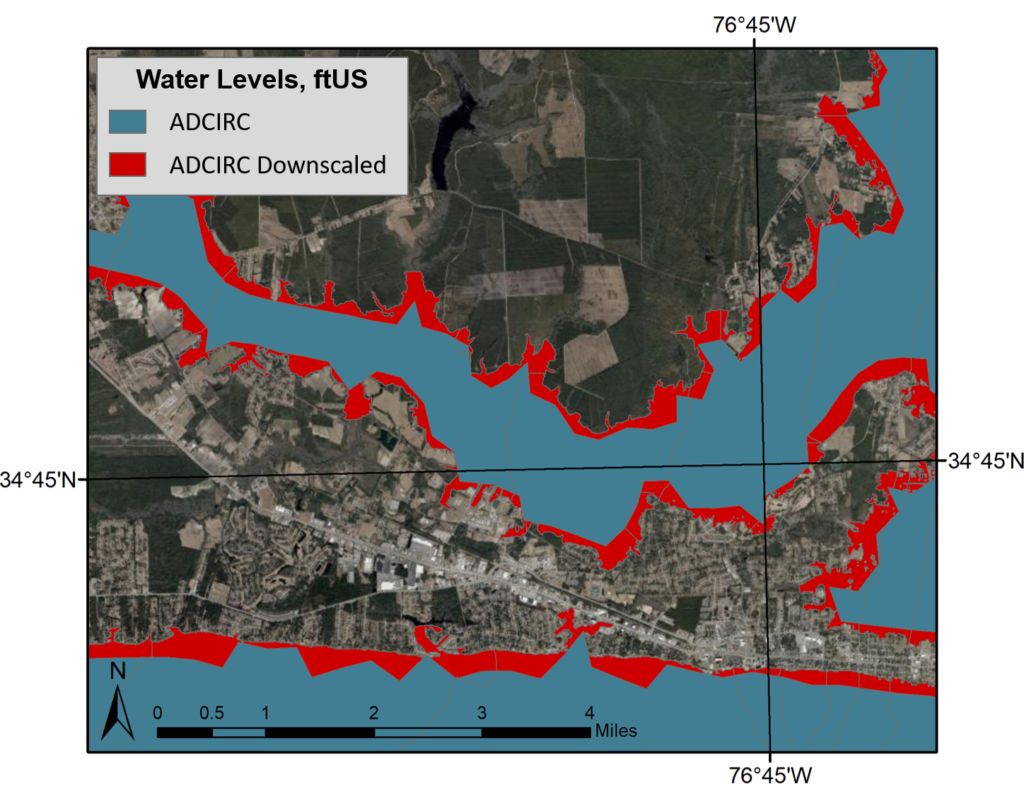
ADCIRC vs. downscaled water levels, plan view. This image shows the difference in prediction of flooding extents, with the blue portion representing the original ADCIRC flooding extents and red representing the downscaled extents.

The following documentation is for downscaling the flooding predictions by using Kalpana. This software was created originally to view ADCIRC outputs as either ESRI shapefiles or KML files (for viewing in Google Earth). ADCIRC (the ADvanced CIRCulation model) uses finite element methods to predict water levels throughout the modeled domain. Although this model is able to provide accurate predictions in a matter of minutes, these predictions have a limited resolution and are not able to provide information at the scale of buildings, roadways, and other critical infrastructure.

Continue reading