Storm-driven flooding is a severe hazard for coastal communities and regions. Computational models can predict the combined effects of tides, winds, and flooding due to tropical cyclones, including in real-time, but requirements for the models’ runtime make it challenging to consider simulations of the full range of storm uncertainty. To address this problem, researchers have developed neural networks, trained on libraries of storm surge simulations, to predict ensembles of coastal flooding in seconds. However, existing neural networks do not consider the interaction between storm surge and astronomical tides nor storms of any duration. Moreover, they are trained on datasets tailored to represent only extreme conditions. We aim to develop a neural network to predict the peak total water levels for any storm at specific locations along the North Carolina coast.
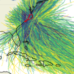 In this research, we implemented a neural network to predict peak values for total water level (tides and storm surge) at multiple stations, considering astronomical tides and storm tracks of any duration as inputs. To create the training library, we simulated 1,813 synthetic tropical cyclones based on historical data in the North Atlantic Ocean, with a specific focus on storms that affect North Carolina. These simulations used a full-physics hydrodynamic model with variable spatial resolution of about 50 m near the coast. The outputs were downscaled to grayscale images with a higher and constant resolution of 15 m, enhancing the flood predictions by considering small-scale topographic features, and then used as training data for the neural network. The many-to-one deep learning model predicts a single peak total water level in time at multiple locations in space using time series of the offshore astronomical tide and track parameters as inputs. We used the model to make probabilistic predictions of peak total water levels for observed and perturbed tracks of several historical storms that affected North Carolina.
 We showed that the neural network performed well (with errors ranging from 8 to 43 cm) in predicting peak total water levels at nine locations in North Carolina. We applied the neural network to make probabilistic predictions of peak total water levels for observed and perturbed tracks of historical storms. For each storm, the neural network predicted at nine stations for 101 storm scenarios (the true/historical storm and 100 perturbations) in less than 10 seconds. The performance for the observed historical storms was similar to those obtained in process-based simulations, but with a significant gain in computational runtime.
TA Cuevas López (2024). “Prediction of Peak Water Levels during Tropical Cyclones with Deep Learning,” North Carolina State University.


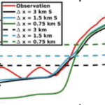 Compound flooding, the concurrence of multiple flooding mechanisms such as storm surge, heavy rainfall, and riverine flooding, poses a significant threat to coastal communities. To mitigate the impacts of compound flooding, forecasts must represent the variability of flooding drivers over a wide range of spatial scales while remaining timely. One approach to develop these forecasts is through subgrid corrections, which utilize information at smaller scales to “correct” water levels and current velocities averaged over the model scale. Recent studies have shown that subgrid models can improve both accuracy and efficiency; however, existing models are not able to account for the dynamic interactions of hydrologic and hydrodynamic drivers and their contributions to flooding along the smallest flow pathways when using a coarse resolution. Here, we have developed a solver called CoaSToRM (Coastal Subgrid Topography Research Model) with subgrid corrections to compute compound flooding in coastal systems resulting from fluvial, pluvial, tidal, and wind-driven processes. A key contribution is the model’s ability to enforce all flood drivers and use the subgrid corrections to improve the accuracy of the coarse-resolution simulation. The model is validated for Hurricane Eta 2020 in Tampa Bay, showing improved prediction accuracy with subgrid corrections at 42 locations. Subgrid models with coarse resolutions (R2 = 0.70, 0.73, 0.77 for 3-, 1.5-, 0.75-km grids) outperform standard counterparts (R2 = 0.03, 0.14, 0.26). A 3-km subgrid simulation runs roughly 50 times faster than a 0.75-km subgrid simulation, with similar accuracy.
 Undergraduate student Brandon Tucker won an Outstanding Senior Award for Scholarly Achievement, which recognizes exceptional academic performance including participation in undergraduate research. Brandon was among four outstanding seniors