FigureGen v.41

Updated 2012/06/05: This version of FigureGen has become outdated, but is maintained on this page for reference. Please click here to be redirected to the newest version.

FigureGen is a FORTRAN program that creates images for ADCIRC files. It reads output files (fort.63, fort.64, maxele.63, etc.), grid files (fort.14, etc.), nodal attributes files (fort.13), etc. It plots contours, contour lines, and vectors. Using FigureGen, you can go directly from the ADCIRC input and output files to a presentation-quality figure, for one or multiple time snaps, without having to use SMS.

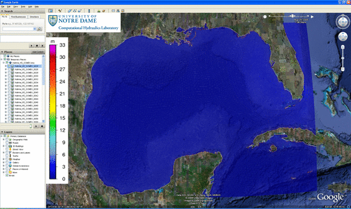
The following example depicts the water levels in ArcGIS as Ike moved through the Gulf:

Contours of water levels (m) in the Gulf of Mexico during Ike (2008), as visualized in ArcGIS.

Contours of water levels (m) in the Gulf of Mexico during Ike (2008), as visualized in ArcGIS.

This program started from a script written by Brian Blanton, and it contains code written by John Atkinson, Howard Lander, Chris Szpilka, Zach Cobell, and others. I converted it to FORTRAN because I am more familiar with that language, and I added the capability to plot vectors, among other things. But, at its core, FigureGen behaves like a script, and it uses system calls to tell other software how to generate the figure(s).

Continue reading

FigureGen v.32

Updated 2012/06/05: This version of FigureGen has become outdated, but is maintained on this page for reference. Please click here to be redirected to the newest version.

FigureGen is a FORTRAN program that creates images for ADCIRC output files. It reads sparse (fort.63, fort.64, etc.) and full (maxele.63, maxwvel.63, etc.) output files, grid (fort.14, etc.) files, and nodal attributes (fort.13) files. It plots contours, contour lines, and vectors. Using FigureGen, you can go directly from the ADCIRC input and output files to a presentation-quality figure, for one or multiple time snaps, without having to use SMS.

The following example depicts the significant wave heights during Hurricane Katrina in the Gulf of Mexico:

Significant wave heights (m) during Katrina (2005) in the Gulf of Mexico.

Significant wave heights (m) during Katrina (2005) in the Gulf of Mexico.

This program started from a script written by Brian Blanton. I converted it to FORTRAN because I am more familiar with that language, and I added the capability to plot vectors, among other things. But, at its core, FigureGen behaves like a script, and it uses system calls to tell other software how to generate the figure(s).

Continue reading

FigureGen v.26

Updated 2012/06/05: This version of FigureGen has become outdated, but is maintained on this page for reference. Please click here to be redirected to the newest version.

FigureGen is a FORTRAN program that creates images for ADCIRC output files. It reads sparse (fort.63, fort.64, etc.) and full (maxele.63, maxwvel.63, etc.) output files, grid (fort.14, etc.) files, and nodal attributes (fort.13) files. It plots contours, contour lines, and vectors. Using FigureGen, you can go directly from the ADCIRC input and output files to a presentation-quality figure, for one or multiple time snaps, without having to use SMS.

The following example depicts the wind reduction factors for our hurricane runs in southeast Louisiana:

Directional wind reduction factors in the northern Gulf of Mexico.

Directional wind reduction factors in the northern Gulf of Mexico.

This program started from a script written by Brian Blanton. I converted it to FORTRAN because I am more familiar with that language, and I added the capability to plot vectors, among other things. But, at its core, FigureGen behaves like a script, and it uses system calls to tell other software how to generate the figure(s).

Continue reading