 The combined impact of hurricanes and climate change can affect the total water level leading to severe impacts on coastal zones such as flooding. Accurate prediction and evaluation of water levels are essential for predicting the impact on military readiness and resilience for coastal facilities. This study uses D-Flow Flexible Mesh to evaluate the sensitivity of water level and flood area prediction to the impact of climate change and hurricane activity with application to the Naval Station Norfolk, Virginia, USA.
The water level (tide and surge) was simulated and the potential flooding resulting from historical hurricanes (Irene and Isabel) in Norfolk, VA was evaluated. The model was forced using the parametric Holland Model and various perturbations in the hurricane characteristics were evaluated. In addition, projected relative sea level rise up to the year 2150 was investigated.
D-Flow can accurately simulate the water level with an average correlation coefficient and root-mean-square-error of 0.974 and 0.17 m, respectively. Water level prediction showed high sensitivity to climate change impacts and inaccuracies in hurricane track and lower sensitivity to changes in hurricane central pressure and radius of maximum wind. A mesh resolution that reflects accurate topographical depiction is required to estimate the flood area accurately. Willoughby Spit (a narrow peninsula north of the naval base extending into Chesapeake Bay) was the most susceptible area to flooding. Significant parts of the base were found to be vulnerable to flooding under the considered scenarios, with flood areas ranging from 0.28 km2 to 5.94 km2 (1.3%–43% of the base area), with the largest predicted flooding for the sea level rise and wind speed scenarios. The insights of the sensitivity of flood predictions to various factors could enable targeted adaptation measures and resource allocation, for enhanced resilience and sustainable development in vulnerable coastal areas.


 With sea-level rise, flooding in coastal communities is now common during the highest high tides. Floods also occur at normal tidal levels when rainfall overcomes stormwater infrastructure that is partially submerged by tides. Data describing this type of compound flooding is scarce and, therefore, it is unclear how often these floods occur and the extent to which non-tidal factors contribute to flooding. We combine measurements of flooding on roads and within storm drains with a numerical model to examine processes that contribute to flooding in Carolina Beach, NC, USA — a community that chronically floods outside of extreme storms despite flood mitigation infrastructure to combat tidal flooding. Of the 43 non-storm floods we measured during a year-long study period, one-third were unexpected based on the tidal threshold used by the community for flood monitoring. We introduce a novel model coupling between an ocean-scale hydrodynamic model (ADCIRC) and a community-scale surface water and pipe flow model (3Di) to quantify contributions from multiple flood drivers. Accounting for the compounding effects of tides, wind, and rain increases flood water levels by up to 0.4 m compared to simulations that include only tides. Setup from sustained (non-storm) regional winds causes deeper, longer, more extensive flooding during the highest high tides and can cause floods on days when flooding would not have occurred due to tides alone. Rainfall also contributes to unexpected floods; because tides submerge stormwater outfalls on a daily basis, even minor rainstorms lead to flooding as runoff has nowhere to drain. As a particularly low-lying coastal community, Carolina Beach provides a glimpse into future challenges that coastal communities worldwide will face in predicting, preparing for, and adapting to increasingly frequent flooding from compounding tidal and non-tidal drivers atop sea-level rise.
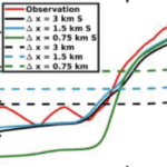 Compound flooding, the concurrence of multiple flooding mechanisms such as storm surge, heavy rainfall, and riverine flooding, poses a significant threat to coastal communities. To mitigate the impacts of compound flooding, forecasts must represent the variability of flooding drivers over a wide range of spatial scales while remaining timely. One approach to develop these forecasts is through subgrid corrections, which utilize information at smaller scales to “correct” water levels and current velocities averaged over the model scale. Recent studies have shown that subgrid models can improve both accuracy and efficiency; however, existing models are not able to account for the dynamic interactions of hydrologic and hydrodynamic drivers and their contributions to flooding along the smallest flow pathways when using a coarse resolution. Here, we have developed a solver called CoaSToRM (Coastal Subgrid Topography Research Model) with subgrid corrections to compute compound flooding in coastal systems resulting from fluvial, pluvial, tidal, and wind-driven processes. A key contribution is the model’s ability to enforce all flood drivers and use the subgrid corrections to improve the accuracy of the coarse-resolution simulation. The model is validated for Hurricane Eta 2020 in Tampa Bay, showing improved prediction accuracy with subgrid corrections at 42 locations. Subgrid models with coarse resolutions (R2 = 0.70, 0.73, 0.77 for 3-, 1.5-, 0.75-km grids) outperform standard counterparts (R2 = 0.03, 0.14, 0.26). A 3-km subgrid simulation runs roughly 50 times faster than a 0.75-km subgrid simulation, with similar accuracy.