Poster: NCSU Symposiums 2015

R Cyriac, JC Dietrich, JG Fleming, BO Blanton, RA Luettich, C Kaiser. “Forecast Predictions of Winds, Waves and Storm Surge during Hurricane Arthur (2014).” Graduate Student Research Symposium, North Carolina State University, 25 March 2015.

R Cyriac, JC Dietrich, JG Fleming, BO Blanton, RA Luettich, C Kaiser. “Forecast Predictions of Winds, Waves and Storm Surge during Hurricane Arthur (2014).Environmental, Water Resources and Coastal Engineering Research Symposium, North Carolina State University, 06 March 2015.

Rosemary_Poster_WREESymposium_2015

News: Developing Storm Surge Visualization

2014/10/29 – NC Sea Grant Coastwatch Currents
Picture This: Developing Storm Surge Visualization

ncsg

When a tropical storm or hurricane develops in the open ocean, the National Hurricane Center, known as NHC, issues advisories that anticipate the track and intensity of the wind field. These advisories predict when and where the hurricane is expected to make landfall, even when the storm is far away from the coast.

This information serves as an input for the ocean model, which then predicts the water levels or storm surges, and wave heights created by these winds at various locations along our coastline for the coming days. These results will convey a greater meaning to the end user when visualized properly. The chief objective for our project is to improve the communication of these model outputs to the end-user by producing them in popular file formats like that of GIS based shapefiles and KMZ files used in Google Earth.

News: Sea Change

2014/05/28 – NC State Engineering Magazine
Working with one of North Carolina’s most valuable resources

ncsu-engr

Dietrich came to NC State with a wealth of experience in coastal modeling, most of it done along the Gulf Coast of the United States. He will soon begin a project with the National Oceanic and Atmospheric Administration to model North Carolina’s coast. Dietrich is part of a research community using a computer model called ADCIRC to predict everything from storm surge and flooding to the feasibility of dredging, or where material floating in the ocean might end up.

When a hurricane is bearing down on the coastline, running the models quickly is of the essence. But the faster the model runs, the less accurate it is. Improving the models so that the time and accuracy trade-off isn’t as sharp is part of Dietrich’s work.

So is figuring out the best ways to visualize the results and get the modeling information to local emergency management officials along the coast so that they can use it.

“It doesn’t help anybody if we are doing this in an empty room somewhere and not sharing the results with the community and sharing them in a way that will maximize their use and maximize their impact,” he said.

Continue reading

News: Hazard Resilience in Coastal Communities

2014/05/14 – North Carolina Sea Grant Coastwatch
Coastal Science Serves North Carolina: Sea Grant Funds New Research Projects

ncsg

Using a high-resolution modeling system, the researchers will expand the utility and accuracy of wave, storm-surge and flooding forecast guidance available to emergency managers in North Carolina. The accurate prediction of these elements is essential for the safety of people and property.

Strengthening the Hurricane Wave and Surge Forecast Guidance provided to Coastal Communities in North Carolina

NCSG-ProposalThis proposal seeks funds to expand the utility and accuracy of wave, storm surge and flooding forecast guidance that is available to emergency managers in North Carolina using a high-resolution modeling system. Through discussions with them, the guidance from the forecast system will be targeted to their needs, so they can better utilize it while also understanding its strengths and limitations. In addition, the modeled representation of the North Carolina coastal waters will be enhanced to increase accuracy in specific regions of interest.

North Carolina is particularly sensitive to waves, storm surge and flooding, given its geographic location and the protrusion of its coastline into the Atlantic. Severe storms such as hurricanes and nor-easters can devastate the natural and built environment along the complex system of barrier islands, bays and estuaries, and communities that comprise our coast. Several storms have caused flooding in recent years, including but not limited to Bertha and Fran (1996), Floyd (1999), Isabel (2003), Irene (2011) and Sandy (2012). The accurate prediction of waves, storm surge and flooding is essential for evacuation and protection of life and property.

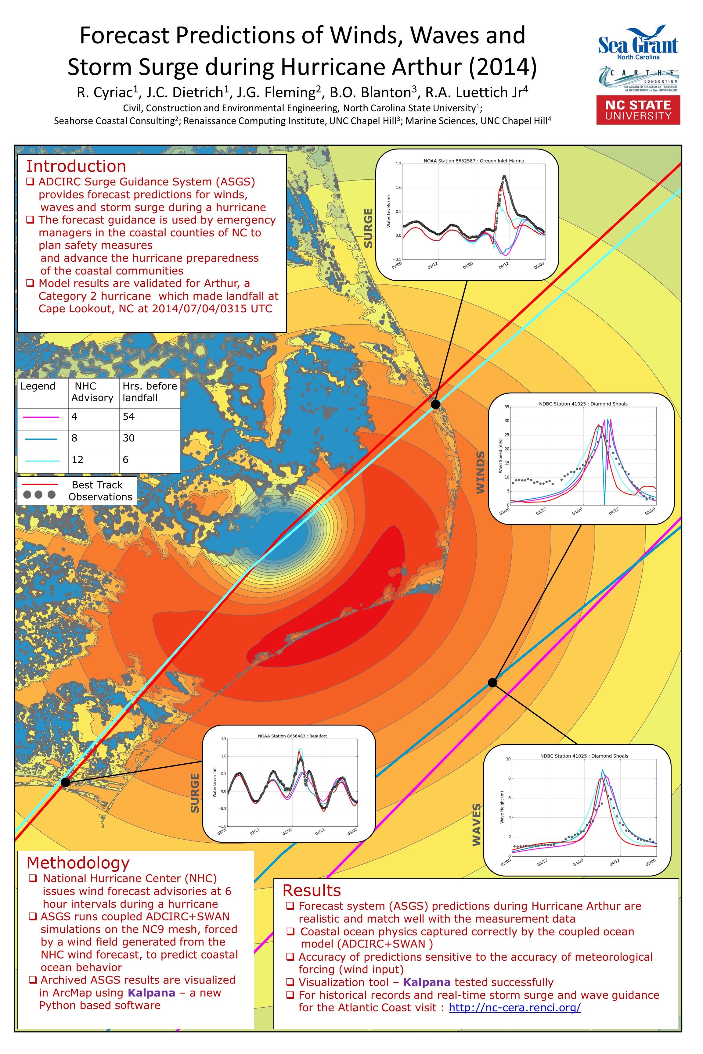
A computational modeling system for North Carolina has been established for forecasting of waves, surge and flooding at high resolution using high-performance computing resources. The models have been validated extensively and applied recently for the analysis of the levee protection system near New Orleans, and the development of new flood risk maps for the Gulf and Atlantic coasts. Within North Carolina, these models are utilized operationally to provide forecast guidance every day for coastal waves and inundation (http://nc-cera.renci.org/).

In this proposed research, the forecast guidance from this modeling system will be expanded beyond Web-based delivery to include additional formats that are targeted to the needs of users within the state. These new formats will represent the guidance at high levels of geographic resolution and will be portable, so users can combine and compare the forecasts with information from other sources. In addition, by identifying regions of interest to them, the models will evolve to improve accuracy in their description of the coastal environment. The resulting guidance will be more powerful because it will be placed directly into the hands of stakeholders who will have participated in its development.

JC Dietrich, BO Blanton, JG Fleming, JL Losego, RA Luettich Jr (2014-2016). “Strengthening the Hurricane Wave and Surge Forecast Guidance provided to Coastal Communities in North Carolina.National Oceanic and Atmospheric Administration, North Carolina Sea Grant, 2014/02/01 to 2016/01/31, $143,358 (Dietrich: $108,358).