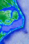
 This proposal seeks funds to expand the utility and accuracy of wave, storm surge and flooding forecast guidance that is available to emergency managers in North Carolina using a high-resolution modeling system. Through discussions with them, the guidance from the forecast system will be targeted to their needs, so they can better utilize it while also understanding its strengths and limitations. In addition, the modeled representation of the North Carolina coastal waters will be enhanced to increase accuracy in specific regions of interest.
North Carolina is particularly sensitive to waves, storm surge and flooding, given its geographic location and the protrusion of its coastline into the Atlantic. Severe storms such as hurricanes and nor-easters can devastate the natural and built environment along the complex system of barrier islands, bays and estuaries, and communities that comprise our coast. Several storms have caused flooding in recent years, including but not limited to Bertha and Fran (1996), Floyd (1999), Isabel (2003), Irene (2011) and Sandy (2012). The accurate prediction of waves, storm surge and flooding is essential for evacuation and protection of life and property.
A computational modeling system for North Carolina has been established for forecasting of waves, surge and flooding at high resolution using high-performance computing resources. The models have been validated extensively and applied recently for the analysis of the levee protection system near New Orleans, and the development of new flood risk maps for the Gulf and Atlantic coasts. Within North Carolina, these models are utilized operationally to provide forecast guidance every day for coastal waves and inundation (http://nc-cera.renci.org/).
In this proposed research, the forecast guidance from this modeling system will be expanded beyond Web-based delivery to include additional formats that are targeted to the needs of users within the state. These new formats will represent the guidance at high levels of geographic resolution and will be portable, so users can combine and compare the forecasts with information from other sources. In addition, by identifying regions of interest to them, the models will evolve to improve accuracy in their description of the coastal environment. The resulting guidance will be more powerful because it will be placed directly into the hands of stakeholders who will have participated in its development.

