Category Archives: DOD ESTCP 2022-2026
News: Department Social Media
YouTube
 Jack Voight was featured on social media in a video about his summer research in our REU program. He is running simulations of storm surge and coastal flooding as part of a project about total water levels at coastal infrastructure. Glad he is part of our team!
Poster: EWC Symposium 2023
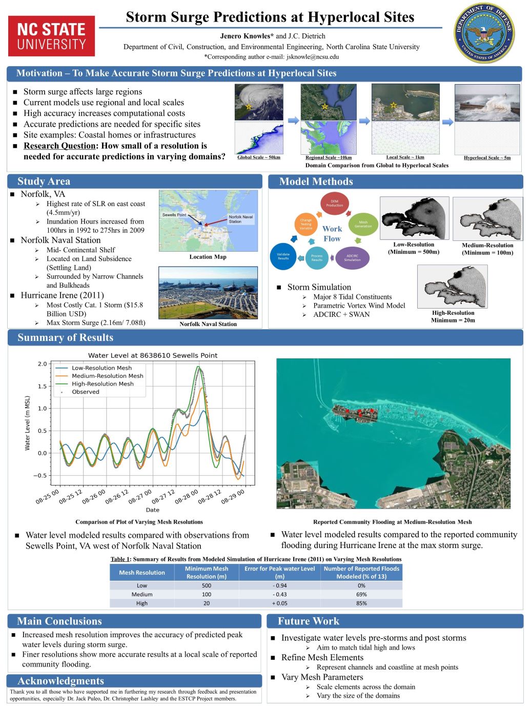
JS Knowles, JC Dietrich. “Storm Surge Predictions at Hyperlocal Sites“. Environmental, Water Resources, and Coastal Engineering Research Symposium, North Carolina State University, 10 March 2023.

Storm Surge Predictions at Hyperlocal Sites
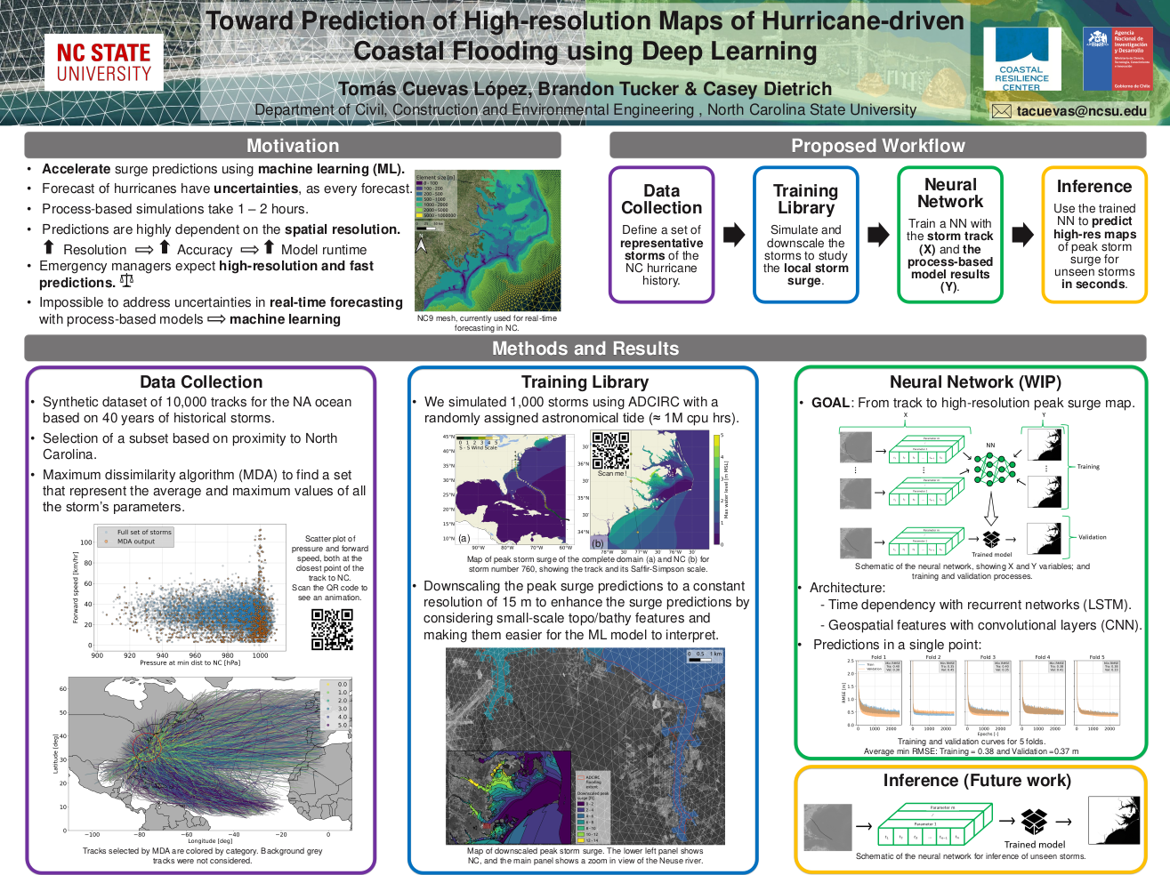
TA Cuevas López, BJ Tucker, JC Dietrich. “Toward Prediction of High-resolution Maps of Hurricane-driven Coastal Flooding using Deep Learning“. Environmental, Water Resources, and Coastal Engineering Research Symposium, North Carolina State University, 10 March 2023.
News: Preparing for a Changing Climate
UD civil engineers lead research to examine models for coastal readiness at U.S. military bases
![]()
University of Delaware civil engineers are leading a multi-institutional effort to identify the best models to calculate flood risk at coastal military installations where climate change threatens to increase the risk of flood damage from sea level rise and storm surge.
The four-year project, which launched in mid-2022 and will run through spring 2025, is funded by a $2.2 million grant from the U.S. Department of Defense (DoD). Project partners include faculty and students from the Netherlands, North Carolina State University, the University of South Alabama, Texas A&M and the United States Geological Survey (USGS).
…
“The goal is to provide guidance to the DoD about the strengths and weaknesses of each model in comparison. They’re all going to have things they’re good with and things they struggle with,” Dietrich said. Those comparisons will help the agencies decide what types of models they want to use to get what types of information — depending on how much time, effort and funding they want to commit.
There’s also a goal of reducing cost and building smarter models, he said.
“If we are able to improve our predictions at very specific sites along the coast, we also can have better predictions at other specific sites along the coast, like someone’s house or a bridge or other infrastructure,” Dietrich said.
Conference: YCSECA 2022
Comparative Assessment of Total Water Levels for Coastal Military Facility Readiness and Resilience using Numerical Models
JA Puleo, JC Dietrich, J Figlus, K Nederhoff, F Shi, SM Smallegan, CD Storlazzi, A van Dongeren. “Comparative assessment of total water levels for coastal military facility readiness and resilience using numerical models.” Department of Defense, Environmental Security Technology Certificate Program, 2022/04/13 to 2026/04/12, $2,177,000 (Dietrich: $346,000).


