

Category Archives: XBeach
Deterministic, Dynamic Model Forecasts of Storm‑Driven Coastal Erosion
 The U.S. Atlantic and Gulf of Mexico coasts are vulnerable to storms, which can cause significant erosion of beaches and dunes that protect coastal communities. Real-time forecasts of storm-driven erosion are useful for decision support, but they are limited due to demands for computational resources and uncertainties in dynamic coastal systems and storm forcings. Current methods for coastal change forecasts are based on empirical calculations for wave run-up and conceptual models for erosion, which do not represent sediment transport and morphological change during the storm. However, with continued advancements in high-resolution geospatial data and computational efficiencies, there is an opportunity to apply morphodynamic models for forecasts of beach and dune erosion as a storm approaches the coast. In this study, we implement a forecast system based on a deterministic, dynamic model. The morphodynamic model is initialized with digital elevation models of the most up-to-date conditions and forced with hydrodynamics from wave and circulation model forecasts, and its predictions are categorized based on impact to the primary dune, defined in this study as the first ridge of sand landward of the beach. Results are compared spatially to the observed post-storm topography using changes to dune crest elevations and volumes, and temporally to the predicted total water level at the forecasted moment of dune impact.
Nahruma wins People’s Choice Award at EWC Symposium
Nahruma Pieu won the People’s Choice Award at the Environmental, Water Resources, and Coastal (EWC) Engineering Graduate Research Symposium, hosted by the Department of Civil, Construction, and Environmental Engineering (CCEE) at NC State University. She was one of two presenters to win the award, which was voted by attendees at the symposium.

Nahruma received the People’s Choice Award from CCEE Department Head, Dr. Gibson.
“I’m thankful that my work was well received by the community,” Nahruma said. “I’m especially grateful to my advisor, Dr. Casey Dietrich, whose guidance and support made this possible. I’m also thankful to the National Oceanographic Partnership Program (NOPP) for funding my work on predicting coastal dune erosion, which will be necessary given our recent climate change scenario, as storms increase in frequency and intensity.”
Congratulations to Nahruma!
Posters: EWC Symposium 2025
NK Arrigo, JC Dietrich, TC Massey. “Spatial controls and efficiency gains within a spectral wave model.” Environmental, Water Resources, and Coastal Engineering Graduate Research Symposium, North Carolina State University, 21 Mar 2025.
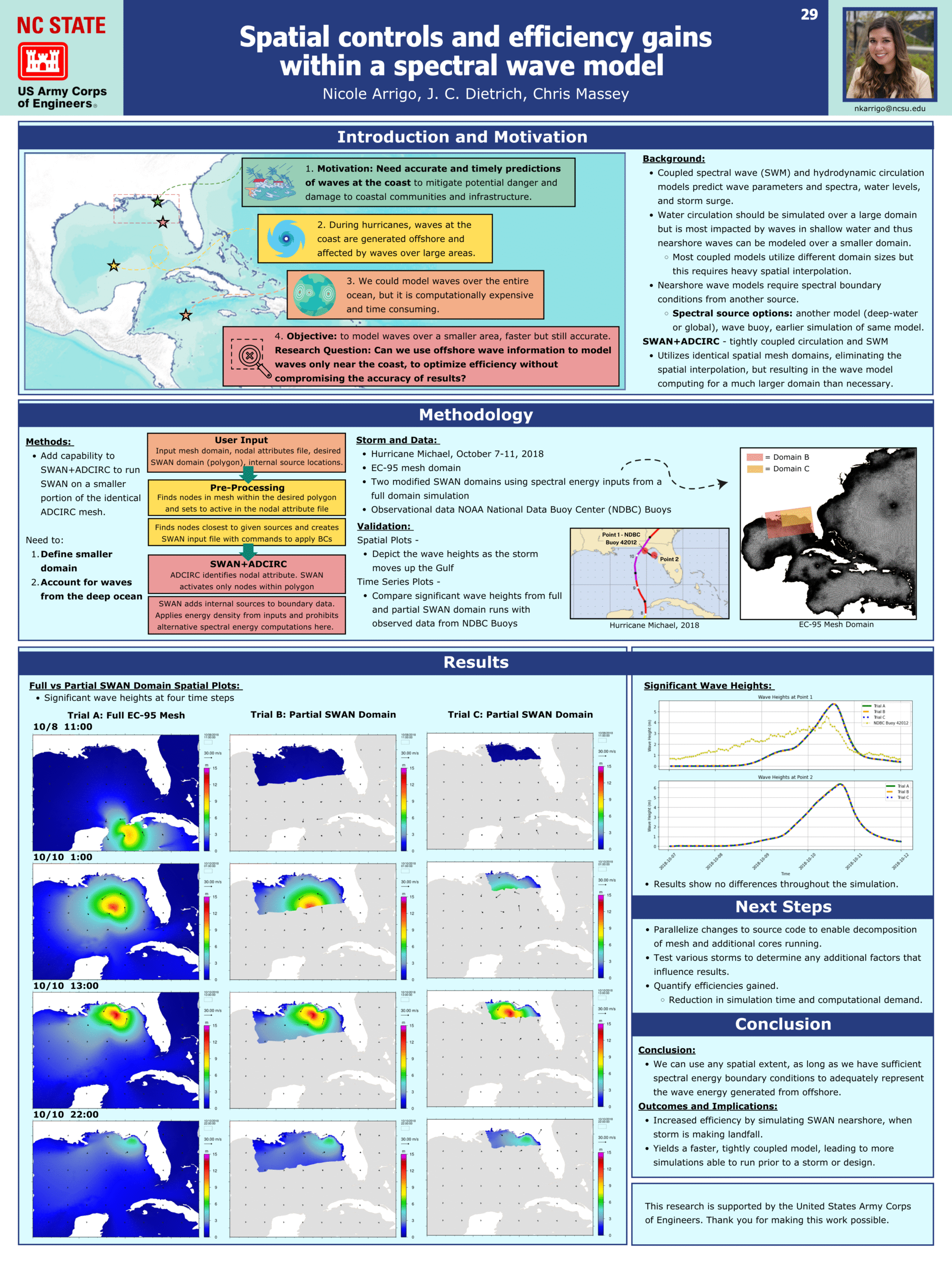
Spatial controls and efficiency gains within a spectral wave model.
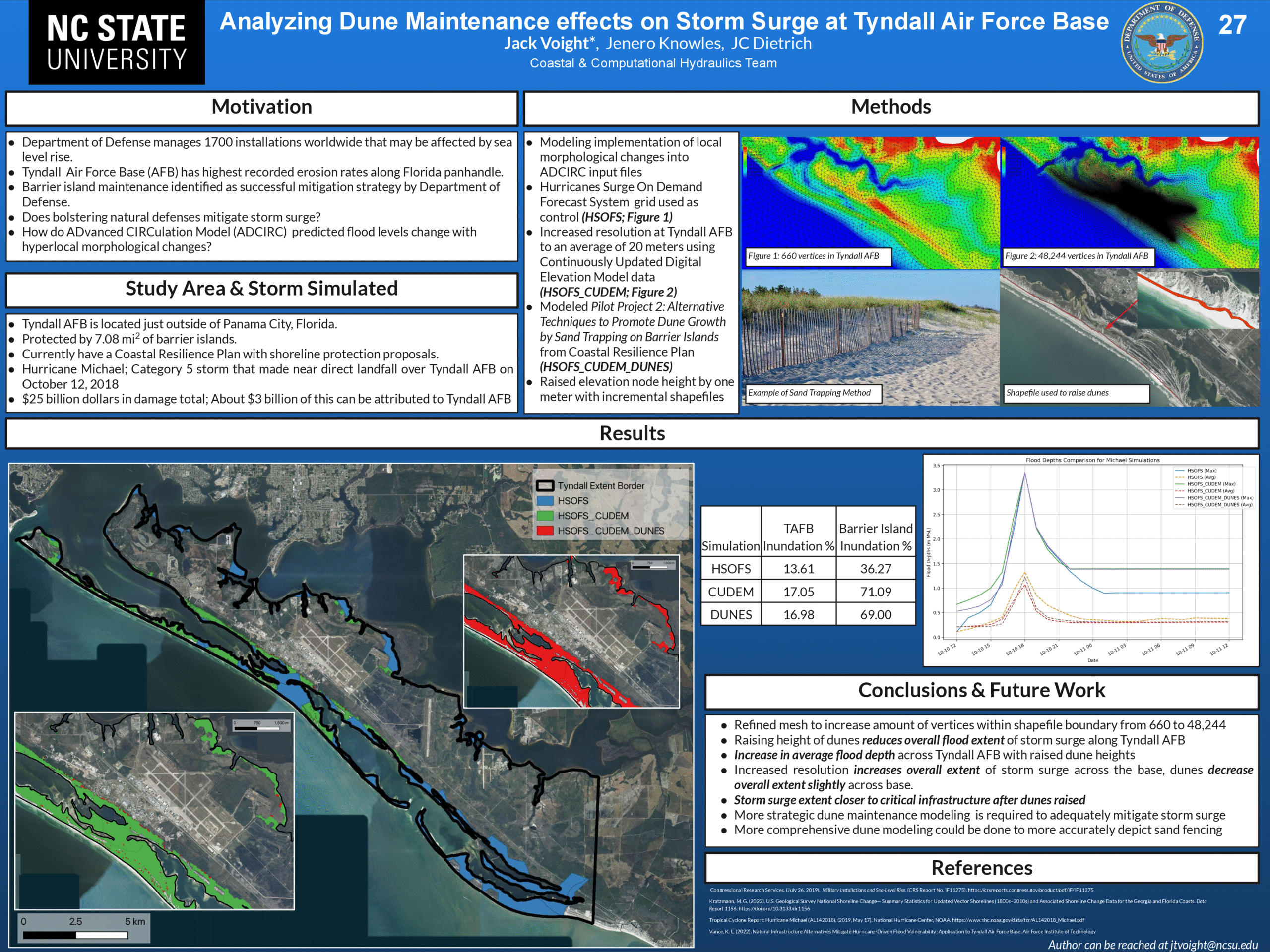
Analyzing Dune Maintenance effects on Storm Surge at Tyndall Air Force Base.
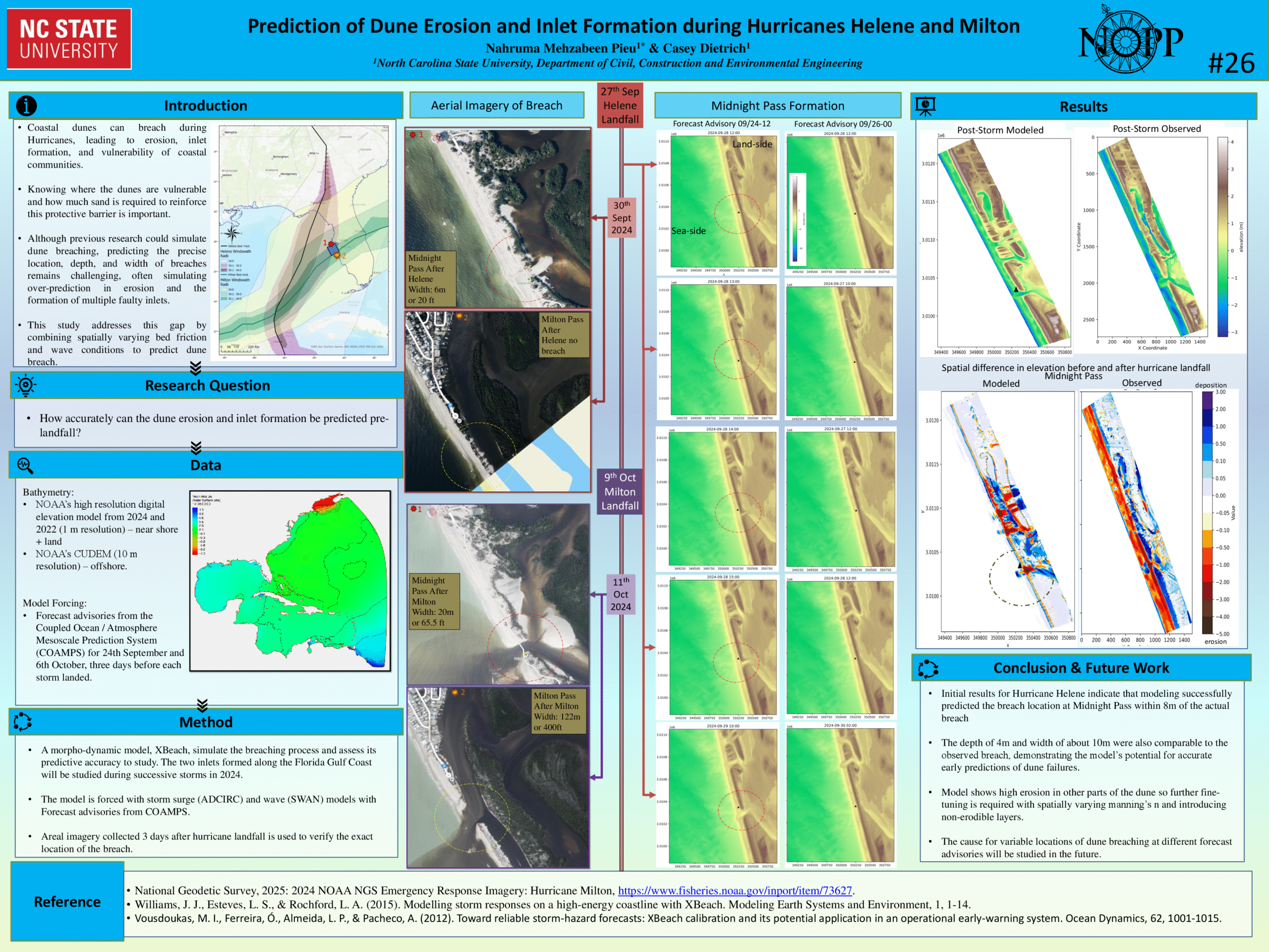
Prediction of Dune Erosion and Inlet Formation during Hurricanes Helene and Milton.
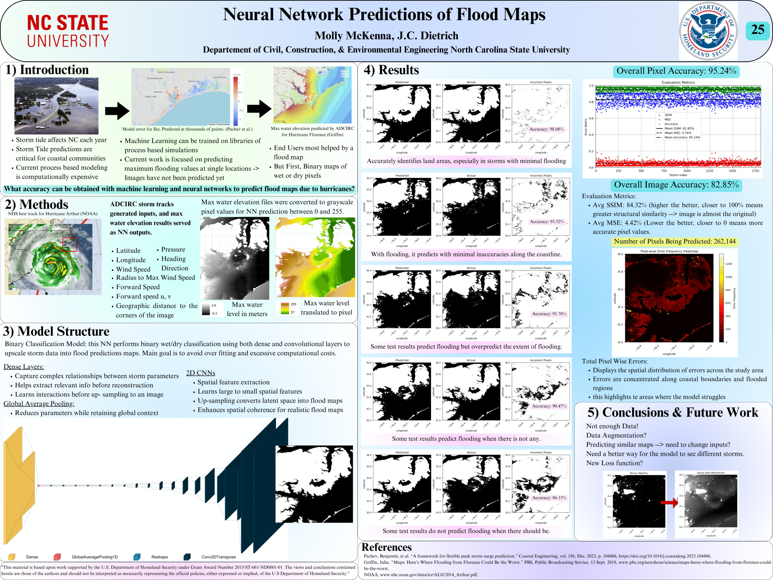
Neural Network Predictions of Flood Maps
News: Erosion Forecast Framework
2025/01/22 – NCSU Civil, Construction, and Environmental Engineering
New technology forecasts beach and dune erosion before hurricanes strike
New technology forecasts beach and dune erosion before hurricanes strike

“Physics-based models can predict how the dune may be lowered, and how much water may flood behind it,” said Jess Gorski (MS 2023), who worked with Professor Casey Dietrich on the project. “Our forecasts can provide information about coastal change to decision makers during a storm.”
In collaboration with the USGS, CCEE researchers developed a framework for running the eXtreme Beach (XBeach) model in real time. The U.S. Gulf and Atlantic coasts are described with thousands of transects, which quantify the offshore depths and the shape of the beach and dune at intervals of 500 m to 2 km along the coast. When a storm approaches, the framework can select the transects that may be affected, and then run a few hundred simulations of the coastal erosion.
Conference : YCSECA 2024
Deterministic, Dynamic Model Forecasts of Storm-Driven Erosion
The U.S. Atlantic and Gulf coasts are vulnerable to storms, which can cause significant erosion of beaches and dunes that otherwise protect coastal communities. One example is Hurricane Ian (2022), which impacted Florida’s Gulf coast and then again the southeast U.S. Atlantic coast, resulting in significant beach and dune scarping and breaches in multiple locations. Models can be used for real-time forecasts of storm-driven erosion, which can support decision-making, but are limited due to demands for computational resources and uncertainties in dynamic coastal systems. Current methods for erosion forecasts are based on empirical equations for wave run-up, which do not represent sediment transport during the storm, and on surrogate models, which also must rely on simplified representations of the system. However, with continued advancements in high-resolution geospatial data and computational efficiencies, there is an opportunity to apply morphodynamic models for deterministic forecasts of beach and dune erosion as a stormapproaches the coast. Real-time morphodynamic model implementation is challenging because the framework must be accurate and efficient while maintaining versatility to account for forecast uncertainties. Additionally, the evaluation and post-processing for the model needs to effectively communicate the results, including the timing and scale of coastal change during an extreme event when temporal observations are unavailable.
 In this study, we apply the state-of-art model eXtreme Beach (XBeach) to predict coastal erosion due to Hurricanes Michael (2018) and Ian (2022). Sandy beaches along the U.S. Atlantic and Gulf coasts are represented with thousands of one-dimensional transects, which are sampled for real-time forecasts based on the storms’ tracks and projected landfall locations. The morphodynamic model is initialized with high-resolution digital elevation models of the present-day conditions and forced with hydrodynamics from high-resolution wave and circulation models, and its predictions are categorized based on impacts to the primary dune. A key contribution of this study is the semi-automation of the modeling system, so the modeling framework can be applied to different regions of the coast as the landfall location shifts.
 To demonstrate this, forecasts for Ian (2022) were initiated several days before the initial landfall location in Punta Gorda, Florida, and continued as the track made a secondary landfall near Georgetown, South Carolina. About 1800 transects are selected for each of the 25 advisories. The simulations are monitored, evaluated, and visualized to communicate the XBeach predictions of coastal change. The framework produces results in less than an hour and then publishes visualizations in less than 10 minutes. Results are compared spatially and temporally to qualitative post-Ian observations and total water level predictions. XBeach can predict dune impact compared to an established coastal change forecasting model while providing additional morphodynamic information not typically available, such as timing and magnitude of volume change. The addition of fully resolved ground surface information and morphodynamics in the model makes it possible to better understand the storm evolution and how that translates into erosion of beaches and dunes.
Jessica Gorski defends MS Thesis
We celebrate another successful defense! Jess defended her MS thesis to a mix of in-person and remote attendees, who had a lot of interest in her research on real-time forecasts of coastal erosion. Congrats to Jess!
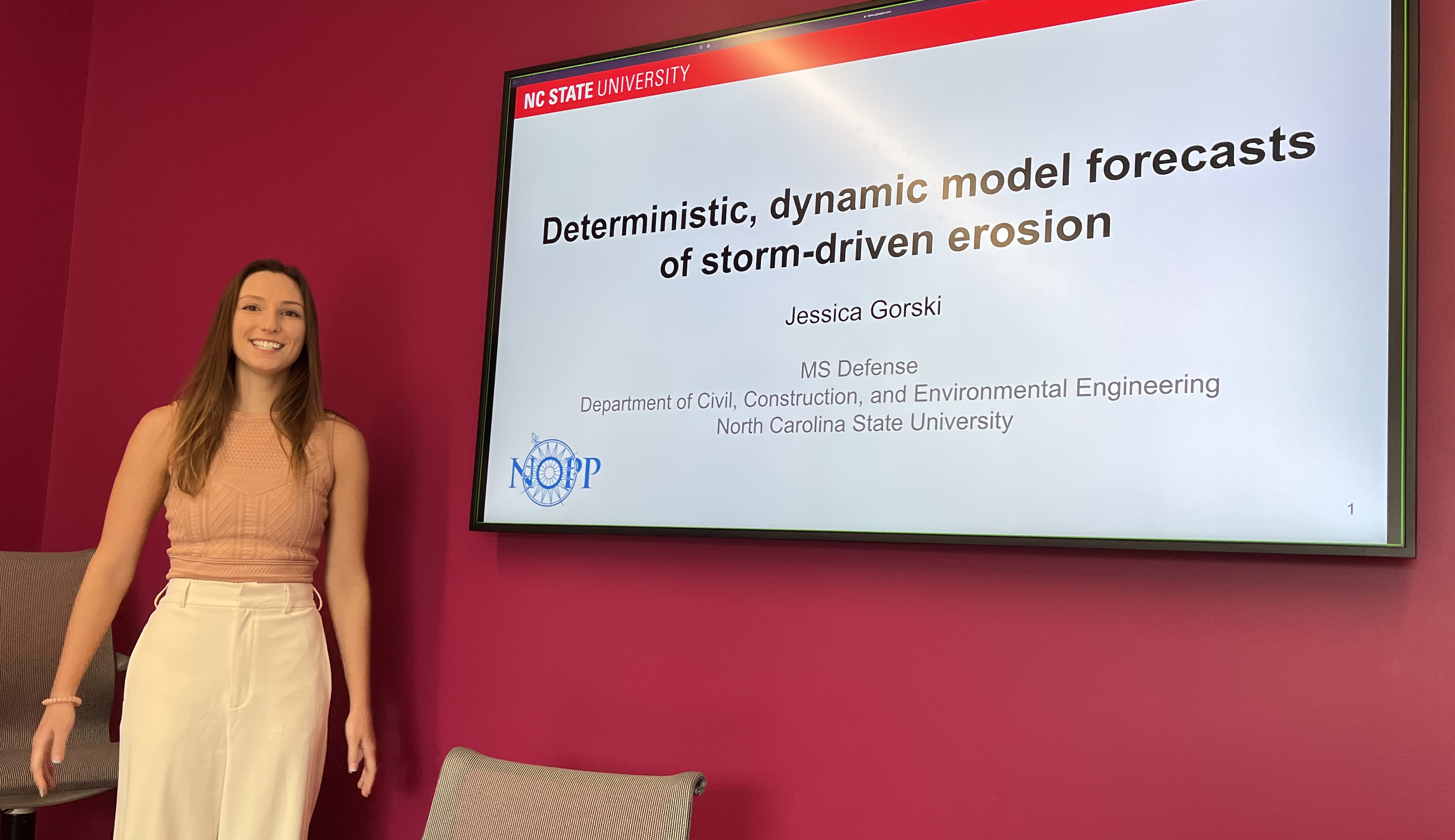
Jessica starts her thesis defense.