

Category Archives: Models
Poster: EWC Symposium 2023
JS Knowles, JC Dietrich. “Storm Surge Predictions at Hyperlocal Sites“. Environmental, Water Resources, and Coastal Engineering Research Symposium, North Carolina State University, 10 March 2023.
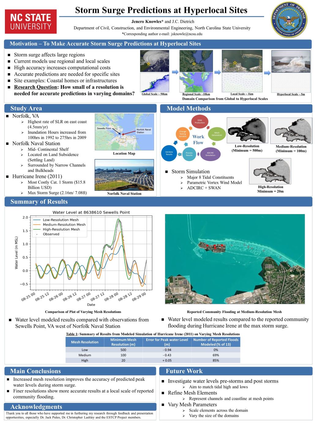
Storm Surge Predictions at Hyperlocal Sites
TA Cuevas López, BJ Tucker, JC Dietrich. “Toward Prediction of High-resolution Maps of Hurricane-driven Coastal Flooding using Deep Learning“. Environmental, Water Resources, and Coastal Engineering Research Symposium, North Carolina State University, 10 March 2023.
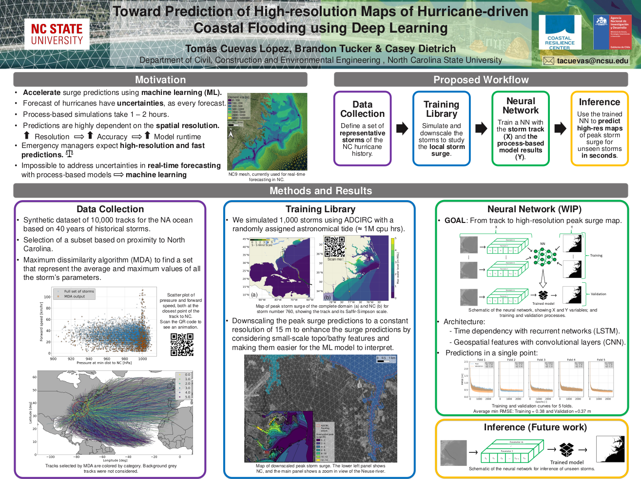
Toward Prediction of High-resolution Maps of Hurricane-driven Coastal Flooding using Deep Learning
Webinar: ADCIRC Coordination
News: Preparing for a Changing Climate
2023/01/11 – UDaily, University of Delaware
UD civil engineers lead research to examine models for coastal readiness at U.S. military bases
UD civil engineers lead research to examine models for coastal readiness at U.S. military bases
![]()
University of Delaware civil engineers are leading a multi-institutional effort to identify the best models to calculate flood risk at coastal military installations where climate change threatens to increase the risk of flood damage from sea level rise and storm surge.
The four-year project, which launched in mid-2022 and will run through spring 2025, is funded by a $2.2 million grant from the U.S. Department of Defense (DoD). Project partners include faculty and students from the Netherlands, North Carolina State University, the University of South Alabama, Texas A&M and the United States Geological Survey (USGS).
…
“The goal is to provide guidance to the DoD about the strengths and weaknesses of each model in comparison. They’re all going to have things they’re good with and things they struggle with,” Dietrich said. Those comparisons will help the agencies decide what types of models they want to use to get what types of information — depending on how much time, effort and funding they want to commit.
There’s also a goal of reducing cost and building smarter models, he said.
“If we are able to improve our predictions at very specific sites along the coast, we also can have better predictions at other specific sites along the coast, like someone’s house or a bridge or other infrastructure,” Dietrich said.
Conference: YCSECA 2022
Conference: ASBPA Coastal Conference 2022
Emulator for Eroded Beach and Dune Profiles due to Storms
 Dunes and beaches are vulnerable to erosion during storm events. Numerical models can predict beach response to storms with fidelity, but their computational costs, the domain-specific knowledge necessary to use them, and the wide range of potential future storm and beach conditions can hinder their use in forecasting storm erosion for short- and long-term horizons. We develop an emulator, which is an efficient predictive model that behaves like a numerical model, to predict the morphologic response of the subaerial beach to storms. Specific emphasis is placed on providing antecedent beach states as an input to the emulator and predicting the post-storm profile shape. Training data include beach profiles at multiple stages in a nourishment life cycle to assess if such a framework can be applied in locations that nourish as a coastal defense policy. Development and application of the emulator is focused on Nags Head, North Carolina, which nourishes its beaches to mitigate hazards of storm waves, flooding, and erosion. A high-fidelity, process-based morphodynamic model is used to train the emulator with 1250 scenarios of sea-storms and beach profiles. The post-storm beach state is emulated with a parameterized power-law function fit to the eroded portion of the subaerial profile. When the emulator was tested for a sequence of real storms from 2019, the eroded beach profiles were predicted with a skill score of 0.66. This emulator is promising for future efforts to predict storm-induced beach erosion in hazard warnings or adaptation studies.