Storm-driven flooding is a severe hazard for coastal communities and regions. Computational models can predict the combined effects of tides, winds, and flooding due to tropical cyclones, including in real-time, but requirements for the models’ runtime make it challenging to consider simulations of the full range of storm uncertainty. To address this problem, researchers have developed neural networks, trained on libraries of storm surge simulations, to predict ensembles of coastal flooding in seconds. However, existing neural networks do not consider the interaction between storm surge and astronomical tides nor storms of any duration. Moreover, they are trained on datasets tailored to represent only extreme conditions. We aim to develop a neural network to predict the peak total water levels for any storm at specific locations along the North Carolina coast.
 In this research, we implemented a neural network to predict peak values for total water level (tides and storm surge) at multiple stations, considering astronomical tides and storm tracks of any duration as inputs. To create the training library, we simulated 1,813 synthetic tropical cyclones based on historical data in the North Atlantic Ocean, with a specific focus on storms that affect North Carolina. These simulations used a full-physics hydrodynamic model with variable spatial resolution of about 50 m near the coast. The outputs were downscaled to grayscale images with a higher and constant resolution of 15 m, enhancing the flood predictions by considering small-scale topographic features, and then used as training data for the neural network. The many-to-one deep learning model predicts a single peak total water level in time at multiple locations in space using time series of the offshore astronomical tide and track parameters as inputs. We used the model to make probabilistic predictions of peak total water levels for observed and perturbed tracks of several historical storms that affected North Carolina.
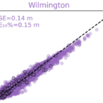 We showed that the neural network performed well (with errors ranging from 8 to 43 cm) in predicting peak total water levels at nine locations in North Carolina. We applied the neural network to make probabilistic predictions of peak total water levels for observed and perturbed tracks of historical storms. For each storm, the neural network predicted at nine stations for 101 storm scenarios (the true/historical storm and 100 perturbations) in less than 10 seconds. The performance for the observed historical storms was similar to those obtained in process-based simulations, but with a significant gain in computational runtime.
TA Cuevas López (2024). “Prediction of Peak Water Levels during Tropical Cyclones with Deep Learning,” North Carolina State University.


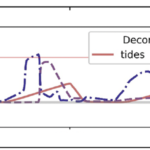 With sea-level rise, flooding in coastal communities is now common during the highest high tides. Floods also occur at normal tidal levels when rainfall overcomes stormwater infrastructure that is partially submerged by tides. Data describing this type of compound flooding is scarce and, therefore, it is unclear how often these floods occur and the extent to which non-tidal factors contribute to flooding. We combine measurements of flooding on roads and within storm drains with a numerical model to examine processes that contribute to flooding in Carolina Beach, NC, USA — a community that chronically floods outside of extreme storms despite flood mitigation infrastructure to combat tidal flooding. Of the 43 non-storm floods we measured during a year-long study period, one-third were unexpected based on the tidal threshold used by the community for flood monitoring. We introduce a novel model coupling between an ocean-scale hydrodynamic model (ADCIRC) and a community-scale surface water and pipe flow model (3Di) to quantify contributions from multiple flood drivers. Accounting for the compounding effects of tides, wind, and rain increases flood water levels by up to 0.4 m compared to simulations that include only tides. Setup from sustained (non-storm) regional winds causes deeper, longer, more extensive flooding during the highest high tides and can cause floods on days when flooding would not have occurred due to tides alone. Rainfall also contributes to unexpected floods; because tides submerge stormwater outfalls on a daily basis, even minor rainstorms lead to flooding as runoff has nowhere to drain. As a particularly low-lying coastal community, Carolina Beach provides a glimpse into future challenges that coastal communities worldwide will face in predicting, preparing for, and adapting to increasingly frequent flooding from compounding tidal and non-tidal drivers atop sea-level rise.