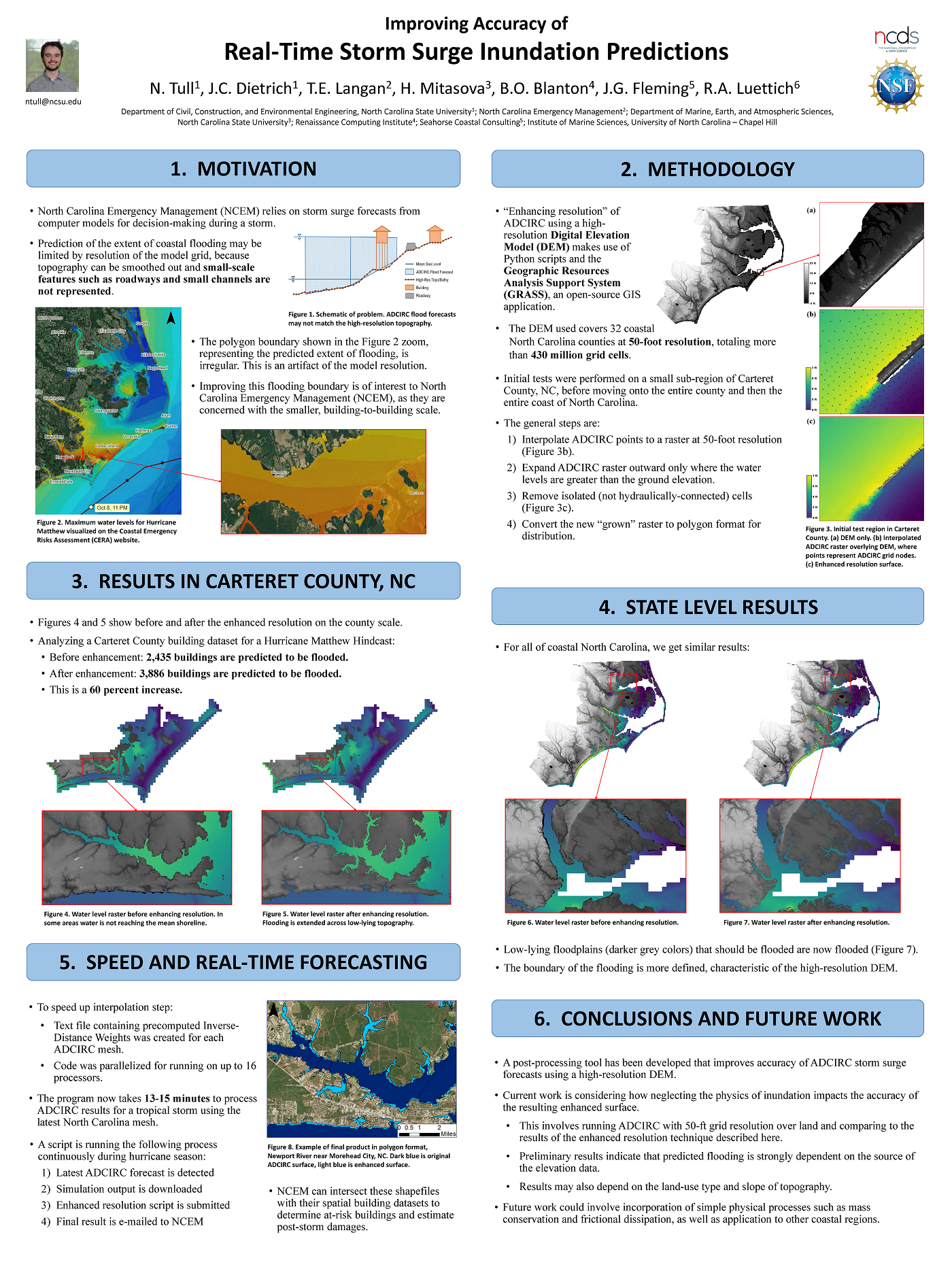
An Earth’s Future Special Collection: Impacts of the coastal dynamics of sea level rise on low-gradient coastal landscapes

Rising sea level represents a significant threat to coastal communities and ecosystems, including altered habitats and increased vulnerability to coastal storms and recurrent inundation. This threat is exemplified in the northern Gulf of Mexico, where low topography, marshes, and a prevalence of tropical storms have resulted in extensive coastal impacts. The ability to facilitate adaptation and mitigation measures relies, in part, on the development of robust predictive capabilities that incorporate complex biological processes with physical dynamics. Initiated in 2010, the 6-year Ecological Effects of Sea Level Rise—Northern Gulf of Mexico project applied a transdisciplinary science approach to develop a suite of integrated modeling platforms informed by empirical data that are capable of evaluating a range of climate change scenarios. This special issue highlights resultant integrated models focused on tidal hydrodynamics, shoreline morphology, oyster ecology, coastal wetland vulnerability, and storm surges that demonstrate the need for dynamic models to incorporate feedbacks among physical and biological processes in assessments of sea level rise effects on coastal systems. Effects are projected to be significant, spatially variable and nonlinear relative to sea level rise rates. Scenarios of higher sea level rise rates are projected to exceed thresholds of wetland sustainability, and many regions will experience enhanced storm surges. Influenced by an extensive collaborative stakeholder engagement process, these assessments on the coastal dynamics of sea level rise provide a strong foundation for resilience measures in the northern Gulf of Mexico and a transferable approach for application to other coastal regions throughout the world.

DM Kidwell, JC Dietrich, SC Hagen, SC Medeiros (2017). “An Earth’s Future Special Collection: Impacts of the coastal dynamics of sea level rise on low-gradient coastal landscapes.Earth’s Future, 5(1), 2-9, DOI: 10.1002/2016EF000493.

Conference: NCBIWA 2016

How to Run Kalpana

Kalpana converts ADCIRC output files in netCDF format to Google Earth (kmz) or GIS shapefiles for use with conventional GIS software. The latest version of the code is maintained at our GitHub repository: https://github.com/ccht-ncsu/Kalpana.

Command line arguments control the way it produces output, including the number of contour levels, their values, and the color scale. When these specifications are absent from the command line, it uses reasonable default settings so in many cases only a few of the available command line options will be used for any particular plot.

Visualization of Maximum Water Levels along the North Carolina coast during Hurricane Arthur (2014) using polygon shapefiles created by Kalpana with ArcGIS satellite imagery.

Visualization of Maximum Water Levels along the North Carolina coast during Hurricane Arthur (2014) using polygon shapefiles created by Kalpana with ArcGIS satellite imagery.

Continue reading

Installing Python Modules for Kalpana

This post was contributed by CCHT collaborator Jason Fleming. This is a LONG post, but as he notes, it is a stream of consciousness about how he compiled the modules needed by Kalpana. Hopefully his experience will be helpful to new users. After the modules have been compiled, then Kalpana is very easy to use. So please don’t be discouraged!

The actual script kalapana.py does not require installation, it is merely executed. However, it relies on several Python modules that most users (or their IT supporters) will need to install before working with Kalpana. These modules are:

  • matplotlib – main python module used for data visualization.
  • pylab – Imports plotting and numerics libraries in a single name space.
  • shapely – used to construct geometric objects like Points, Polygons and LineStrings.
  • fiona – for writing .shp files.
  • netCDF4 – reading and writing netCDF files.
  • datetime – dates and time calculation, manipulation, and formatting.
  • time – contains time related functions for measuring the performance of the code itself.
  • numpy – to facilitate scientific computing; used primarily in Kalpana for working with n-dimensional numpy arrays, which are ideal for storing large amounts of data.
  • collections – accessing OrderedDict, which is a dictionary subclass that remembers the order in which entries were added, whereas an ordinary dictionary does not do so).
  • simplekml – writing kml (Google Earth) files.

In the process of installing Python modules on a desktop platform, as well as an HPC platform, I’ve found that the process can be very challenging. The biggest issue is conflicting module version dependencies, which can be handled by the use of virtual execution environments for Python (explained below).

Continue reading