

fort.26 file for SWAN v41.31 to remove erroneous WCAP input.Updated 2021/12/13: Adding example files for SWAN v41.31 with ST6 physics.
Updated 2016/09/18: Adding example files for use with older versions of SWAN.
Many new users of SWAN+ADCIRC, after reading the instructions on how to compile and run the coupled models, have asked for example input files to test their implementation. While we have posted an example application of Hurricane Gustav (2008), that example will require a small parallel cluster to run efficiently. There is a need for a smaller example that can be run in serial.
This example is much smaller, and it includes coverage of the Albemarle-Pamlico Estuarine System (APES) along the North Carolina coastline. The mesh has only 1,069 vertices, and thus it can be run in serial in less than 10 min. The example is a hindcast of Hurricane Irene (2011), which moved over this system and caused waves and surge inside the shallow sounds and estuaries.
The entire set of example input files is: Irene-APES-v41.31.zip
- For versions before SWAN 41.31 and ADCIRC 55.00, please use: Irene-APES-v41.10.zip.
- For versions before SWAN 41.10 and ADCIRC 53.00, please use: Irene-APES-Old.zip.
The individual files are described below. They have been modified to be compatible with the latest versions of the codes, and to reflect our latest settings for SWAN and ADCIRC. These files are extremely coarse, both in the mesh resolution and the wind field, but they are a good starting point for new users of the coupled models.

Contours and vectors of wind velocities (m/s) during Hurricane Irene (2011) in the Albemarle-Pamlico Estuarine System.
Unstructured Mesh:
The unstructured mesh is fort.14. The APES mesh contains 1,069 vertices and 1,737 triangular elements. It was created by coarsening the APES example on the ADCIRC web site. It includes the Albemarle and Pamlico sounds and estuaries, but at extremely low resolution, and it does not contain any floodplains. It also does not contain any open inlets to the Atlantic Ocean.
Vertex-Based Attributes:
The attributes file is fort.13. In this attributes file, vertex-based information (other than bathymetry) can be specified to vary spatially over the mesh. This example contains four attributes:
- The sea surface height above the geoid is set to a constant 0.0 m; this setting does not change the model’s assumed datum of mean sea level.
- The primitive weighting in the GWCE is set to 0.03.
- The Manning’s n values are set to 0.012.
- The horizontal eddy viscosity is set to 4.0.
All of these values are constant in space and time. While the fort.13 file can be used to assign attributes that are spatially-varying, this capability is not exercised in this example.
ADCIRC Control File:
The control file is fort.15. This control file contains the run-time parameters for ADCIRC, including the time step, duration, output file specifications, etc. This Irene simulation is set to run for a total of 3.0 days, including a 1-day ramp. This file does not contain any tidal forcing, because this small mesh does not contain any open boundaries to the Atlantic Ocean.
Best-Track for Irene:
The wind file is bal092011.dat, which ADCIRC expects to be named as fort.22. The best-track files contain information about the location of the eye, the central pressure, the radii to maximum winds, etc. ADCIRC uses this information to construct internally the pressure and wind fields.
In this example, the best-track file was converted for use with the Generalized Asymmetric Holland Model (GAHM) built inside ADCIRC. This capability is enabled by setting NWS=20 in the ADCIRC control file. To convert the best-track file, use the aswip utility with the following commands:
./aswip -n 20 -m 4 -z 2
as described on the ADCIRC web site. The Irene best-track file was also modified to start on 2011/08/25/1200 UTC, to correspond with the start of our simulation.
SWAN Control and Initialization Files:
The control file is fort.26. SWAN also requires an initialization file called swaninit. The initialization file is read first by SWAN; for more information, please see the trouble-shooting page.
This control file contains the commands to couple winds, water levels, currents and bottom friction to ADCIRC. Many of these commands are described elsewhere on this site. Note that the ADCIRC Manning’s n values are converted to roughness lengths and passed to SWAN.
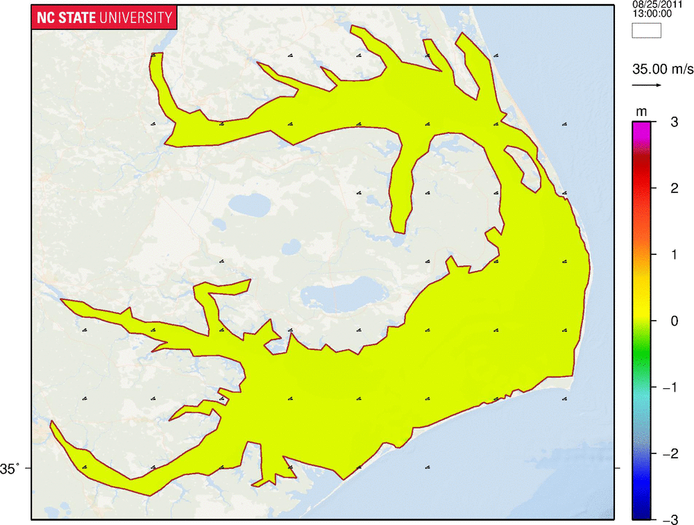
Contours of significant wave heights (m) and vectors of wind velocities (m/s) during Hurricane Irene (2011) in the Albemarle-Pamlico Estuarine System.
The eye of the storm moved over the Albemarle and Pamlico sounds and estuaries, and its strong winds caused waves and surge within these shallow water bodies. Early in the storm, the easterly winds push waves and surge toward the west, where they move into the estuaries. Then, as the storm passes and the winds change to westerly, the waves and surge are pushed eastward to the sound-side of the barrier islands.
Because of the coarse resolution of the APES mesh, especially with respect to hurricane applications, this example problem is efficient. A serial simulation on the Henry2 system at NCSU required about 3 minutes per day of simulation. Computational performance will be a function of the system, however.
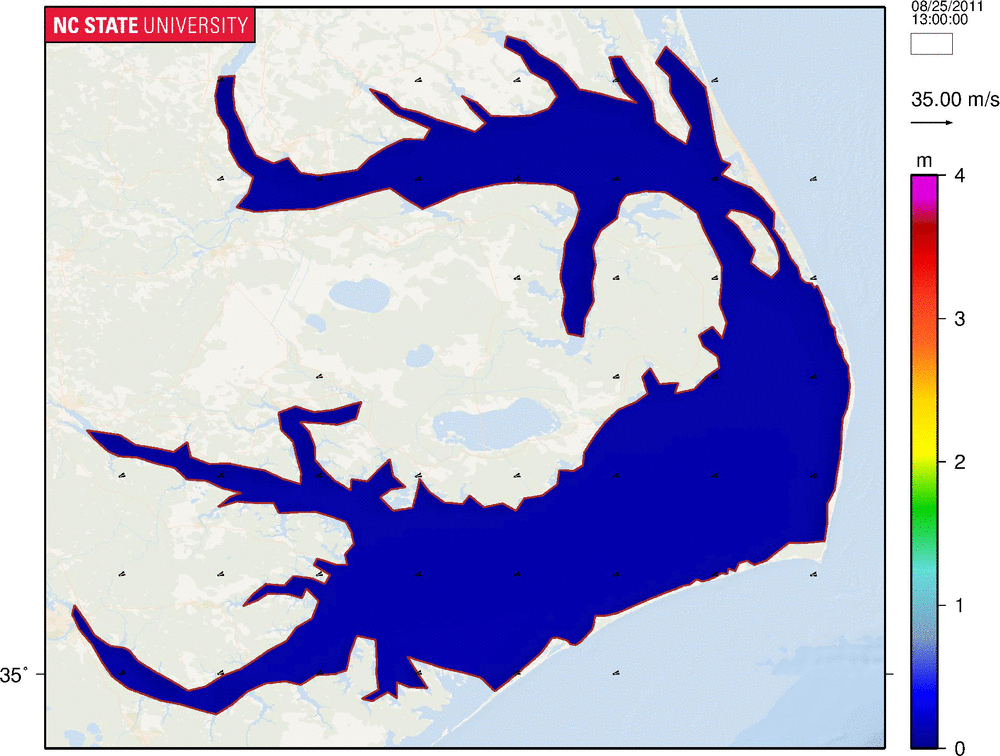
The computed solution is reasonable. The significant wave heights are shown above, while the water levels are shown below. Maximum wave heights of about 3.5 m are observed in the deeper parts of the sounds. Water levels of almost 4 m are observed in the estuaries.
The APES mesh does not resolve the floodplains of coastal North Carolina, however, and thus the computed surge is not reliable. There is no way for the surge to be released from the sounds and into the floodplains. The lack of inlets to the Atlantic Ocean is another drawback, because it prevents surge from flowing into the eastern part of the domain. The drawdown and drying near the barrier islands is exaggerated in this simulation.
Despite the limited accuracy of this example problem, it is nonetheless a useful tool for testing the implementation of SWAN+ADCIRC. It shows how the input files can be established for a simulation with the coupled models, and it is small enough to be run quickly on a single computational core.
Contours of water levels (m) and vectors of wind velocities (m/s) during Hurricane Irene (2011) in the Albemarle-Pamlico Estuarine System.