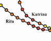
Coastal Louisiana and Mississippi are especially prone to large hurricanes due to their geographic location in the north-central Gulf of Mexico. Several recent hurricanes have devastated the region, creating complicated environments of waves and storm surge. Katrina (2005) and Gustav (2008) made landfall in southeastern Louisiana, and their counter-clockwise winds pushed surge onto the Louisiana-Mississippi continental shelf, into the low-lying wetlands surrounding the Mississippi River, and over and through the levee system that protects metropolitan New Orleans. Rita (2005) and Ike (2008) passed farther to the west, moved across the Texas-Louisiana continental shelf, and created surge that flooded large portions of southwestern Louisiana.
These hurricanes demand detailed hindcasts that depict the evolution of waves and surge during these storm events. These hindcasts can be used to map the likely floodplains for insurance purposes, to understand how the current protection system responded during each storm, and to design a new protection system that will resist better the waves and surge. In addition, the resulting computational model can be used to forecast the system’s response to future storm events.
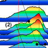
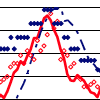
The work described herein represents a significant step forward in the modeling of hurricane waves and surge in complicated nearshore environments. The system is resolved with unprecedented levels of detail, including mesh sizes of 1km on the continental shelf, less than 200m in the wave breaking zones and inland, and down to 20-30m in the fine-scale rivers and channels. The resulting hindcasts are incredibly accurate, with close matches between the modeled results and the measured high-water marks and hydrograph data. They can be trusted to provide a faithful representation of the evolution of waves and surge during all four hurricanes.
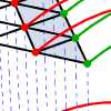
This work also describes advancements in the coupling of wave and surge models. This coupling has been implemented typically with heterogeneous meshes, which is disadvantageous because it requires intra-model interpolation at the boundaries of the nested, structured wave meshes and inter-model interpolation between the wave and circulation meshes. The recent introduction of unstructured wave models makes nesting unnecessary. The unstructured-mesh SWAN wave and ADCIRC circulation models are coupled in this work so that they run on the same unstructured mesh. This identical, homogeneous mesh allows the physics of wave-circulation interactions to be resolved correctly in both models. The unstructured mesh can be applied on a large domain to follow seamlessly all energy from deep to shallow water. There is no nesting or overlapping of structured wave meshes, and there is no inter-model interpolation. Variables and forces reside at identical, vertex-based locations. Information can be passed without interpolation, thus reducing significantly the communication costs.
The coupled SWAN+ADCIRC model is highly scalable and integrates seamlessly the physics and numerics from deep ocean to shelf to floodplain. Waves, water levels and currents are allowed to interact in complex problems and in a way that is accurate and efficient to thousands of computational cores. The coupled model is validated against extensive measurements of waves and surge during the four recent Gulf hurricanes. Furthermore, the coupling paradigm employed by SWAN+ADCIRC does not interfere with the already-excellent scalability of the component models, and the coupled model maintains its scalability to 7,168 computational cores. SWAN+ADCIRC is well-suited for the simulation of hurricane waves and surge.
JC Dietrich (2010). “Development and Application of Coupled Hurricane Wave and Surge Models for Southern Louisiana,” University of Notre Dame.


 Coupling wave and circulation models is vital in order to define shelf, nearshore and inland hydrodynamics during a hurricane. The intricacies of the inland floodplain domain, level of required mesh resolution and physics make these complex computations very cycle-intensive. Nonetheless, fast wall-clock times are important, especially when forecasting an incoming hurricane.
 After the destruction of the Deepwater Horizon drilling platform during the spring of 2010, the northern Gulf of Mexico was threatened by an oil spill from the Macondo well. Emergency responders were concerned about oil transport in the nearshore, where it threatened immediately the fishing waters and coastline from Louisiana to Florida. In this region, oil movement was influenced by a continental shelf with varying width, the protruding Mississippi River delta, the marshes and bayou of southern Louisiana, and the shallow sounds and barrier islands that protect the coastline. Transport forecasts require physics-based computational models and high-resolution meshes that represent the circulation in deep water, on the continental shelf, and within the complex nearshore environment.
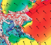 Hurricane Gustav (2008) made landfall in southern Louisiana on 1 September 2008 with its eye never closer than 75 km to New Orleans, but its waves and storm surge threatened to flood the city. Easterly tropical-storm-strength winds impacted the region east of the Mississippi River for 12-15 h, allowing for early surge to develop up to 3.5 m there and enter the river and the city’s navigation canals. During landfall, winds shifted from easterly to southerly, resulting in late surge development and propagation over more than 70 km of marshes on the river’s west bank, over more than 40 km of Caernarvon marsh on the east bank, and into Lake Pontchartrain to the north. Wind waves with estimated significant heights of 15 m developed in the deep Gulf of Mexico but were reduced in size once they reached the continental shelf. The barrier islands further dissipated the waves, and locally generated seas existed behind these effective breaking zones.
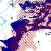
 A large, unpredicted, water level increase appeared along a substantial section of the western Louisiana and northern Texas (LATEX) coasts 12-24 hrs in advance of the landfall of Hurricane Ike (2008), with water levels in some areas reaching 3m above mean sea level. During this time the cyclonic wind field was largely shore parallel throughout the region. A similar early water level rise was reported for both the 1900 and the 1915 Galveston Hurricanes. The Ike forerunner anomaly occurred over a much larger area and prior to the primary coastal surge which was driven by onshore directed winds to the right of the storm track. We diagnose the forerunner surge as being generated by Ekman setup on the wide and shallow LATEX shelf. The longer forerunner time scale additionally served to increase water levels significantly in narrow-entranced coastal bays. The forerunner surge generated a freely propagating continental shelf wave with greater than 1.4m peak elevation that travelled coherently along the coast to Southern Texas, and was 300km in advance of the storm track at the time of landfall. This was, at some locations, the largest water level increase seen throughout the storm, and appears to be the largest freely-propagating shelf wave ever reported. Ekman setup-driven forerunners will be most significant on wide, shallow shelves subject to large wind fields, and need to be considered for planning and forecasting in these cases.
 The unstructured-mesh SWAN spectral wave model and the ADCIRC shallow-water circulation model have been integrated into a tightly-coupled SWAN+ADCIRC model. The model components are applied to an identical, unstructured mesh; share parallel computing infrastructure; and run sequentially in time. Wind speeds, water levels, currents and radiation stress gradients are vertex-based, and therefore can be passed through memory or cache to each model component. Parallel simulations based on domain decomposition utilize identical sub-meshes, and the communication is highly localized. Inter-model communication is intra-core, while intra-model communication is inter-core but is local and efficient because it is solely on adjacent sub-mesh edges. The resulting integrated SWAN+ADCIRC system is highly scalable and allows for localized increases in resolution without the complexity or cost of nested meshes or global interpolation between heterogeneous meshes. Hurricane waves and storm surge are validated for Hurricanes Katrina and Rita, demonstrating the importance of inclusion of the wave-circulation interactions, and efficient performance is demonstrated to 3062 computational cores.
 Few wave measurements have been made in wetlands during high-energy, surge events, such as hurricanes. During Hurricane Gustav in 2008, many nearshore wave measurements were made in Southeastern Louisiana. These data are used to verify a nearshore wave modeling system and to explore the characteristics of hurricane waves in wetlands. The modeling system consists of the wave generation model WAM, the nearhsore wave model STWAVE, and the circulation model ADCIRC. The measurements confirm reasonable success in modeling the waves. The measurements and modeling also expose some of the problems of measuring waves in highly-variable water depths under hurricane forcing and modeling waves in rapidly degrading wetlands.
 Hurricanes Katrina and Rita were powerful storms that impacted southern Louisiana and Mississippi during the 2005 hurricane season. In Part I, the authors describe and validate a high-resolution coupled riverine flow, tide, wind, wave, and storm surge model for this region. Herein, the model is used to examine the evolution of these hurricanes in more detail. Synoptic histories show how storm tracks, winds, and waves interacted with the topography, the protruding Mississippi River delta, east-west shorelines, man-made structures, and low-lying marshes to develop and propagate storm surge. Perturbations of the model, in which the waves were not included, show the proportional importance of the wave radiation stress gradient induced setup.