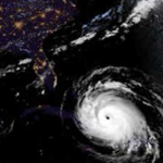
In 2017, Hurricanes Harvey, Irma, and Maria caused more than $200 billion dollars of damage in the United States, as well as the incalculable cost of the loss of life and mental trauma associated with these disasters. In a changing climate, sea level rise and the potential for increasing tropical cyclone intensity can result in even more devastating damages. Therefore, engineers, community planners, and coastal residents need accurate, timely, and accessible forecasting of storm processes and their impact on coastal communities to bolster national resilience and reduce risk to life and property during these events. However, along with uncertainties in understanding and modeling of storm processes, there are complex challenges associated with determining and meeting the needs of end users who rely on these forecasts for emergency management decisions.
To determine needed advancements in storm forecasting, the U.S. Coastal Research Program (USCRP) hosted a Storm Processes and Impacts workshop for coastal stakeholders 16-18 April 2018, in St. Petersburg, Florida. The attendees included local coastal managers, emergency managers, state and regional agencies, federal agency scientists and engineers, academics, and private industry scientists and engineers. Workshop objectives were to synthesize present capabilities for modeling storm processes and forecasting impacts and to prioritize advancements. In addition, the workshop provided an opportunity to bridge the apparent gap between the research of coastal scientists and engineers and the information being distributed publicly and to emergency managers before, during, and after storm events.
N Elko, JC Dietrich, M Cialone, H Stockdon, MV Bilskie, B Boyd, B Charbonneau, D Cox, KM Dresback, S Elgar, A Lewis, P Limber, J Long, TC Massey, T Mayo, K McIntosh, N Nadal-Caraballo, B Raubenheimer, T Tomiczek, A Wargula (2019). “Advancing the Understanding of Storm Processes and Impacts.” Shore & Beach, 87(1), 41-55.


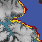
 Barrier islands are susceptible to erosion, overwash, and breaching during intense storms. However, these processes are not represented typically in large-domain models for storm surge and coastal inundation. In this study, we explore the requirements for bridging the gap between dune-scale morphodynamic and region-scale flooding models. A high-resolution XBeach model is developed to represent the morphodynamics during Hurricane Isabel (2003) in the North Carolina (NC) Outer Banks. The model domain is extended to more than 30 km of Hatteras Island and is thus larger than in previous studies. The predicted dune erosion is in good agreement with post-storm observed topography, and an ‘‘excellent’’ Skill Score of 0.59 is obtained on this large domain. Sensitivity studies show the morphodynamic model accuracy is decreased as the mesh spacing is coarsened in the cross-shore direction, but the results are less sensitive to the alongshore resolution. A new metric to assess model skill, Water Overpassing Area (WOA), is introduced to account for the available flow pathway over the dune crest. Together, these findings allow for upscaled parameterizations of erosion in larger-domain models. The updated topography, obtained from XBeach prediction, is applied in a region-scale flooding model, thus allowing for enhanced flooding predictions in communities along the Outer Banks. It is found that, even using a fixed topography in region-scale model, the flooding predictions are improved significantly when post-storm topography from XBeach is implemented. These findings can be generalized to similar barrier island systems, which are common along the U.S. Gulf and Atlantic coasts.
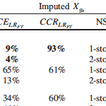 Missing building attributes are problematic for development of data-based fragility models. Relative to other disciplines, the application of imputation techniques is limited in the field of engineering. Current imputation techniques to replace missing building attributes lack evaluations of imputation model performance, which ensure accuracy and validity of the imputed data. This paper presents two imputation approaches, along with imputation diagnostic and comparison approaches, for binary building attribute data with missing observations. Predictive mean matching (PMM) and multiple imputation (MI) are used to impute foundation type and number of stories attributes. The diagnostic approach, based on the logistic regression goodness-of-fit test, is used to evaluate the imputation model fit. The comparison approach, based on the percentage of correctly imputed observations, is used to evaluate the imputation model performance. A data set of single-family homes damaged by the 2005 Hurricane Katrina is used to demonstrate implementation of the methodology. Based on the comparison approach, PMM models showed 9% and 2% greater accuracy than MI models in imputing foundation type and number of stories, respectively.
 During major storm events such as hurricanes, emergency managers rely on fast and accurate forecasting models to make important decisions concerning public safety. These models can be computationally costly and cannot quickly make predictions at the highest geospatial resolution. However, model output can be post-processed to mimic high-resolution results with minimal additional computational cost. This research proposes methods for improvement in the accuracy of downscaling (enhancing the resolution of) a real-time storm surge forecasting model. Such improvements to downscaling methods include 1) expansion in its spatial applicability, 2) adding physics using water surface slopes, and 3) adding physics using friction losses across the ground surface.
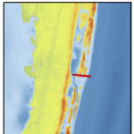
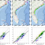
 The downscaling process is also improved by adding physics using the slopes method and the head loss method. The slopes method incorporates the slopes of the water levels produced by ADCIRC, rather than only the value of the water level. By interpolating ADCIRC output water elevation points into a smooth surface, slopes of this surface can be used to influence the elevations of downscaled water levels. The head loss method adds friction loss due to variations in the ground surface based on land cover types and friction associated with each type. As water travels over any surface, head loss, or a loss in energy, occurs at different rates depending on the surface roughness. This rudimentary hydrologic principle is applied to increase the accuracy of the downscaling process at minimal cost. The downscaling methods are applied for results from an ADCIRC simulation used in real-time forecasting, and then compared with results from an ADCIRC simulation with 10 times more resolution in Carteret County, NC. The static method tends to over-estimate the flood extents, and the slopes method is similar. However, the head loss method generates a downscaled flooding extent that is a close match to the predictions from the higher-resolution, full-physics model.
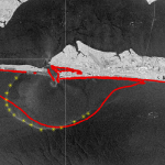 Multiple river-dominated estuaries line the northern Gulf coast and introduce substantial density variations. Their plumes have been shown to be highly sensitive to wind and tide effects, but in studies with limited observations and idealized wind forcing. This study explores these effects with a dynamic model that can represent the full behavior from river through estuary to shelf, and for a period with extensive observations. The inner shelf adjacent to Choctawhatchee Bay, a micro tidal estuary situated along the Florida Panhandle, is subject to buoyant, brackish outflows during the ebb-phase of the tidal cycle.
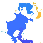
 Averaging techniques are used to generate upscaled forms of the shallow water equations for storm surge including subgrid corrections. These systems are structurally similar to the standard shallow water equations but have additional terms related to integral properties of the fine-scale bathymetry, topography, and flow. As the system only operates with coarse-scale variables (such as averaged fluid velocity) relating to flow, these fine-scale integrals require closures to relate them to the coarsened variables. Closures with different levels of complexity are identified and tested for accuracy against high resolution solutions of the standard shallow water equations. Results show that, for coarse grids in complex geometries, inclusion of subgrid closure terms greatly improves model accuracy when compared to standard solutions, and will thereby enable new classes of storm surge models.
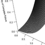 Multi-hazard hurricane data-based fragility models are able to represent multiple predictor variables, be validated based on observed data, and consider variability in building characteristics and hazard variables. This paper develops predictive hurricane, multi-hazard, single-family building fragility models for ordered categorical damage states (DS) and binary complete failure/non-complete failure using proportional odds cumulative logit and logistic regression models, respectively. In addition to their simplicity, these models are able to represent multiple hurricane hazard variables and include variable interactions, thus improving model fitting and damage prediction. Surveys of physical damage in coastal Mississippi following Hurricane Katrina (2005) and high-resolution numerical hindcast hazard intensities from the Simulating WAves Nearshore and ADvanced CIRCulation (SWAN + ADCIRC) models are used as model input. Prediction accuracy is expressed in terms of cross-validation (CV) and evaluated using leave-one-out cross-validation (LOOCV).
 The amount and extent of coastal flooding caused by hurricanes can be sensitive to the timing or speed of the storm. For storms moving parallel to the coast, the hazards can be stretched over a larger area. Hurricane Matthew was a powerful storm that impacted the southeastern U.S. during October 2016, moving mostly parallel to the coastline from Florida through North Carolina. In this study, three sources for atmospheric forcing are considered for a simulation of Matthew’s water levels, which are validated against extensive observations, and then the storm’s effects are explored on this long coastline. It is hypothesized that the spatial variability of Matthew’s effects on total water levels is partly due to the surge interacting nonlinearly with tides. By changing the time of occurrence of the storm, differences in storm surge are observed in different regions due to the storm coinciding with other periods in the tidal cycles. These differences are found to be as large as 1m and comparable to the tidal amplitude. A change in forward speed of the storm also should alter its associated flooding due to differences in the duration over which the storm impacts the coastal waters. With respect to the forward speed, the present study contributes to established results by considering the scenario of a shore-parallel hurricane. A faster storm caused an increase in peak water levels along the coast but a decrease in the overall volume of inundation. On the other hand, a slower storm pushed more water into the estuaries and bays and flooded a larger section of the coast. Implications for short-term forecasting and long-term design studies for storms moving parallel to long coastlines are discussed herein.