

Category Archives: NCDS Data Fellows 2016-2017
Seminar: UNC Department of Geological Sciences
Webinar: NCDS DataBytes
News: Enhancing Storm Surge Visualization
2017/10/04 – Science Node
The aim of storm surge models: When a storm approaches, emergency managers want fast and accurate forecasts
The aim of storm surge models: When a storm approaches, emergency managers want fast and accurate forecasts
![]()
Although our model provides water level predictions from the deep ocean all the way to the coastal floodplains, the system is limited by the model’s resolution. Topographic features at scales smaller than 500 feet, such as roadways or narrow stream channels, are often not included in the models because of the computer time needed to produce such high-resolution outputs. Because of this limitation, the extent of flooding can be underpredicted by the model.
2017/08/31 – National Consortium for Data Science
Data Fellows project aims to make storm surge predictions faster and more accurate

Continuing our North Carolina Sea Grant project and with new support from the National Consortium of Data Science, we are developing a method to improve prediction of the true flooding extent by combining the results of our model with more accurate elevation datasets.
To perform this prediction of the flooding extent, we use a Geographic Information System (GIS) called GRASS GIS that specializes in processing very large amounts of data. The project has two major objectives. The first is to process the modeled water levels and the elevation data set together, producing a map showing the extent of predicted flooding. When the modeled water levels are greater than the land elevation, flooding extends outward into neighboring, unflooded areas in the data set. By mapping the model results to the higher resolution data sets on elevation, we can create more accurate surge forecasts of overland flooding.
2017/08/08 – NC Sea Grant Coastwatch Currents
Fast, Accurate Forecasts of Coastal Flooding: Enhancing Visualization of Storm Surge Guidance to Support Emergency Managers
 Storm surge models must be both fast and accurate to give coastal communities the guidance they need to prepare for and respond to a storm. Perhaps just as important is the need for these forecasts to be visualized in a way that is meaningful and useable by emergency managers.
ADCIRC forecasts are currently visualized using Kalpana, a Python script that converts the model output into formats compatible with commonly-used visualization applications such as ArcGIS and Google Earth. With support from the National Consortium of Data Science (NCDS) and in partnership with North Carolina Emergency Management (NCEM), our team has developed a new visualization method that makes use of enhanced topographic resolution along the flooding boundary. This results in modeled storm surge extending farther into estuaries and floodplains, increasing the accuracy of the forecast.
Seminar: NWS Raleigh
News: Hurricane Matthew
2016/10/17 – DHS CRCoE
Coastal Resilience Center researchers, partners aid in Hurricane Matthew preparation and recovery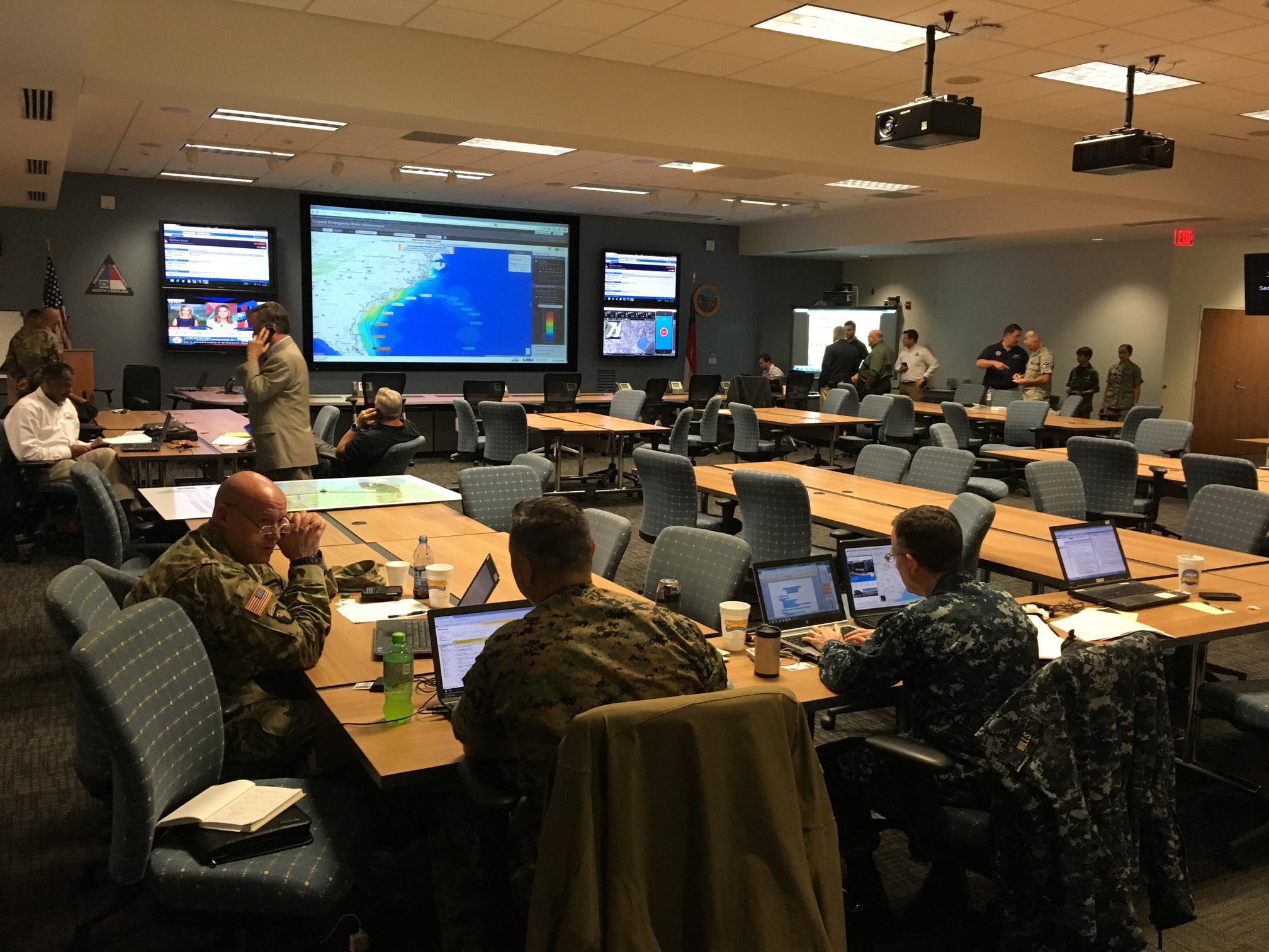
Coastal Resilience Center researchers, partners aid in Hurricane Matthew preparation and recovery
![]()
Dr. Casey Dietrich of NCSU, whose CRC project focuses on improving the speed of ADCIRC modeling, visited the North Carolina Emergency Management (NCEM) State Emergency Operations Center to see NCEM’s operation and workflow during storm response. Dietrich said emergency managers were excited about the data provided by ADCIRC predictions.
“They are using both the CERA site and the shapefiles we are generating,” Dietrich said. “The shapefiles are being combined manually with other datasets to determine the potential flood damages, in terms of both number and cost of buildings and infrastructure.”
Dietrich said that ADCIRC predictions have compared favorably to post-storm high-water marks and U.S. Geological Survey measurements of storm surge.
“Their comparisons after Hermine showed matches within a foot to the peak water levels,” Dietrich said. “They described ADCIRC as their eyes on the coast.”
Dietrich’s work with ADCIRC to provide more accurate storm surge estimates for North Carolina is also partially funded by the North Carolina Sea Grant and the National Consortium for Data Science.
The CERA website is used during Hurricane Matthew preparations at the NCEM Emergency Operations Center.
2016/10/06 – CCEE
Dietrich Aiding Efforts to Forecast Flooding during Hurricane Matthew

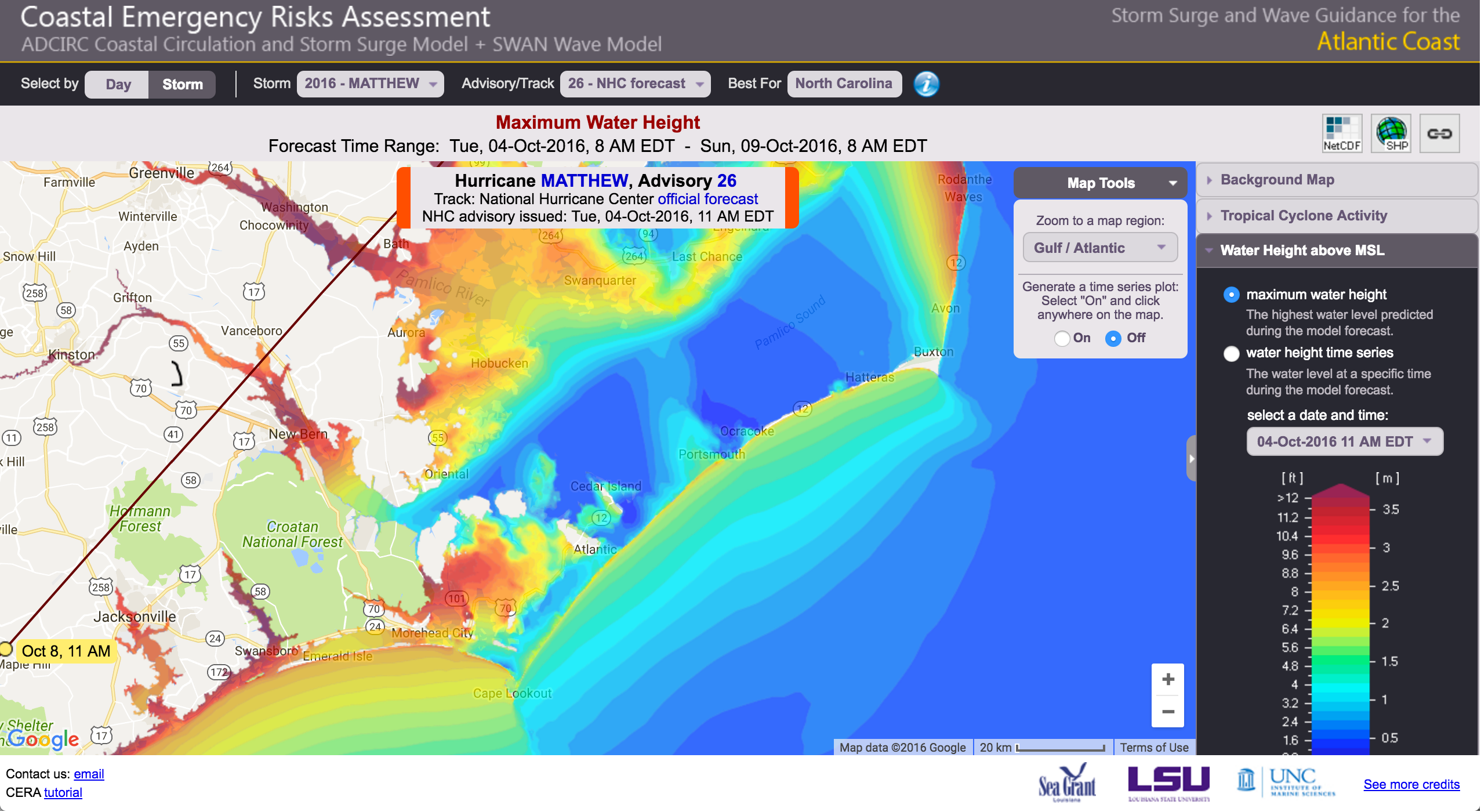
As Hurricane Matthew approaches Florida and prepares to move up the U.S. east coast, researchers in North Carolina are running models to forecast the storm surge and coastal flooding. Dr. Casey Dietrich is working with collaborators at the University of North Carolina, the Renaissance Computing Institute, and Seahorse Coastal Consulting to generate and share guidance during the storm. The models are run every 6 hours, and they provide high-resolution forecasts of possible flooding throughout the NC coast. The forecasts can be found at: http://nc-cera.renci.org/. Dietrich is providing forecast guidance to NC Emergency Management, for use in decisions about evacuation and resource deployment. This real-time forecasting is part of a research project to downscale the model results and provide them in formats tailored to the needs of emergency managers.
Forecast of coastal flooding due to Hurricane Matthew (2016).
Presentation: NCDS Data Fellows 2016
Mapping and Visualization of Coastal Flood Forecasts for Decision Support
The goal of this proposed research is to enable data-driven decision-making for coastal communities during storm events. The ADCIRC forecast data will be connected to geospatial databases for use by emergency managers to consider inundation and damages during storm scenarios. The critical objectives of this proposed research are (1) downscaling the model forecast data to the resolution of geospatial datasets used for decision support, (2) assessing the implications of this downscaling on forecast accuracy, and (3) connecting these technologies with an end user, specifically the NC Emergency Management.
JC Dietrich. “Mapping and Visualization of Coastal Flood Forecasts for Decision Support.” National Consortium for Data Science, Data Fellows, 2016/07/01 to 2017/06/30, $50,000 (Dietrich: $50,000).