

Category Archives: Models
News: Faster Storm Surge Forecasting
2018/06/12 – DHS Coastal Resilience Center of Excellence
NC State project aims to create faster storm surge forecasting
NC State project aims to create faster storm surge forecasting
![]()
Planning for a hurricane is a complicated process involving many stakeholders and varying degrees of uncertainty. Accurate predictions of storm surge and wave heights are vital to decision-making before, during and after the storm. Creating these predictions through modeling software can be expensive and time-consuming. When dealing with hurricanes, time is critical for emergency managers and other officials.
Helping decision-makers to save valuable prediction time is CRC Principal Investigator Dr. Casey Dietrich of North Carolina State University (NCSU). His project, “Improving the Efficiency of Wave and Surge Models via Adaptive Mesh Resolution,” involves collaboration with co-PI Dr. Clint Dawson at the University of Texas at Austin. Their project focuses on speeding up a widely used prediction tool, ADCIRC. His work with North Carolina Emergency Management during Hurricane Matthew in 2016, and his contributions to developing future disaster resilience specialists, have helped make significant contributions to disaster preparation and recovery.
Improving Accuracy of Real-Time Storm Surge Inundation Predictions
Emergency managers rely on fast and accurate storm surge predictions from numerical models to make decisions and estimate damages during storm events. One of the challenges for such models is providing a high level of resolution along the coast without significantly increasing the computational time. Models with large domains, such as the ADvanced CIRCulation (ADCIRC) model used in this study, are accurate in predicting water levels and their variation in complex coastal regions, however their spatial resolution may limit their predictions of flooding at the scale of buildings, roadways, and critical infrastructure.
A new tool has been developed that uses Geographic Information System (GIS) scripts to enhance the resolution of maximum water level predictions at the boundary of predicted flooding using a high-resolution Digital Elevation Model (DEM). The water levels predicted by the lower resolution model are extrapolated outward to where the water would intersect with the higher resolution elevation dataset. The result is a highly-refined flooding boundary that represents inundation on scales smaller than the typical ADCIRC mesh resolution. This tool can process a 15-m DEM for all 32 coastal counties of the state of North Carolina in less than 15 minutes during a storm event.
Comparison of results using spatial building datasets showed that for a simulation of Hurricane Matthew, 2,353 buildings were predicted to be flooded in Carteret County, NC, prior to enhancing resolution and 3,298 post-enhancement, an increase of 40 percent. In Dare County, the increase was 22 percent. This dramatic increase in flooded buildings shows the importance of achieving high accuracy in floodplains, as a relatively small change in predicted flooding extent can have a substantial impact on the predicted number of flooded buildings. The validity of these results was tested via comparisons to results of an ADCIRC model with the same 15-m resolution as the DEM in Dare County. Dare County is a coastal region with widely-varying topography and land cover, and preliminary comparisons have shown that the GIS method is accurate in coastal regions with steeper slopes and less accurate in flatter, low-lying areas.
Thesis Defense: Nelson Tull
News: Improving Coastal Flooding Predictions
2018/05/14 – NC Sea Grant Coastwatch Currents
Hurricane Hindsight: Researchers Work to Improve Coastal Flooding Predictions
Hurricane Hindsight: Researchers Work to Improve Coastal Flooding Predictions

Computer models can make surge predictions based on limited information about storm characteristics such as track, size, maximum wind speed and central pressure. Those parameters are used to predict the surface pressures and wind speeds throughout a coastal region. Those atmospheric conditions are then used to predict how the ocean will respond by generating large waves and surge, and by flooding into low-lying areas.
Given all the variables involved, there’s a lot of room for error in storm wind and surge prediction modeling.
For our study, we wanted to know how forecasting errors affect subsequent coastal flooding predictions. To that end, we needed to answer a couple of questions: First, as a storm moves closer to the coast, how accurate are forecasts of certain storm parameters like track, size, and maximum wind speed? Second, how do those forecasts affect predictions of wind speeds and storm surge?
Conference: ADCIRC 2018
Poster: Graduate Student Research Symposium 2018
A Thomas, JC Dietrich, JG Fleming, BO Blanton, T Asher, RA Luettich. “High-Resolution Modelling of Surge during Hurricane Matthew (2016).” Graduate Student Research Symposium, North Carolina State University, 21 March 2018.
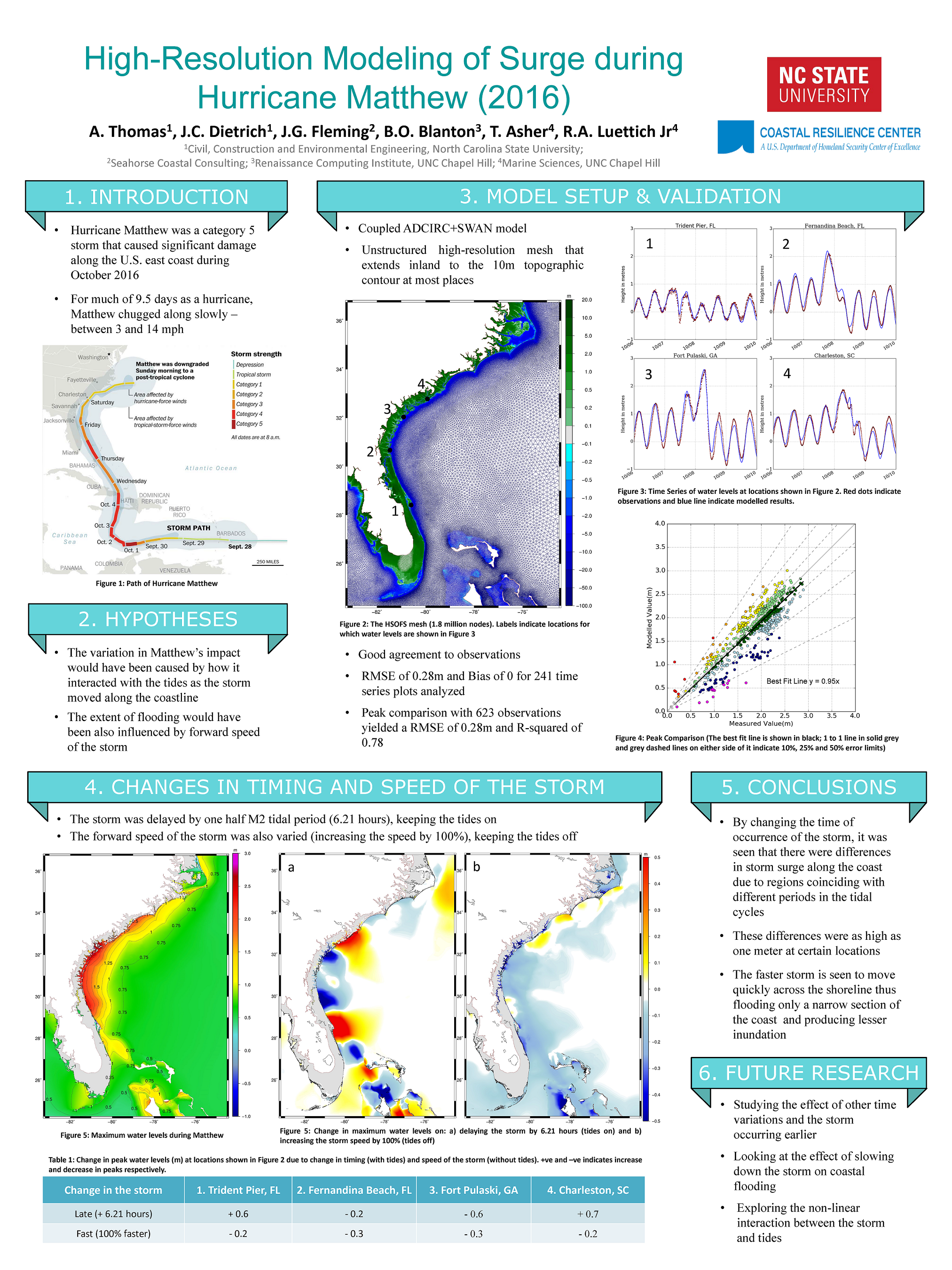
High-Resolution Modelling of Surge during Hurricane Matthew (2016).
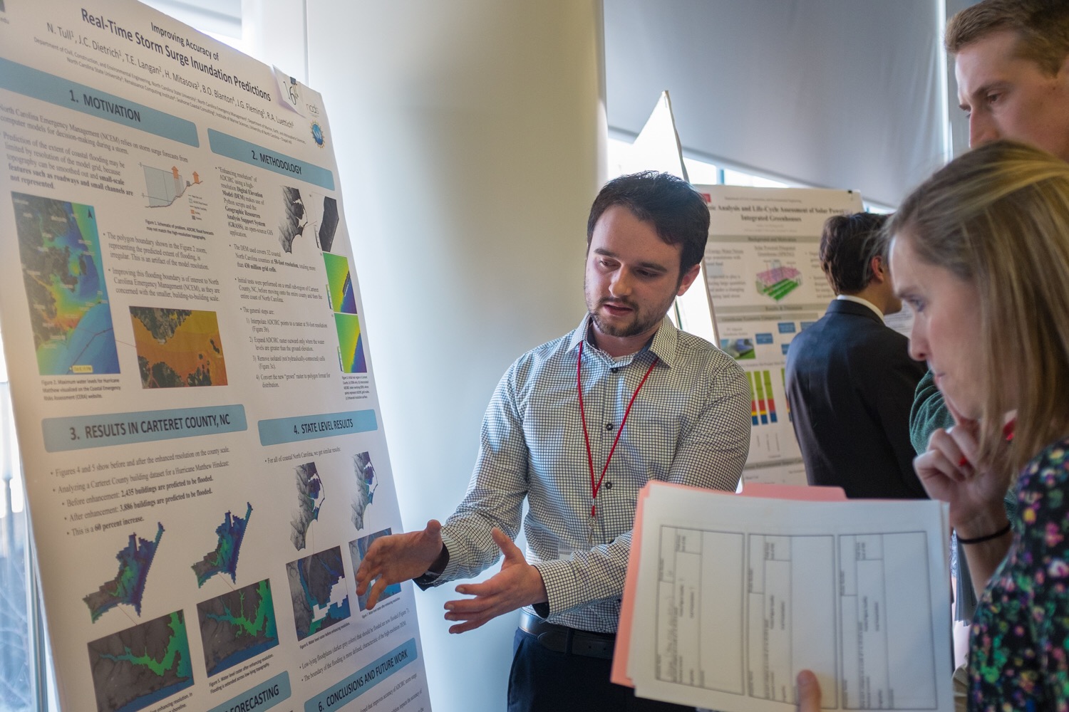
Nelson and Ajimon win Student Poster Awards
MS student Nelson Tull won First Place in the Student Poster Competition at the EWC Research Symposium. Nelson described his research to enhance resolution of coastal flooding forecasts for decision support.
PhD student Ajimon Thomas won Honorable Mention. Ajimon described his research to quantify interactions between tides and storm surge along the U.S. southeast coast during Hurricane Matthew.
This event is an annual showcase for research in our Environmental, Water Resources, and Coastal (EWC) engineering group, as well as a recruiting event for potential students. Awardees are selected by judges from other academic departments, government agencies, and consulting firms. Students presented their posters to judges and visitors during a poster session, and then finalists presented orally to the entire audience.
Congratulations to Nelson and Ajimon!
Nelson Tull shares his poster with judges at the 2018 EWC Research Symposium.