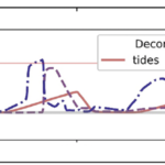
Improved Wave Predictions with ST6 Physics and ADCIRC+SWAN

The Simulating WAves Nearshore (SWAN, Booij et al. 1999) model is used widely for predictions of waves in coastal regions. Like other spectral wave models, SWAN uses parameterizations to represent wave evolution due to sources (e.g. wind), sinks (e.g. whitecapping, bottom friction, depth-limited breaking), and resonance (e.g. quadruplet and triad wave-wave interactions). Each parameterization is based typically on observational data to represent the transfer of energy to, from, and between waves. It is necessary for each term to represent its physical process, but it is also necessary for the terms to be calibrated collectively to represent their combined effects on wave evolution. The calibrated wave predictions can then be coupled with models for circulation and coastal flooding, e.g. ADvanced CIRCulation (ADCIRC, Luettich et al. 1992).

SWAN release version 41.20 included a new “package” of wave physics (referred to as ST6 physics). This package has new parameterizations of wind input, whitecapping, swell dissipation, wind speed scaling, and other processes (Rogers et al. 2012). The ST6 physics have been adopted by other wave models (e.g. NOAA’s WaveWatch III, Liu et al. 2019), and it may become the preferred physics package for SWAN. However, because the ST6 physics package has changes to so many parameterizations, it is necessary to quantify its effects on wave predictions. Recent studies (e.g. Aydogan and Ayat 2021) have demonstrated the benefits of using the ST6 physics in the standalone version of SWAN, but its effects have not been quantified for the coupled ADCIRC+SWAN (Dietrich et al. 2011a), which is used for real-time forecasts during impending storms. Do the ST6 physics improve the ADCIRC+SWAN wave predictions?

CC Day, JC Dietrich (2022). “Improved wave predictions with ST6 Physics and ADCIRC+SWAN.” Shore & Beach, 90(1), 59-61, DOI: 10.34237/1009016.

Ajimon’s Paper Selected as Editor’s Choice

Our recent paper, “Effects of Model Resolution and Coverage on Storm-Driven Coastal Flooding Predictions,” was selected as the Editor’s Choice by the Journal of Waterway, Port, Coastal and Ocean Engineering. The chief editor selects a paper from the current issue. The paper is made free with registration and featured on the journal home page for two months, after which it will continue to be featured in the Editor’s Choice Collection.

Congratulations to Ajimon!

Effects of Model Resolution and Coverage on Storm-Driven Coastal Flooding Predictions

Predictions of storm surge and flooding require models with higher resolution of coastal regions, to describe fine-scale bathymetric and topographic variations, natural and artificial channels, flow features, and barriers. However, models for real-time forecasting often use a lower resolution to improve efficiency. There is a need to understand how resolution of inland regions can translate to predictive accuracy, but previous studies have not considered differences between models that both represent conveyance into floodplains and are intended to be used in real time. In this study, the effects of model resolution and coverage are explored using comparisons between forecast-ready and production-grade models that both represent floodplains along the US southeast coast, but with typical resolutions in coastal regions of 400 and 50 m, respectively. For two storms that impacted the US southeast coast, it is shown that, although the overall error statistics are similar between simulations on the two meshes, the production-grade model allowed a greater conveyance into inland regions, which improved the tide and surge signals in small channels and increased the inundation volumes between 40% and 60%. Its extended coverage also removed water level errors of 20–40 cm associated with boundary effects in smaller regional models.

A Thomas, JC Dietrich, CN Dawson, RA Luettich (2022). “Effects of Model Resolution and Coverage on Storm-Driven Coastal Flooding Predictions.” Journal of Waterway, Port, Coastal, and Ocean Engineering, 148(1), 04021046, DOI: 10.1061/(ASCE)WW.1943-5460.0000687.

Impact of Storm Events on Density Stratification in the Pamlico and Albemarle Estuarine System

Tropical cyclones and other coastal storms have multiple effects on estuaries. They create storm surge, or the rise of water levels above the normal tides, which can cause flooding of coastal areas, including communities near estuaries. They can also alter ecosystems, including in estuaries with changes to nutrient loading and regeneration, abrupt changes in salinity, increases in the mixed-layer depth, decreases in sea-surface temperature, and breakdowns in water column stratification. The interactions between surge and estuarine circulation can enhance the storm effects. And with the increasing intensity of tropical cyclones, these effects will be further enhanced.

Numerical models can represent the coastal environment and its response to the combined effects of tides, river flows, and winds. It is especially challenging for numerical models to represent the response of estuaries to storms, due to the complex interactions of fresh and saline waters, and thus relatively few studies have used models to represent both storm- and density-driven circulation in estuaries. These few studies have shown that salinities and temperatures of estuaries can change significantly during storms and may require weeks to recover, depending on the amount of freshwater discharge. However, these studies have been limited in number and geographic coverage, relied on coupling to other models for baroclinic inputs, did not have the estuarine mixing and stratification as a focus, or were missing physics. Much is still uncertain about how estuarine circulation evolves during a storm event. How quickly do the horizontal salinities respond to the storm? How does the salinity transport vary through an estuary? How do freshwater discharges due to rainfall affect the mixing? Another uncertainty is the salinity response after the storm. How quickly does a system recover? Do the freshwater discharges interrupt the recovery? In this thesis, it is hypothesized that, for a large and shallow estuarine system with minimal connections to the open ocean, the storm forcing will cause large brackish and freshwater intrusions and recoveries that vary through the system.

To investigate this hypothesis, we developed a three-dimensional model of storm- and density-driven circulation in the Albemarle-Pamlico Estuarine System (APES) in North Carolina. Irene (2011) was used as the basis for storm event simulations to examine the evolution of the horizontal salinity distribution. Included in this model were hurricane-strength winds and pressures, tides, river discharges, and density circulation. Using this model, it was determined that during Irene, APES experienced movements of brackish water into the estuaries and saline water into the sounds. These movements were heavily dependent on the winds. After the stormsimulation, the large river discharges produced intrusions of fresher water into major areas of the sound, and after two weeks, the system was not fully regulated.

From this research, we have developed a better understanding of the horizontal salinity distribution of APES as well as how the system reacts to a single storm event. This research allows for future studies to consider different types of storms along with refinement of the river forcings, to understand better the full range of estuarine responses.

BA Rumbaugh (2021). “Impact of storm events on density stratification in the Pamlico and Albemarle Estuarine System,” North Carolina State University.

Formation of a Barrier Island Breach and Its Contributions to Lagoonal Circulation

Barrier islands are a primary coastal defense and often experience erosion during storms. When they fail due to storm-induced breaching, there can be significant changes to the small- and large-scale hydrodynamics and morphodynamics of the region. In this study, we explore the formation of a breach on Hatteras Island, North Carolina, during Isabel (2003) and the subsequent flooding into Pamlico Sound. Two-way coupling of high-fidelity, high-resolution numerical models for coastal erosion and flooding enables a better understanding of the formation of the breach, as well as scenarios of the breach’s effects on the circulation in the region. The breach connecting the ocean to the sound formed during the day of landfall. It is shown that, during the storm, overwash and inundation from the ocean led to deterioration of the beach and dunes, and then after the storm, the creation of channels through the island was sensitive to elevated water levels in the lagoon. Then flooding scenarios are considered in which the ground surface of the hydrodynamic model was (a) static, updated with the (b) pre- and post-storm observations, and updated dynamically with (c) erosion model predictions and (d) erosion model predictions with elevated lagoon-side water levels. The model results show that the breach has region-scale effects on flooding that extend 10 to 13 km into the lagoon, increasing the local water levels by as much as 1.5 m. These results have implications for similar island-lagoon systems threatened by storms.

A Gharagozlou, JC Dietrich, TC Massey, DL Anderson, JF Gorski, MF Overton (2021). “Formation of a barrier island breach and its contributions to lagoonal circulation.” Estuarine, Coastal and Shelf Science, 262, 107593, DOI: 10.1016/j.ecss.2021.107593.

Subgrid Corrections in Finite-Element Modeling of Storm-Driven Coastal Flooding

Coastal flooding models are used to predict the timing and magnitude of inundation during storms, both for real-time forecasting and long-term design. However, there is a need for faster flooding predictions that also represent flow pathways and barriers at the scales of critical infrastructure. This need can be addressed via subgrid corrections, which use information at smaller scales to ‘correct’ the flow variables (water levels, current velocities) averaged over the mesh scale. Recent studies have shown a decrease in run time by 1 to 2 orders of magnitude, with the ability to decrease further if the model time step is also increased. In this study, subgrid corrections are added to a widely used, finite-element-based, shallow water model to better understand how they can improve the accuracy and efficiency of inundation predictions. The performance of the model, with and without subgrid corrections, is evaluated on scenarios of tidal flooding in a synthetic domain and a small bay in Massachusetts, as well as a scenario with a real atmospheric forcing and storm surge in southwest Louisiana. In these tests we observed that the subgrid corrections can increase model speed by 10 to 50 times, while still representing flow through channels below the mesh scale to inland locations.

JL Woodruff, JC Dietrich, D Wirasaet, AB Kennedy, D Bolster, Z Silver, SD Medlin, RL Kolar (2021). “Subgrid corrections in finite-element modeling of storm-driven coastal flooding.” Ocean Modelling, 167, 101887, DOI: 10.1016/j.ocemod.2021.101887.

Methodology for Regional Multihazard Hurricane Damage and Risk Assessment

Hurricanes are devastating natural hazards that often cause damage to the built environment as a result of their loadings, which include storm surge, waves, and wind, often in combination. Modeling these hazards individually and their effects on buildings is a complex process because each loading component within the hazard behaves differently, affecting either the building envelope, the structural system, or the interior contents. Realistic modeling of hurricane effects requires a multihazard approach that considers the combined effects of wind, surge, and waves. Previous studies focused primarily on modeling these hazards individually, with less focus on the multihazard impact on the whole building system made up of the combination of the structure and its interior contents. The analysis resolution used in previous studies did not fully enable hurricane risk assessment through a detailed investigation of the vulnerability at the component-level or subassembly-level (a group of components such as interior contents, structural components, or nonstructural components). To address these research gaps, a robust multihazard hurricane risk analysis model that uses high-resolution hazard, exposure, and vulnerability models was developed. This model uses a novel approach to combine the storm surge and wave fragility functions with a suite of existing wind fragilities to account for structural damage and then combines them with another suite of flood-based fragilities to account for interior content damage. The proposed vulnerability model was applied to the state of North Carolina as an example of a regional-scale assessment to demonstrate the ability of the method to predict damage at the building level across this large spatial domain. This model enables better understanding of the damages caused by hurricanes in coastal regions, thereby setting initial post-impact conditions for community resilience assessment and investigation of recovery policy alternatives.

OM Nofal, JW van de Lindt, TQ Do, G Yan, S Hamideh, DT Cox, JC Dietrich (2021). “Methodology for Regional Multihazard Hurricane Damage and Risk Assessment.” Journal of Structural Engineering, 147(11), 04021185, DOI: 10.1061/(ASCE)ST.1943-541X.0003144.