News: CCHT Leads a Core Research Project for NC Sea Grant

2020/01/17 – NC Sea Grant News
NC Sea Grant Announces 2020–2022 Core Research Projects

ncsg

North Carolina Sea Grant’s core research projects for 2020 to 2022 will apply innovative approaches to coastal issues. Research teams across the state are starting new studies on coastal resilience, climate change, flooding, shellfish and aquaculture, environmental literacy and more.

“Our core research examines real-world needs of our coastal communities and ecosystems,” says Susan White, executive director of North Carolina Sea Grant. “We are pleased to have so many multidisciplinary collaborations that address our program’s strategic focus areas.”

News: Connecting Erosion to Flooding

2019/09/26 – NC Sea Grant Coastwatch
XBeach Model Predicts Storm Impacts on Beaches and Dunes

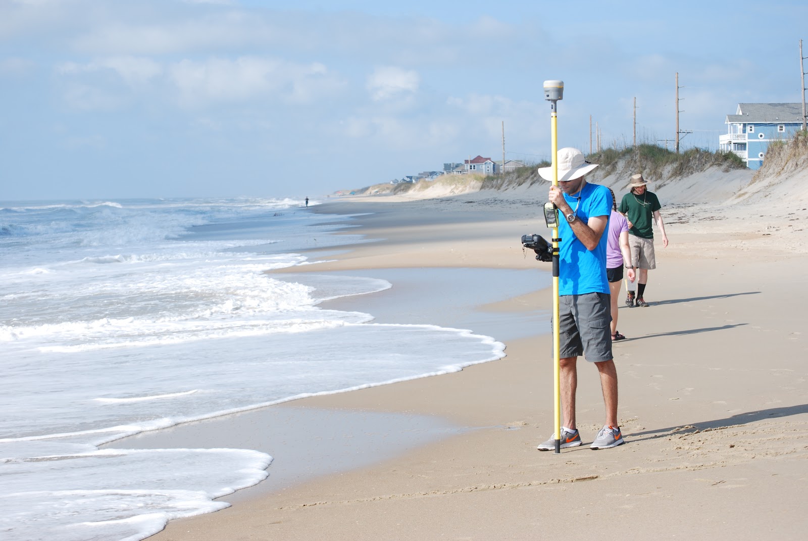
Alireza Gharagozlou (below) is a doctoral student in the Department of Civil, Construction, and Environmental Engineering at NC State University. He studies how to connect predictions of beach and dune erosion to community-wide flooding and serves with Casey Dietrich on NC State’s Coastal & Computational Hydraulics Team. North Carolina Sea Grant has supported their work.

Alireza surveying the beach profile near Hatteras, NC, with RTK-GPS after Hurricane Florence.

2019/04/26 – NC Sea Grant Coastwatch Currents
Model Predicts Storm Impacts on Beaches and Dunes

ncsg

During storms, strong waves and currents can erode beaches and dunes and create low-lying areas vulnerable to flooding. We use field surveys and a computer model called XBeach to predict this erosion, as well as to understand its interactions with storm-driven flooding of larger regions.

Computer models allow us to see how the storm surge and waves impact the beach over time, and which locations are vulnerable to large-scale damage. Good predictions of such storm impacts help emergency managers take better-informed measures to protect coastal areas. Understanding vulnerabilities also instructs highway access design and residential area planning.

We used the XBeach computer model on more than 30 kilometers of Hatteras Island between Avon and Rodanthe to explore how to connect erosion predictions to larger areas. Could XBeach cover more of the island, yet still provide good erosion predictions at beach and dune scales? And how could we connect erosion predictions to other models for storm surge and flooding?

News: Dietrich Promoted to Associate Professor

2019/06/03 – NCSU Civil, Construction, and Environmental Engineering
Faculty Promotions

ncsu-engr

We are pleased to announce that we have had several faculty promoted during this year in recognition of their excellent contributions to research and teaching.

Dr. Casey Dietrich was promoted to Associate Professor with tenure. Dietrich, who leads the Coastal and Computational Hydraulics Team has developed computational models that predict storm surge and coastal flooding. He teaches courses in fluid mechanics and coastal engineering.

News: Modeling Florence’s Storm Surge

2019/04/26 – NCSU College of Engineering
After the Storm

ncsu-engr

Dr. Casey Dietrich, an assistant professor in the Department of Civil, Construction, and Environmental Engineering (CCEE), leads the Coastal and Computational Hydraulics Team and develops computational models that predict storm surge and coastal flooding. Using the model ADCIRC, the team makes predictions about how high sea waters will rise, which areas will be flooded and for how long. These predictions are made for the entire coastline, and then his team visualizes the flooding at the scales of individual buildings and coastal infrastructure. During Florence, Dietrich’s team and collaborators acted as liaisons for state emergency managers to aid their decision making.

“The models are just one data point among many, but they’re helpful in understanding hazards and used to make predictions in real time — partly to make decisions about evacuation, where to deploy resources after, safe places to put emergency vehicles and water supplies,” he said.

The state emergency managers are able to use the flooding predictions to get immediate estimates on damages, which helps communities that are figuring out how much recovery will cost.

After Hurricane Matthew in 2016, Dietrich and his colleagues improved the models’ ability to forecast encroaching water along shorelines. Post-Florence, Dietrich said the research focus is to speed up the model and allow for more permutations to see what might happen if a storm slows down or shifts direction.

News: Post-Florence Field Observations

2018/10/10 – NCSU Civil, Construction, and Environmental Engineering
CCEE Researchers respond rapidly to Hurricane Florence

ncsu-engr

Much of the North Carolina coast is lined with sandy beaches and dunes, which can erode during storms, allowing sand onto major roadways and floodwaters into communities. To develop predictions for this erosion and its effects on infrastructure, it was critical to collect observations shortly after the storm. A multi-disciplinary team led by Dr. Elizabeth Sciaudone traveled to Dare County to collect time-sensitive data at Kitty Hawk, Nags Head, Pea Island, and Hatteras Island. Working in conjunction with the Institute for Transportation Research and Education (ITRE), the Center for Geospatial Analytics in the College of Natural Resources, and industry partner SenseFly, researchers surveyed beach and dune changes. Real-Time Kinematic GPS equipment was used to survey select cross-shore beach and dune profiles and document the extent of dune erosion and overwash (inland sand deposits), such as when NC Highway 12 becomes covered after large storms.

News: Storm Surge Modeling during Hurricane Florence

2018/09/13 – The State of Things on WUNC
Hurricane Florence Coverage from Around the State

Hurricane Florence, which is now a Category 2 storm, continues to bear down on the Carolina coast. The National Weather Service says it is likely to be “the storm of a lifetime” for certain portions of that coastline. Officials have ordered the evacuation of over 1 million people from the coasts of North and South Carolina. … Stasio is joined by Casey Dietrich, a professor in North Carolina State University’s Department of Civil, Construction and Environmental Engineering and leader of its Coastal and Computational Hydraulics Team. Dietrich explains the models currently being refined to help predict and plan for hurricanes and their effects on coastlines.

For this episode of The State of Things, the full-length podcast is embedded below. The interview with Casey Dietrich starts at about the 37-minute mark. It was great to describe our projects with DHS, NSF, and NC Sea Grant as part of this episode about Hurricane Florence.

News: Faster Storm Surge Forecasting

2018/06/12 – DHS Coastal Resilience Center of Excellence
NC State project aims to create faster storm surge forecasting

ncsg

Planning for a hurricane is a complicated process involving many stakeholders and varying degrees of uncertainty. Accurate predictions of storm surge and wave heights are vital to decision-making before, during and after the storm. Creating these predictions through modeling software can be expensive and time-consuming. When dealing with hurricanes, time is critical for emergency managers and other officials.

Helping decision-makers to save valuable prediction time is CRC Principal Investigator Dr. Casey Dietrich of North Carolina State University (NCSU). His project, “Improving the Efficiency of Wave and Surge Models via Adaptive Mesh Resolution,” involves collaboration with co-PI Dr. Clint Dawson at the University of Texas at Austin. Their project focuses on speeding up a widely used prediction tool, ADCIRC. His work with North Carolina Emergency Management during Hurricane Matthew in 2016, and his contributions to developing future disaster resilience specialists, have helped make significant contributions to disaster preparation and recovery.

News: Improving Coastal Flooding Predictions

2018/05/14 – NC Sea Grant Coastwatch Currents
Hurricane Hindsight: Researchers Work to Improve Coastal Flooding Predictions

ncsg

Computer models can make surge predictions based on limited information about storm characteristics such as track, size, maximum wind speed and central pressure. Those parameters are used to predict the surface pressures and wind speeds throughout a coastal region. Those atmospheric conditions are then used to predict how the ocean will respond by generating large waves and surge, and by flooding into low-lying areas.

Given all the variables involved, there’s a lot of room for error in storm wind and surge prediction modeling.

For our study, we wanted to know how forecasting errors affect subsequent coastal flooding predictions. To that end, we needed to answer a couple of questions: First, as a storm moves closer to the coast, how accurate are forecasts of certain storm parameters like track, size, and maximum wind speed? Second, how do those forecasts affect predictions of wind speeds and storm surge?