

Coastal Engineering Expert Casey Dietrich Joins CCEE Faculty

Dietrich’s work addresses coastal processes, ranging from hurricanes to sediment transport, both of which can transform regions, albeit at rates ranging from hours to many years. Dietrich develops models to describe the oceans in deep water and the nearshore and then validates them against the best available measurements and knowledge of natural behavior. These models lead to improved understanding of the natural and built environments. His models have been used for levee design in New Orleans by the U.S. Army Corps of Engineers and for floodplain risk assessment along the Gulf and Atlantic coasts by the Federal Emergency Management Agency. He has also applied his models to forecast coastal flooding during recent storms including Hurricane Isaac (2012) and oil transport following the BP spill in 2010. He plans to extend his models for civil engineering applications along the North Carolina coastline.
Also click here to see the profile of Casey Dietrich in the college’s list of new faculty.
 Storm surge due to hurricanes and tropical storms can result in significant loss of life, property damage, and long-term damage to coastal ecosystems and landscapes. Computer modeling of storm surge is useful for two primary purposes: forecasting of storm impacts for response planning, particularly the evacuation of vulnerable coastal populations; and hindcasting of storms for determining risk, development of mitigation strategies, coastal restoration, and sustainability. Model results must be communicated quickly and effectively, to provide context about the magnitudes and locations of the maximum waves and surges in time for meaningful actions to be taken in the impact region before a storm strikes.
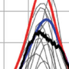
 As phase-averaged spectral wave models continue to grow in sophistication, they are applied more frequently throughout the ocean, from the generation of waves in deep water to their dissipation in the nearshore. Mesh spacings are varied within the computational domain, either through the use of nested, structured meshes or a single, unstructured mesh. This approach is economical, but it can cause accuracy errors in regions where the input parameters are under-resolved. For instance, in regions with a coarse representation of bathymetry, refraction can focus excessive wave energy at a single mesh vertex, causing the computed solution to become non-physical. Limiters based on the Courant–Friedrichs–Lewy (CFL) criteria are proposed for the spectral propagation (refraction and frequency shifting) velocities in SWAN. These limiters are not required for model stability, but they improve accuracy by reducing local errors that would otherwise spread throughout the computational domain. As demonstrated on test cases in deep and shallow water, these limiters prevent the excessive directional turning and frequency shifting of wave energy and control the largest errors in under-resolved regions.
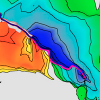
 Hurricane Katrina was historic in magnitude. From ref. 1: “The large size of Katrina throughout its history, combined with the extreme waves generated during its most intense phase, enabled this storm to produce the largest storm surges (reliable observations up to 28 ft) that have ever been observed within the Gulf of Mexico, as determined from analyses of historical records.” The analysis by Grinsted et al. of the effects of rising temperatures on the frequency of Atlantic hurricane surge invokes “events of Katrina magnitude” as a standard by which other events are judged. However, we believe the Katrina benchmark, as used, is seriously flawed, in large part because the tide gauge spatial resolution used was so coarse that none of the locations forming the index ever experienced a true surge event of Katrina magnitude. This casts doubt on the claim that Katrina-level surge events may occur many times per decade by the late 21st century.

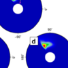
 The Lower Mississippi River protrudes into the Gulf of Mexico, and manmade levees line only the west bank for 55 km of the Lower Plaquemines section. Historically, sustained easterly winds from hurricanes have directed surge across Breton Sound, into the Mississippi River and against its west bank levee, allowing for surge to build and then propagate efficiently upriver and thus increase water levels past New Orleans. This case study applies a new and extensively validated basin- to channel-scale, high-resolution, unstructured-mesh ADvanced CIRCulation model to simulate a suite of historical and hypothetical storms under low to high river discharges. The results show that during hurricanes, (1) total water levels in the lower river south of Pointe à La Hache are only weakly dependent on river flow, and easterly wind-driven storm surge is generated on top of existing ambient strongly flow-dependent river stages, so the surge that propagates upriver reduces with increasing river flow; (2) natural levees and adjacent wetlands on the east and west banks in the Lower Plaquemines capture storm surge in the river, although not as effectively as the manmade levees on the west bank; and (3) the lowering of manmade levees along this Lower Plaquemines river section to their natural state, to allow storm surge to partially pass across the Mississippi River, will decrease storm surge upriver by 1 to 2 m between Pointe à La Hache and New Orleans, independent of river flow.