

Characterizing Hurricane Storm Surge Behavior in Galveston Bay using the SWAN+ADCIRC Model
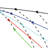
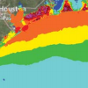
 The SWAN+ADCIRC shallow-water circulation model, validated for Hurricane Ike (2008), was used to develop five synthetic storm surge scenarios for the upper Texas coast in which wind speed was increased and landfall location was shifted 40 km westward. The Hurricane Ike simulation and the synthetic storms were used to study the maximum water elevations in Galveston Bay, as well as the timing and behavior of surge relative to the hurricane track. Sixteen locations indicative of surge behavior in and around Galveston Bay were chosen for analysis in this paper. Results show that water surface elevations present in Galveston Bay are dominated by the counterclockwise hurricane winds and that increasing wind speeds by 15% results in approximately 23% (+/−3%) higher surge. Furthermore, shifting the storm westward causes higher levels of surge in the more populated areas due to more intense, higher shore-normal winds. This research helps to highlight the vulnerability of the upper Texas Gulf Coast to hurricane storm surge and lends insight to storm surge and flood mitigation studies in the Houston–Galveston region.
A Discontinuous Galerkin Coupled Wave Propagation/Circulation Model
 On large geographic scales, ocean waves are represented in a spectral sense via the action balance equation, which propagates action density through both geographic and spectral space. In this paper, a new computational spectral wave model is developed by using discontinuous Galerkin (DG) methods in both geographic and spectral space. DG methods allow for the use of unstructured geographic meshes and higher-order approximations for action propagation in both geographic and spectral space, which we show leads to increased accuracy. This DG spectral wave propagation model is verified and validated through comparisons to manufactured and analytic solutions as well as to the Simulating WAves Nearshore (SWAN) model. Coupled wave/circulation models are needed for many applications including for the interaction between waves and currents during daily wind and tide driven flows. We loosely couple the newDGspectralwavemodel to the DG Shallow Water Equation Model (DG-SWEM), an existing DG circulation model. In addition to formulating the DG method for the coupled wave/circulation model, we derive an a priori error estimate. Preliminary numerical results of the DG coupled wave/circulation model are presented with comparisons to DG-SWEM coupled tightly to SWAN.
Conference: ADCIRC 2014
Strengthening the Hurricane Wave and Surge Forecast Guidance provided to Coastal Communities in North Carolina
 This proposal seeks funds to expand the utility and accuracy of wave, storm surge and flooding forecast guidance that is available to emergency managers in North Carolina using a high-resolution modeling system. Through discussions with them, the guidance from the forecast system will be targeted to their needs, so they can better utilize it while also understanding its strengths and limitations. In addition, the modeled representation of the North Carolina coastal waters will be enhanced to increase accuracy in specific regions of interest.
North Carolina is particularly sensitive to waves, storm surge and flooding, given its geographic location and the protrusion of its coastline into the Atlantic. Severe storms such as hurricanes and nor-easters can devastate the natural and built environment along the complex system of barrier islands, bays and estuaries, and communities that comprise our coast. Several storms have caused flooding in recent years, including but not limited to Bertha and Fran (1996), Floyd (1999), Isabel (2003), Irene (2011) and Sandy (2012). The accurate prediction of waves, storm surge and flooding is essential for evacuation and protection of life and property.
A computational modeling system for North Carolina has been established for forecasting of waves, surge and flooding at high resolution using high-performance computing resources. The models have been validated extensively and applied recently for the analysis of the levee protection system near New Orleans, and the development of new flood risk maps for the Gulf and Atlantic coasts. Within North Carolina, these models are utilized operationally to provide forecast guidance every day for coastal waves and inundation (http://nc-cera.renci.org/).
In this proposed research, the forecast guidance from this modeling system will be expanded beyond Web-based delivery to include additional formats that are targeted to the needs of users within the state. These new formats will represent the guidance at high levels of geographic resolution and will be portable, so users can combine and compare the forecasts with information from other sources. In addition, by identifying regions of interest to them, the models will evolve to improve accuracy in their description of the coastal environment. The resulting guidance will be more powerful because it will be placed directly into the hands of stakeholders who will have participated in its development.
Seminar: Coastal Studies Institute
U.S. IOOS Coastal and Ocean Modeling Testbed: Evaluation of Tide, Wave, and Hurricane Surge Response Sensitivities to Mesh Resolution and Friction in the Gulf of Mexico
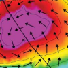
 This paper investigates model response sensitivities to mesh resolution, topographical details, bottom friction formulations, the interaction of wind waves and circulation, and nonlinear advection on tidal and hurricane surge and wave processes at the basin, shelf, wetland, and coastal channel scales within the Gulf of Mexico. Tides in the Gulf of Mexico are modestly energetic processes, whereas hurricane surge and waves are highly energetic. The unstructured-mesh, coupled wind-wave and circulation modeling system, SWAN+ADCIRC, is implemented to generate modeled tidal harmonic constituents and hurricane waves and surge for a Hurricane Ike (2008) hindcast. In the open ocean, mesh resolution requirements are less stringent in achieving accurate tidal signals or matching hurricane surge and wave responses; however, coarser resolution or the absence of intertidal zones decreases accuracy along protected nearshore and inland coastal areas due to improper conveyance and/or lateral attenuation. Bottom friction formulations are shown to have little impact on tidal signal accuracy, but hurricane surge is much more sensitive, especially in shelf waters, where development of a strong shore-parallel current is essential to the development of Ike’s geostrophic setup. The spatial and temporal contributions of wave radiation stress gradients and nonlinear advection were charted for Ike. Nonlinear advection improves model performance by capturing an additional 10–20 cm of geostrophic setup and increasing resonant cross-shelf waves by 30–40 cm. Wave radiation stress gradients improve performance at coastal stations by adding an extra 20–40 cm to water levels.
Hindcast and Validation of Hurricane Ike (2008) Waves, Forerunner, and Storm Surge
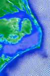
 Hurricane Ike (2008) made landfall near Galveston, Texas, as a moderate intensity storm. Its large wind field in conjunction with the Louisiana-Texas coastline’s broad shelf and large scale concave geometry generated waves and surge that impacted over 1000 km of coastline. Ike’s complex and varied wave and surge response physics included: the capture of surge by the protruding Mississippi River Delta; the strong influence of wave radiation stress gradients on the Delta adjacent to the shelf break; the development of strong wind driven shore-parallel currents and the associated geostrophic setup; the forced early rise of water in coastal bays and lakes facilitating inland surge penetration; the propagation of a free wave along the southern Texas shelf; shore-normal peak wind-driven surge; and resonant and reflected long waves across a wide continental shelf. Preexisting and rapidly deployed instrumentation provided the most comprehensive hurricane response data of any previous hurricane. More than 94 wave parameter time histories, 523 water level time histories, and 206 high water marks were collected throughout the Gulf in deep water, along the nearshore, and up to 65 km inland. Ike’s highly varied physics were simulated using SWAN+ADCIRC, a tightly coupled wave and circulation model, on SL18TX33, a new unstructured mesh of the Gulf of Mexico, Caribbean Sea, and western Atlantic Ocean with high resolution of the Gulf’s coastal floodplain from Alabama to the Texas-Mexico border. A comprehensive validation was made of the model’s ability to capture the varied physics in the system.