

 Coastal Louisiana and Mississippi are especially prone to large hurricanes due to their geographic location in the north-central Gulf of Mexico. Several recent hurricanes have devastated the region, creating complicated environments of waves and storm surge. Katrina (2005) and Gustav (2008) made landfall in southeastern Louisiana, and their counter-clockwise winds pushed surge onto the Louisiana-Mississippi continental shelf, into the low-lying wetlands surrounding the Mississippi River, and over and through the levee system that protects metropolitan New Orleans. Rita (2005) and Ike (2008) passed farther to the west, moved across the Texas-Louisiana continental shelf, and created surge that flooded large portions of southwestern Louisiana.
These hurricanes demand detailed hindcasts that depict the evolution of waves and surge during these storm events. These hindcasts can be used to map the likely floodplains for insurance purposes, to understand how the current protection system responded during each storm, and to design a new protection system that will resist better the waves and surge. In addition, the resulting computational model can be used to forecast the system’s response to future storm events.
The work described herein represents a significant step forward in the modeling of hurricane waves and surge in complicated nearshore environments. The system is resolved with unprecedented levels of detail, including mesh sizes of 1km on the continental shelf, less than 200m in the wave breaking zones and inland, and down to 20-30m in the fine-scale rivers and channels. The resulting hindcasts are incredibly accurate, with close matches between the modeled results and the measured high-water marks and hydrograph data. They can be trusted to provide a faithful representation of the evolution of waves and surge during all four hurricanes.
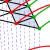
This work also describes advancements in the coupling of wave and surge models. This coupling has been implemented typically with heterogeneous meshes, which is disadvantageous because it requires intra-model interpolation at the boundaries of the nested, structured wave meshes and inter-model interpolation between the wave and circulation meshes. The recent introduction of unstructured wave models makes nesting unnecessary. The unstructured-mesh SWAN wave and ADCIRC circulation models are coupled in this work so that they run on the same unstructured mesh. This identical, homogeneous mesh allows the physics of wave-circulation interactions to be resolved correctly in both models. The unstructured mesh can be applied on a large domain to follow seamlessly all energy from deep to shallow water. There is no nesting or overlapping of structured wave meshes, and there is no inter-model interpolation. Variables and forces reside at identical, vertex-based locations. Information can be passed without interpolation, thus reducing significantly the communication costs.
The coupled SWAN+ADCIRC model is highly scalable and integrates seamlessly the physics and numerics from deep ocean to shelf to floodplain. Waves, water levels and currents are allowed to interact in complex problems and in a way that is accurate and efficient to thousands of computational cores. The coupled model is validated against extensive measurements of waves and surge during the four recent Gulf hurricanes. Furthermore, the coupling paradigm employed by SWAN+ADCIRC does not interfere with the already-excellent scalability of the component models, and the coupled model maintains its scalability to 7,168 computational cores. SWAN+ADCIRC is well-suited for the simulation of hurricane waves and surge.
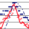 Few wave measurements have been made in wetlands during high-energy, surge events, such as hurricanes. During Hurricane Gustav in 2008, many nearshore wave measurements were made in Southeastern Louisiana. These data are used to verify a nearshore wave modeling system and to explore the characteristics of hurricane waves in wetlands. The modeling system consists of the wave generation model WAM, the nearhsore wave model STWAVE, and the circulation model ADCIRC. The measurements confirm reasonable success in modeling the waves. The measurements and modeling also expose some of the problems of measuring waves in highly-variable water depths under hurricane forcing and modeling waves in rapidly degrading wetlands.
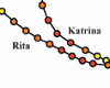 Hurricanes Katrina and Rita were powerful storms that impacted southern Louisiana and Mississippi during the 2005 hurricane season. In Part I, the authors describe and validate a high-resolution coupled riverine flow, tide, wind, wave, and storm surge model for this region. Herein, the model is used to examine the evolution of these hurricanes in more detail. Synoptic histories show how storm tracks, winds, and waves interacted with the topography, the protruding Mississippi River delta, east-west shorelines, man-made structures, and low-lying marshes to develop and propagate storm surge. Perturbations of the model, in which the waves were not included, show the proportional importance of the wave radiation stress gradient induced setup.
 A coupled system of wind, wind wave, and coastal circulation models has been implemented for southern Louisiana and Mississippi to simulate riverine flows, tides, wind waves, and hurricane storm surge in the region. The system combines the NOAA Hurricane Research Division Wind Analysis System (H*WIND) and the Interactive Objective Kinematic Analysis (IOKA) kinematic wind analyses, the Wave Model (WAM) offshore and Steady-State Irregular Wave (STWAVE) nearshore wind wave models, and the Advanced Circulation (ADCIRC) basin to channel-scale unstructured grid circulation model. The system emphasizes a high-resolution (down to 50m) representation of the geometry, bathymetry, and topography; nonlinear coupling of all processes including wind wave radiation stress-induced set up; and objective specification of frictional parameters based on land-cover databases and commonly used parameters. Riverine flows and tides are validated for no storm conditions, while winds, wind waves, hydrographs, and high water marks are validated for Hurricanes Katrina and Rita.
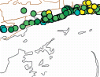
 Hurricane Katrina caused devastating flooding in St. Bernard Parish, Louisiana. Storm surge surrounded the polder that comprises heavily populated sections of the Parish in addition to the Lower 9th Ward section of Orleans Parish. Surge propagated along several pathways to reach levees and walls around the polder’s periphery. Extreme water levels led to breaches in the levee/wall system which, along with wave overtopping and steady overflow, led to considerable flood water entering the polder. Generation and evolution of the storm surge as it propagated into the region is examined using results from the SL15 regional application of the ADCIRC storm surge model. Fluxes of water into the region through navigation channels are compared to fluxes which entered through Lake Borgne and over inundated wetlands surrounding the lake. Fluxes through Lake Borgne and adjacent wetlands were found to be the predominant source of water reaching the region. Various sources of flood water along the polder periphery are examined. Flood water primarily entered through the east and west sides of the polder. Different peak surges and hydrograph shapes were experienced along the polder boundaries, and reasons for the spatial variability in surge conditions are discussed.
 This paper provides a brief overview of several ongoing modeling projects that seek to predict the impact of physical features on hurricane storm surge and waves along the Louisiana Gulf Coast. All of the modeling projects described herein make use of a coupled ADCIRC/STWAVE computer model that is being developed specifically for capturing the inundation dynamics of Southern Louisiana. The projects also make use of a common statistical framework and a suite of 152 synthetic hurricane wind and pressure fields that have been developed to represent the storm dynamics along this region of the coast. This paper provides an overview of the statistical method, the computer models being applied, the physical features resolved by the finite element mesh, the validation exercises, the process for coupling and running the ADCIRC/STWAVE model, and a description of several investigations for which the coupled modeling system is being applied. Preliminary results and conclusions are presented.
 Mass balance error has been computed traditionally by using conventional fluxes derived from the conservation of mass equation, but recent literature supports a method based on fluxes that are consistent with the discretization of the governing equations. By comparing the mass residuals from these two methods to the truncation errors produced by the discretization of the governing equations, we show that the conventional fluxes produce mass residuals that are more descriptive of the overall behavior of the model, i.e., they are better correlated with truncation error. Then we demonstrate that these mass residuals can be used as a criterion for mesh refinement. In an example using a one-dimensional shallow water model, we demonstrate that, by moving nodes from regions with large mass residuals to regions with small mass residuals, a mesh can be developed that shows less truncation error than a mesh developed by using localized truncation error analysis. And, in an example using a two-dimensional shallow water model, we demonstrate that the computed solution can be improved in regions with large mass residuals through mesh refinement.
 Coastal ocean hydrodynamic models are used to simulate water surface elevations and circulation in oceans, lakes, estuaries, rivers and floodplains. One such model is ADCIRC (ADvanced CIRCulation), which was originally developed more than 15 years ago and which is used for a variety of purposes, including naval fleet operations, storm surge predictions, and larvae transport. ADCIRC assumed fixed land boundaries until a wetting and drying algorithm was implemented in 1995. However, this algorithm had two components that limited the performance of the model. First, nodes were required to remain “wet” or “dry” for a user-specified number of time steps before changing states. This component became restrictive in relatively flat regions, such as a flood plain, where it caused oscillations and slowed the propagation of flood waves. Second, in regions with steep bathymetry, mass balance problems and instabilities would occur when a thin film of water was allowed to flow uninterrupted. Changes based on a more physically-accurate description of the wetting and drying process were made recently to address these two problems. This paper describes the wetting and drying algorithm and those changes, and it applies the improved algorithm to an idealized domain that was designed specifically to test the two problem areas. The improved algorithm provides better stability and mass balance properties.