

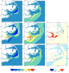
 Storm surge prediction models rely on an accurate representation of the wind conditions. In this paper, we examine the sensitivity of surge predictions to forecast uncertainties in the track and strength of a storm (storm strength is quantified by the power dissipation of the associated wind field). This analysis is performed using Hurricane Arthur (2014), a Category 2 hurricane, which made landfall along the North Carolina (NC) coast in early July 2014. Hindcast simulations of a coupled hydrodynamic-wave model are performed on a large unstructured mesh to analyze the surge impact of Arthur along the NC coastline. The effects of Arthur are best represented by a post-storm data assimilated wind product with parametric vortex winds providing a close approximation. Surge predictions driven by forecast advisories issued by the National Hurricane Center (NHC) during Arthur are analyzed. The storm track predictions from the NHC improve over time. However, successive advisories predict an unrealistic increase in the storm’s strength. Due to these forecast errors, the global root mean square errors of the predicted wind speeds and water levels increase as the storm approaches landfall. The relative impacts of the track and strength errors on the surge predictions are assessed by replacing forecast storm parameters with the best known post-storm information about Arthur. In a “constant track” analysis, Arthur’s post storm determined track is used in place of the track predictions of the different advisories but each advisory retains its size and intensity predictions. In a “constant storm strength” analysis, forecast wind and pressure parameters are replaced by corresponding parameters extracted from the post storm analysis while each advisory retains its forecast storm track. We observe a strong correlation between the forecast errors and the wind speed predictions. However, the correlation between these errors and the forecast water levels is weak signifying a non-linear response of the shallow coastal waters to meteorological forcing.
Category Archives: Journal Papers
Sensitivity of Storm Surge Predictions to Atmospheric Forcing during Hurricane Isaac
 Storm surge and overland flooding can be predicted with computational models at high levels of resolution. To improve efficiency in forecasting applications, surge models often use atmospheric forcing from parametric vortex models, which represent the surface pressures and wind fields with a few storm parameters. The future of storm surge prediction could involve real-time coupling of surge and full-physics atmospheric models; thus, their accuracies must be understood in a real hurricane scenario. The authors compare predictions from a parametric vortex model (using forecast tracks from the National Hurricane Center) and a full-physics coupled atmosphere-wave-ocean model during Hurricane Isaac (2012). The predictions are then applied within a tightly coupled, wave and surge modeling system describing the northern Gulf of Mexico and the floodplains of southwest Louisiana. It is shown that, in a hindcast scenario, a parametric vortex model can outperform a data-assimilated wind product, and given reasonable forecast advisories, a parametric vortex model gives reasonable surge forecasts. However, forecasts using a full-physics coupled model outperformed the forecast advisories and improved surge forecasts. Both approaches are valuable for forecasting the coastal impacts associated with tropical cyclones
An Earth’s Future Special Collection: Impacts of the coastal dynamics of sea level rise on low-gradient coastal landscapes
 Rising sea level represents a significant threat to coastal communities and ecosystems, including altered habitats and increased vulnerability to coastal storms and recurrent inundation. This threat is exemplified in the northern Gulf of Mexico, where low topography, marshes, and a prevalence of tropical storms have resulted in extensive coastal impacts. The ability to facilitate adaptation and mitigation measures relies, in part, on the development of robust predictive capabilities that incorporate complex biological processes with physical dynamics. Initiated in 2010, the 6-year Ecological Effects of Sea Level Rise—Northern Gulf of Mexico project applied a transdisciplinary science approach to develop a suite of integrated modeling platforms informed by empirical data that are capable of evaluating a range of climate change scenarios. This special issue highlights resultant integrated models focused on tidal hydrodynamics, shoreline morphology, oyster ecology, coastal wetland vulnerability, and storm surges that demonstrate the need for dynamic models to incorporate feedbacks among physical and biological processes in assessments of sea level rise effects on coastal systems. Effects are projected to be significant, spatially variable and nonlinear relative to sea level rise rates. Scenarios of higher sea level rise rates are projected to exceed thresholds of wetland sustainability, and many regions will experience enhanced storm surges. Influenced by an extensive collaborative stakeholder engagement process, these assessments on the coastal dynamics of sea level rise provide a strong foundation for resilience measures in the northern Gulf of Mexico and a transferable approach for application to other coastal regions throughout the world.
Characterizing Hurricane Storm Surge Behavior in Galveston Bay using the SWAN+ADCIRC Model
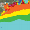
 The SWAN+ADCIRC shallow-water circulation model, validated for Hurricane Ike (2008), was used to develop five synthetic storm surge scenarios for the upper Texas coast in which wind speed was increased and landfall location was shifted 40 km westward. The Hurricane Ike simulation and the synthetic storms were used to study the maximum water elevations in Galveston Bay, as well as the timing and behavior of surge relative to the hurricane track. Sixteen locations indicative of surge behavior in and around Galveston Bay were chosen for analysis in this paper. Results show that water surface elevations present in Galveston Bay are dominated by the counterclockwise hurricane winds and that increasing wind speeds by 15% results in approximately 23% (+/−3%) higher surge. Furthermore, shifting the storm westward causes higher levels of surge in the more populated areas due to more intense, higher shore-normal winds. This research helps to highlight the vulnerability of the upper Texas Gulf Coast to hurricane storm surge and lends insight to storm surge and flood mitigation studies in the Houston–Galveston region.
A Discontinuous Galerkin Coupled Wave Propagation/Circulation Model
 On large geographic scales, ocean waves are represented in a spectral sense via the action balance equation, which propagates action density through both geographic and spectral space. In this paper, a new computational spectral wave model is developed by using discontinuous Galerkin (DG) methods in both geographic and spectral space. DG methods allow for the use of unstructured geographic meshes and higher-order approximations for action propagation in both geographic and spectral space, which we show leads to increased accuracy. This DG spectral wave propagation model is verified and validated through comparisons to manufactured and analytic solutions as well as to the Simulating WAves Nearshore (SWAN) model. Coupled wave/circulation models are needed for many applications including for the interaction between waves and currents during daily wind and tide driven flows. We loosely couple the newDGspectralwavemodel to the DG Shallow Water Equation Model (DG-SWEM), an existing DG circulation model. In addition to formulating the DG method for the coupled wave/circulation model, we derive an a priori error estimate. Preliminary numerical results of the DG coupled wave/circulation model are presented with comparisons to DG-SWEM coupled tightly to SWAN.
U.S. IOOS Coastal and Ocean Modeling Testbed: Evaluation of Tide, Wave, and Hurricane Surge Response Sensitivities to Mesh Resolution and Friction in the Gulf of Mexico
 This paper investigates model response sensitivities to mesh resolution, topographical details, bottom friction formulations, the interaction of wind waves and circulation, and nonlinear advection on tidal and hurricane surge and wave processes at the basin, shelf, wetland, and coastal channel scales within the Gulf of Mexico. Tides in the Gulf of Mexico are modestly energetic processes, whereas hurricane surge and waves are highly energetic. The unstructured-mesh, coupled wind-wave and circulation modeling system, SWAN+ADCIRC, is implemented to generate modeled tidal harmonic constituents and hurricane waves and surge for a Hurricane Ike (2008) hindcast. In the open ocean, mesh resolution requirements are less stringent in achieving accurate tidal signals or matching hurricane surge and wave responses; however, coarser resolution or the absence of intertidal zones decreases accuracy along protected nearshore and inland coastal areas due to improper conveyance and/or lateral attenuation. Bottom friction formulations are shown to have little impact on tidal signal accuracy, but hurricane surge is much more sensitive, especially in shelf waters, where development of a strong shore-parallel current is essential to the development of Ike’s geostrophic setup. The spatial and temporal contributions of wave radiation stress gradients and nonlinear advection were charted for Ike. Nonlinear advection improves model performance by capturing an additional 10–20 cm of geostrophic setup and increasing resonant cross-shelf waves by 30–40 cm. Wave radiation stress gradients improve performance at coastal stations by adding an extra 20–40 cm to water levels.
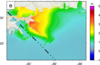
Hindcast and Validation of Hurricane Ike (2008) Waves, Forerunner, and Storm Surge
 Hurricane Ike (2008) made landfall near Galveston, Texas, as a moderate intensity storm. Its large wind field in conjunction with the Louisiana-Texas coastline’s broad shelf and large scale concave geometry generated waves and surge that impacted over 1000 km of coastline. Ike’s complex and varied wave and surge response physics included: the capture of surge by the protruding Mississippi River Delta; the strong influence of wave radiation stress gradients on the Delta adjacent to the shelf break; the development of strong wind driven shore-parallel currents and the associated geostrophic setup; the forced early rise of water in coastal bays and lakes facilitating inland surge penetration; the propagation of a free wave along the southern Texas shelf; shore-normal peak wind-driven surge; and resonant and reflected long waves across a wide continental shelf. Preexisting and rapidly deployed instrumentation provided the most comprehensive hurricane response data of any previous hurricane. More than 94 wave parameter time histories, 523 water level time histories, and 206 high water marks were collected throughout the Gulf in deep water, along the nearshore, and up to 65 km inland. Ike’s highly varied physics were simulated using SWAN+ADCIRC, a tightly coupled wave and circulation model, on SL18TX33, a new unstructured mesh of the Gulf of Mexico, Caribbean Sea, and western Atlantic Ocean with high resolution of the Gulf’s coastal floodplain from Alabama to the Texas-Mexico border. A comprehensive validation was made of the model’s ability to capture the varied physics in the system.
Limiters for Spectral Propagation Velocities in SWAN
 As phase-averaged spectral wave models continue to grow in sophistication, they are applied more frequently throughout the ocean, from the generation of waves in deep water to their dissipation in the nearshore. Mesh spacings are varied within the computational domain, either through the use of nested, structured meshes or a single, unstructured mesh. This approach is economical, but it can cause accuracy errors in regions where the input parameters are under-resolved. For instance, in regions with a coarse representation of bathymetry, refraction can focus excessive wave energy at a single mesh vertex, causing the computed solution to become non-physical. Limiters based on the Courant–Friedrichs–Lewy (CFL) criteria are proposed for the spectral propagation (refraction and frequency shifting) velocities in SWAN. These limiters are not required for model stability, but they improve accuracy by reducing local errors that would otherwise spread throughout the computational domain. As demonstrated on test cases in deep and shallow water, these limiters prevent the excessive directional turning and frequency shifting of wave energy and control the largest errors in under-resolved regions.