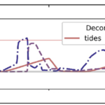
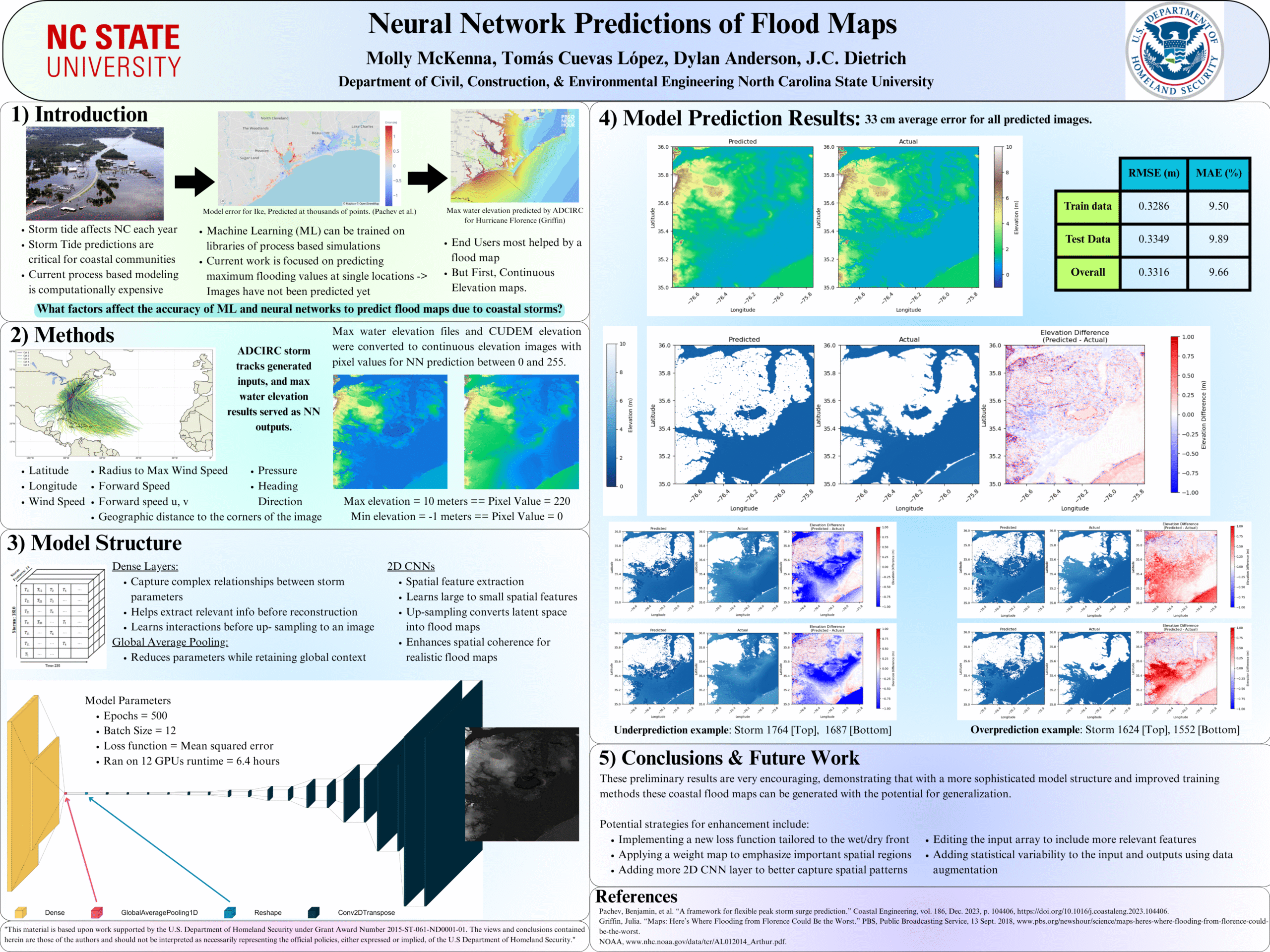
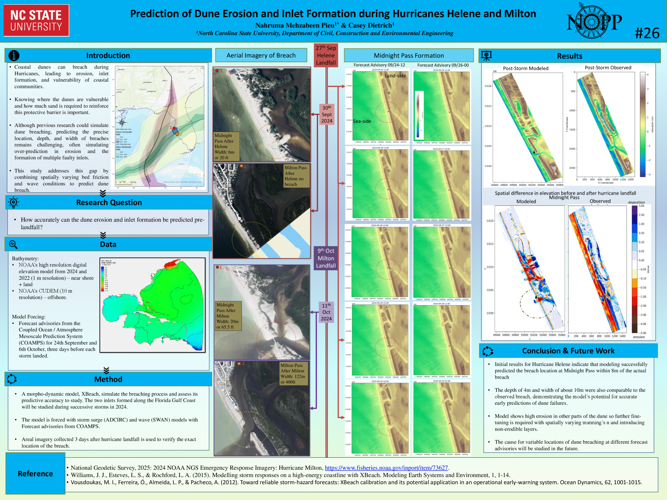
With sea-level rise, flooding in coastal communities is now common during the highest high tides. Floods also occur at normal tidal levels when rainfall overcomes stormwater infrastructure that is partially submerged by tides. Data describing this type of compound flooding is scarce and, therefore, it is unclear how often these floods occur and the extent to which non-tidal factors contribute to flooding. We combine measurements of flooding on roads and within storm drains with a numerical model to examine processes that contribute to flooding in Carolina Beach, NC, USA — a community that chronically floods outside of extreme storms despite flood mitigation infrastructure to combat tidal flooding. Of the 43 non-storm floods we measured during a year-long study period, one-third were unexpected based on the tidal threshold used by the community for flood monitoring. We introduce a novel model coupling between an ocean-scale hydrodynamic model (ADCIRC) and a community-scale surface water and pipe flow model (3Di) to quantify contributions from multiple flood drivers. Accounting for the compounding effects of tides, wind, and rain increases flood water levels by up to 0.4 m compared to simulations that include only tides. Setup from sustained (non-storm) regional winds causes deeper, longer, more extensive flooding during the highest high tides and can cause floods on days when flooding would not have occurred due to tides alone. Rainfall also contributes to unexpected floods; because tides submerge stormwater outfalls on a daily basis, even minor rainstorms lead to flooding as runoff has nowhere to drain. As a particularly low-lying coastal community, Carolina Beach provides a glimpse into future challenges that coastal communities worldwide will face in predicting, preparing for, and adapting to increasingly frequent flooding from compounding tidal and non-tidal drivers atop sea-level rise.
TH Thelen, KA Anarde, JC Dietrich, M Hino (2024). “Wind and Rain Compound with Tides to Cause Frequent and Unexpected Coastal Floods.” Water Research, 266, 122339, DOI: 10.1016/j.watres.2024.122339.


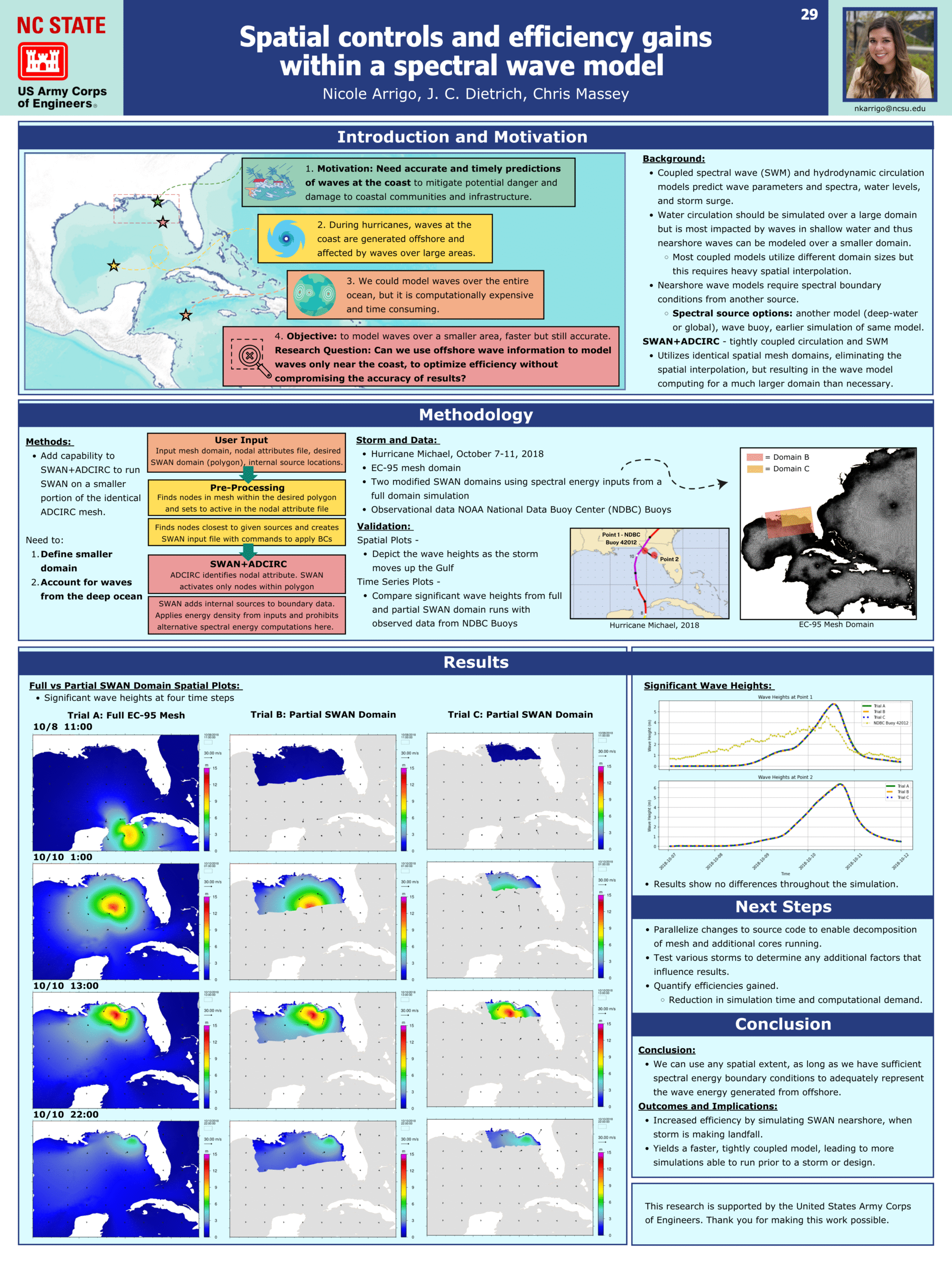
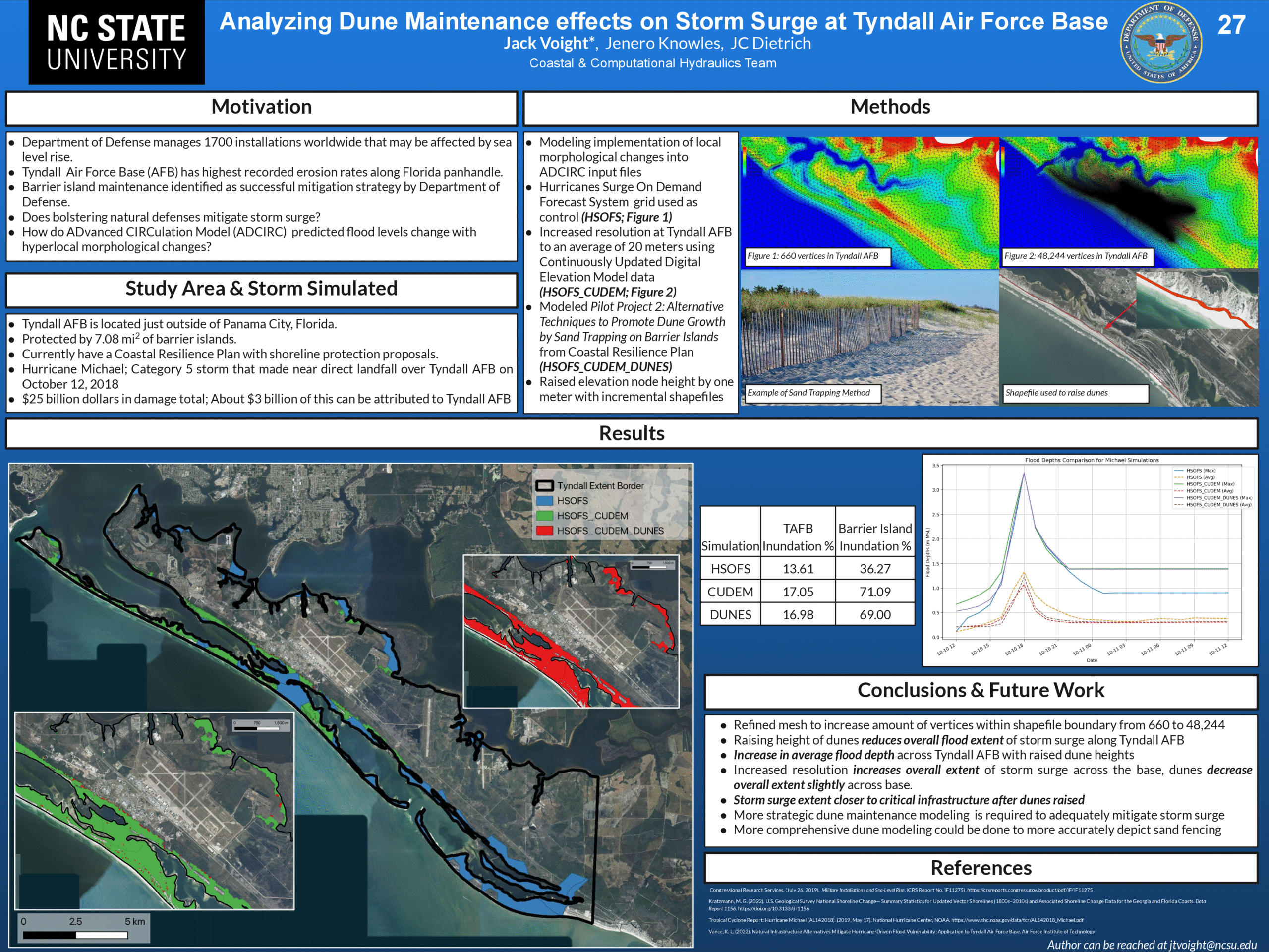
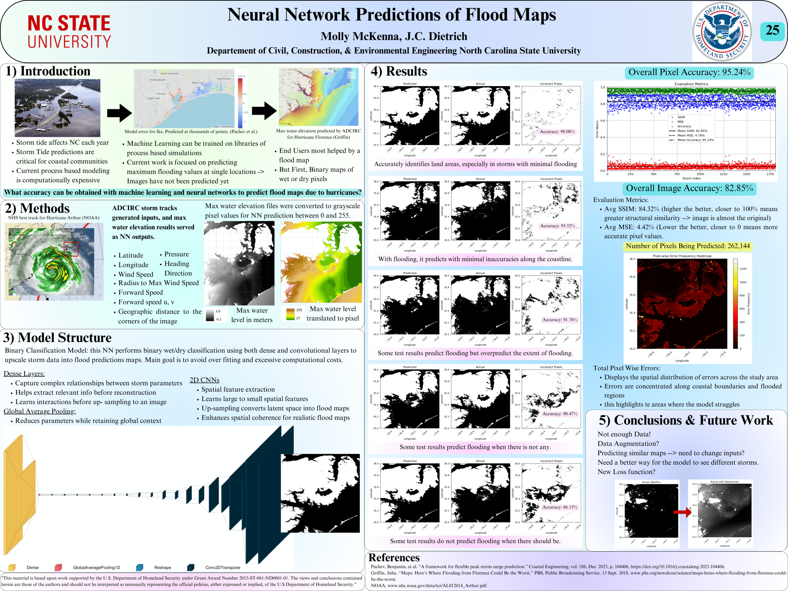
 Flooding due to storm surge can propagate through coastal regions to threaten the built and natural environments. This propagation is controlled by geographic features of varying scales, from the largest oceans to the smallest marsh channels and sandy dunes. Numerical models to predict coastal flooding have been improved via the use of subgrid corrections, which use information about the smallest-scale flow controls to provide corrections to coarser scale grids. Although previous studies have demonstrated the benefits of subgrid models, especially how coarser models can be more efficient without a trade-off in accuracy, this study systematically investigates subgrid corrections in storm surge models across large domains. Here, we apply the widely used ADVanced CIRCulation (ADCIRC) storm surge model with revised subgrid corrections to develop guidance for resolution of coastal regions. Recent hurricanes in the South Atlantic Bight are simulated with five models, each with varying resolution of coastal islands, estuaries, rivers, and floodplains. Model performance is quantified via comparisons with observed data and high-resolution simulations. Clear degradation is observed in the subgrid model performance as minimum mesh resolution becomes coarser than the width of channels conveying flow or the barrier islands blocking flow. Therefore, subgrid model mesh resolution should account for spatial scales of local flow pathways and barrier islands to maintain proper model mass and momentum transfer. However, with subgrid modeling this can be done at much coarser (and thus computationally faster) resolutions than with conventional models.
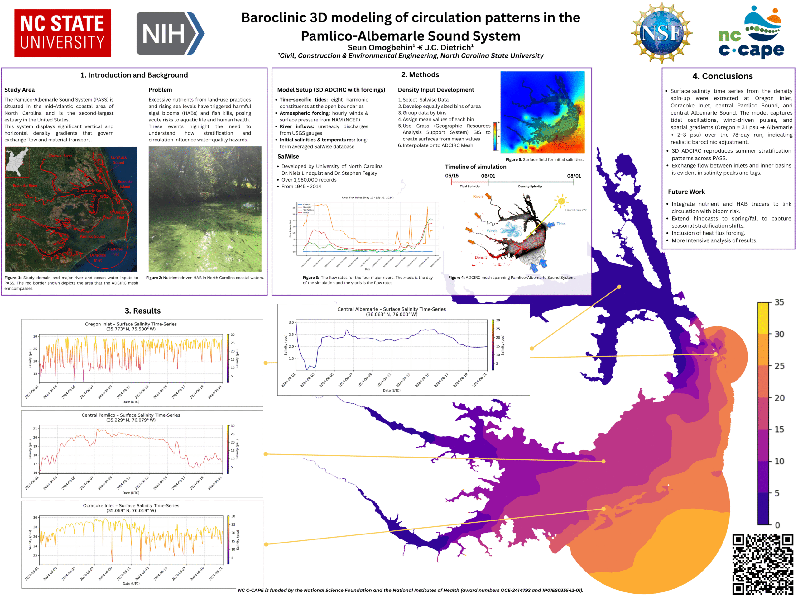
 As sea levels continue to rise, coastal communities are searching for strategies to reduce flooding of low-lying roads, property, and stormwater drainage networks. Here we focus on the development of adaptation strategies for communities that experience flooding outside of extreme storms like hurricanes due to sea level rise (SLR). Processes that contribute to these floods can include tides, rainfall, wind setup, groundwater, and infrastructure failure (Gold et al., 2023). Here we present a framework to test the effectiveness of adaptation strategies in reducing multi-driver chronic flooding at both current and future sea levels. This framework integrates coastal engineering and stakeholder input to 1) identify adaptation strategies that are preferred by a community that frequently floods and 2) test the effectiveness of these strategies with a numerical model under both current and future conditions.

