

Tag Archives: Rosemary Cyriac
Conference: SIAM CSE 2015
R Cyriac, JC Dietrich+, RA Luettich Jr, JG Fleming, BO Blanton. “Strengthening the Hurricane Wave and Surge Forecast Guidance provided to Coastal Communities in North Carolina.” SIAM Conference on Computational Science and Engineering, Salt Lake City, Utah, 16-17 March 2015.
+ Presenter, if other than first author.
News: Developing Storm Surge Visualization
2015/03/10 – CCEE
Developing Storm Surge Visualization
Developing Storm Surge Visualization

When tropical storms approach, local, state and federal emergency managers seek predictions of storm surge and coastal flooding. In a project supported by NC Sea Grant, Dr. Casey Dietrich and Ph.D. student Rosemary Cyriac are improving the dissemination of flooding predictions to end-users by producing predictions in popular file formats. The Coastal Emergency Risk Assessment (CERA, http://nc-cera.renci.org/) provides a Web-based interface for visualizing surge predictions from computer models. Dr. Dietrich’s team is working with emergency managers in North Carolina’s coastal counties and with other decision makers. Results from daily model simulations are sent to these individuals, and they are widely used to predict inundation and flooding levels. Such predictions are also needed for engineering design and evacuation decisions. Model outputs are converted into formats compatible with commonly used visualization software, such as ArcGIS and Google Earth. By providing predictions to local emergency managers in a useful format, the information can be more easily integrated with other data, thereby making the information more accessible to those who most need it.
Poster: NCSU Symposiums 2015
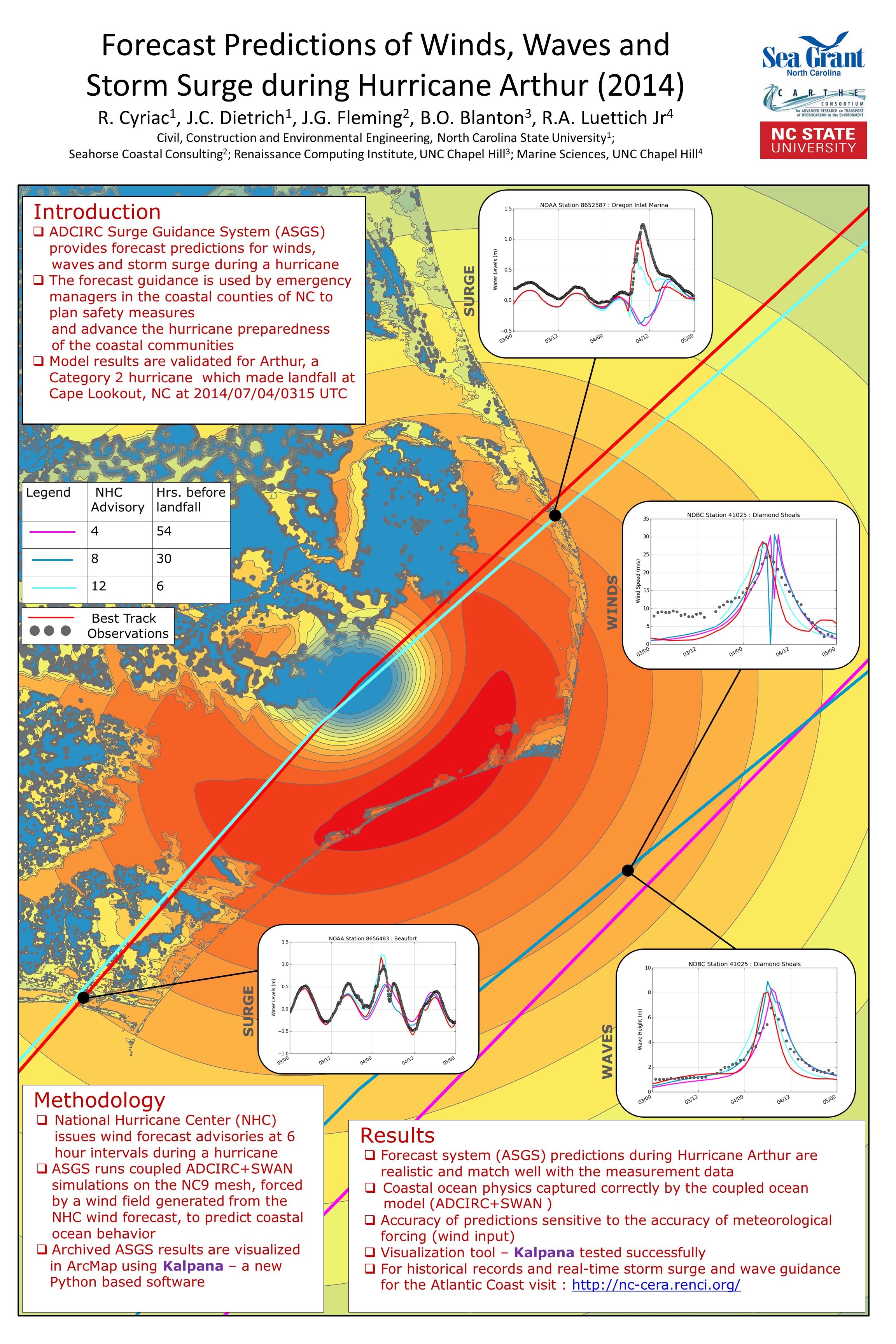
R Cyriac, JC Dietrich, JG Fleming, BO Blanton, RA Luettich, C Kaiser. “Forecast Predictions of Winds, Waves and Storm Surge during Hurricane Arthur (2014).” Graduate Student Research Symposium, North Carolina State University, 25 March 2015.
R Cyriac, JC Dietrich, JG Fleming, BO Blanton, RA Luettich, C Kaiser. “Forecast Predictions of Winds, Waves and Storm Surge during Hurricane Arthur (2014).” Environmental, Water Resources and Coastal Engineering Research Symposium, North Carolina State University, 06 March 2015.
Seminar: Old Dominion University
News: GoMRI Renews CARTHE
2014/11/15 – GoMRI
Gulf of Mexico Research Initiative Awards $140 Million to Support Research
Gulf of Mexico Research Initiative Awards $140 Million to Support Research

The Gulf of Mexico Research Initiative (GoMRI) has selected 12 research consortia to conduct scientific studies of the impacts of oil, dispersed oil, and dispersant on the Gulf of Mexico ecosystem and public health. These research investments focus on improving our fundamental understanding of the implications of events such as the Macondo well blowout, and on developing improved spill mitigation, oil and gas detection, characterization and remediation technologies. The consortia were chosen following a competitive, merit review process that evaluated research applications submitted to GoMRI in response to its RFP-IV program solicitation.
Through the RFP-IV program, GoMRI is awarding $140 million to support research to be carried out from 2015 through 2017.
2014/11/18 – UM RSMAS
UM Rosenstiel School Scientists Receive Over $29 Million to Study Effects of Crude Oil Spills

Under the leadership of UM Rosenstiel School Professor Tamay Özgökmen, the CARTHE research consortium received over $20 million to continue the research necessary to predict the fate of oil released into the environment to help inform and guide response teams in the event of future oil spills. This second phase of CARTHE, which supports research through 2017, will help scientists develop and improve computational tools to accurately predict the fate of hydrocarbons found in crude oil that are released into the environment, and help to guide risk management and response efforts in mitigation and restoration of the economy and the ecosystem in situations like the Deepwater Horizon oil spill.
“An integral part of any informed response to a future event like the 2010 Deepwater Horizon oil spill requires knowledge of the distribution of pollutants in the water column and the ability to predict where and how fast the pollutants will spread,” said Özgökmen, lead investigator of CARTHE. “This information is also crucial to estimate the pollutants, impact on the local ecosystem and coastal communities.”
News: Developing Storm Surge Visualization
2014/10/29 – NC Sea Grant Coastwatch Currents
Picture This: Developing Storm Surge Visualization
Picture This: Developing Storm Surge Visualization
When a tropical storm or hurricane develops in the open ocean, the National Hurricane Center, known as NHC, issues advisories that anticipate the track and intensity of the wind field. These advisories predict when and where the hurricane is expected to make landfall, even when the storm is far away from the coast.
This information serves as an input for the ocean model, which then predicts the water levels or storm surges, and wave heights created by these winds at various locations along our coastline for the coming days. These results will convey a greater meaning to the end user when visualized properly. The chief objective for our project is to improve the communication of these model outputs to the end-user by producing them in popular file formats like that of GIS based shapefiles and KMZ files used in Google Earth.